Climate data guide content with tag atmosdiagnostics
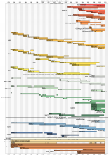
 Atmospheric Reanalysis: Overview & Comparison Tables
Years of record
- N/A
Reanalysis a systematic approach to produce data sets for climate monitoring and research. Reanalyses are created via an unchanging ("frozen") data assimilation scheme and model(s) which ingest all available observations every 6-12 hours over the period being analyzed. This unchanging framework provides a dynamically consistent estimate of the climate state at each time…
Main variables and Earth System components
Atmosphere-
Formats
- N/A
-
Timestep
- N/A
-
Domain
- N/A
Experts contributing reviews
- Dee, Dick, Fasullo, John, Shea, Dennis, Walsh, John
 CERES EBAF: Clouds and Earth's Radiant Energy Systems (CERES) Energy Balanced and Filled (EBAF)
Years of record
- to
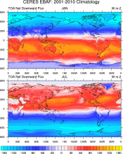
The CERES-EBAF product provides 1-degree regional, zonal and global monthly mean Top-of-Atmosphere (TOA) and surface (SFC) longwave (LW), shortwave (SW), and net (NET) fluxes under clear and all-sky conditions. EBAF is used for climate model evaluation, estimating the Earth's global mean energy budget, and to infer meridional heat transport. The data synthesized to…
Experts contributing reviews
- Loeb, Norman
 Cloud observations from MODIS
Years of record
- to
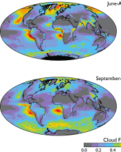
The Moderate Resolution Imaging Spectroradiometer (MODIS) is scanning instrument that makes measurements in 36 spectral bands from the visible to the thermal infrared at spatial resolutions from 250 m to 1 km. There are MODIS instruments aboard two sun-synchronous polar-orbiting NASA satellites: Terra, which has a daytime equatorial crossing at about 10:30 am local time…
-
Timestep
- Daily, Monthly, Weekly
-
Domain
- Global
-
Collections
- Diagnostic Data Sets, NCAR-DOE-CESM, atmosdiagnostics, Obs4MIPS
Experts contributing reviews
- Pincus, Robert
 CMAP: CPC Merged Analysis of Precipitation
Years of record
- to
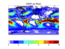
CMAP refers to a collection of precipitation data sets, though the 2.5°x2.5° global monthly version is probably the most widely used. This data set is constructed from an analysis of gauge data and satellite-derived precipitation estimates. An "enhanced" version (CMAP/A) is also available, which provides global coverage by filling in gaps with precipitation forecasts…
-
Timestep
- Monthly, Pentad
-
Domain
- Global
Experts contributing reviews
- Arkin, Phil, Xie, PIngping
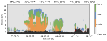 Combined CloudSat spaceborne radar and CALIPSO spaceborne lidar cloud fraction dataset (3S-GEOPROF-COMB)
Years of record
- to
A global (82S-82N) cloud fraction data set, providing a unique view of cloud vertical structure, has been developed based on the complimentary spaceborne remote sensing capabilities of the CloudSat radar and the CALISPSO lidar. The data set provides monthly mean cloud fraction over several vertical layers for 2006-2019.
-
Formats
- netCDF
-
Timestep
- Monthly, Seasonal, Annual
-
Domain
- Global
-
Collections
- Diagnostic Data Sets, NCAR-DOE-CESM, atmosdiagnostics
Experts contributing reviews
- Bertrand, Leah, Kay, Jennifer
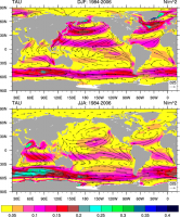 COREv2 Air-Sea Surface Fluxes
Years of record
- to
The Coordinated Ocean Research Experiments version 2 (COREv2) data set consists of a globally complete set of air-sea fluxes of momentum, heat and freshwater for 1948-2009 at monthly resolution. This data set serves as a set of common atmospheric boundary conditions that has been used by the ocean modeling community to force and compare a diverse set of…
Main variables and Earth System components
Atmosphere Evaporation Precipitation Radiation Wind Stress Land Runoff and Streamflow Ocean Surface Flux-
Formats
- netCDF
-
Timestep
- Monthly
-
Domain
- Global
-
Collections
- Diagnostic Data Sets, NCAR-DOE-CESM, atmosdiagnostics, oceandiagnostics
Experts contributing reviews
- Yeager, Stephen
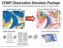 COSP: Cloud Feedback Model Intercomparison Project (CFMIP) Observation Simulator Package
Years of record
- N/A
Cloud processes and feedbacks are recognized as the largest uncertainty in climate model projections. Progress in understanding the roles of clouds in the response of the Earth to changes in external forcing (GHG, aerosoles, etc.) has in part been hampered by the lack of a consistent definition of clouds and cloud types in models and observations. It has been difficult…
-
Formats
- N/A
-
Timestep
- N/A
-
Domain
- Global
-
Collections
- Diagnostic Data Sets, NCAR-DOE-CESM, atmosdiagnostics
Experts contributing reviews
- Kay, Jennifer
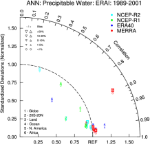
 ERA-Interim
Years of record
- to
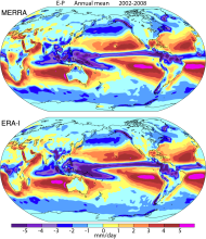
Using a much improved atmospheric model and assimilation system from those used in ERA-40, ERA-Interim represents a third generation reanalysis. Several of the inaccuracies exhibited by ERA-40 such as too-strong precipitation over oceans from the early 1990's onwards and a too-strong Brewer-Dobson circulation in the stratosphere, were eliminated or significantly reduced…
Main variables and Earth System components
Atmosphere Air Temperature Geopotential Height Precipitable water Precipitation-
Timestep
- Sub-daily, Daily, Monthly
-
Domain
- Global
Experts contributing reviews
- Dee, Dick
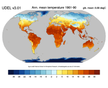 Global (land) precipitation and temperature: Willmott & Matsuura, University of Delaware
Years of record
- to
A series of gridded temperature and precipitation data sets. Station records that served as bases for the Terrestrial Air Temperature: 1900-2014 Gridded Monthly Time Series (Version 4.01) and Terrestrial Precipitation: 1900-2014 Gridded Monthly Time Series (Version 4.01) archives are used here to help create new gridded climatologies of monthly and annual average air…
Main variables and Earth System components
Atmosphere Air Temperature Air Temperature at 2m Precipitation-
Timestep
- Climatology, Monthly
-
Domain
- Global
-
Collections
- Diagnostic Data Sets, NCAR-DOE-CESM, atmosdiagnostics
Experts contributing reviews
- Matsuura, Kenji
 GPCC: Global Precipitation Climatology Centre
Years of record
- to
The GPCC provides gridded gauge-analysis products derived from quality controlled station data. Two products are for climate: (a) the Full Data Reanalysis Product (1901-2010) is recommended for global and regional water balance studies, calibration/validation of remote sensing based rainfall estimations and verification of numerical models, and (b) the VASClimO 50…
-
Timestep
- Climatology, Daily, Monthly
-
Domain
- Global
Experts contributing reviews
- N/A
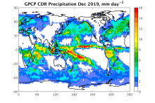 GPCP (Monthly): Global Precipitation Climatology Project
Years of record
- to
Data from rain gauge stations, satellites, and sounding observations have been merged to estimate monthly rainfall on a 2.5-degree global grid from 1979 to the present. The careful combination of satellite-based rainfall estimates provides the most complete analysis of rainfall available to date over the global oceans, and adds necessary spatial detail to the rainfall…
-
Timestep
- Climatology, Monthly
-
Domain
- Global
Experts contributing reviews
- Pendergrass, Angeline, Wang, Jian-Jian
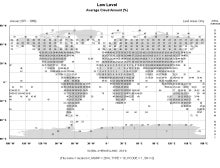 Gridded Climatology of Clouds from Surface Observations Worldwide (1971-2008)
Years of record
- to
This digital archive provides multi-year monthly, seasonal, and annual averages in 5x5-degree grid boxes (or 10x10-degree boxes for some quantities over the ocean). Daytime and nighttime averages, as well as the diurnal average (average of day and night), are given. Nighttime averages were computed using only those reports that met an "illuminance criterion" (i.e., made…
-
Formats
- ascii
-
Timestep
- Climatology, Monthly, Seasonal
-
Domain
- Global
-
Collections
- Diagnostic Data Sets, NCAR-DOE-CESM, atmosdiagnostics
Experts contributing reviews
- Norris, Joel
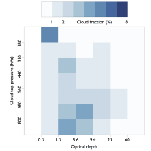 ISCCP: International Satellite Cloud Climatology Project
Years of record
- to
The International Satellite Cloud Climatology Project (ISCCP) makes use of routine observations by operational weather satellites to provide a long-term (1983-2009), gridded, global record of cloud properties. ISCCP uses observations in the visible and infrared window portions of the spectrum to determine cloud optical thickness and cloud top temperature, from which the…
-
Timestep
- Climatology, Sub-daily, Monthly
-
Domain
- Global
Experts contributing reviews
- Pincus, Robert
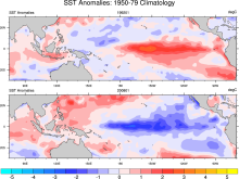 Merged Hadley-NOAA/OI Sea Surface Temperature & Sea-Ice Concentration (Hurrell et al, 2008)
Years of record
- to
The merged Hadley-OI sea surface temperature (SST) and sea ice concentration (SIC) data sets were specifically developed as surface forcing data sets for AMIP style uncoupled simulations of the Community Atmosphere Model (CAM). The Hadley Centre's SST/SIC version 1.1 (HADISST1), which is derived gridded, bias-adjusted in situ observations, were merged with the NOAA-…
Main variables and Earth System components
Cryosphere Sea Ice Concentration Ocean SST - sea surface temperature-
Formats
- netCDF
-
Timestep
- Monthly
Experts contributing reviews
- N/A
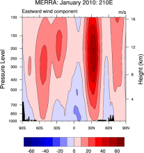 NASA MERRA
Years of record
- to
The Modern Era Retrospective-Analysis for Research and Applications (MERRA) was undertaken by NASA’s Global Modeling and Assimilation Office with two primary objectives: to place observations from NASA’s Earth Observing System satellites into a climate context and to improve upon the hydrologic cycle represented in earlier generations of reanalyses. MERRA was generated…
Main variables and Earth System components
Atmosphere Air Temperature Geopotential Height Precipitable water Water Vapor-
Timestep
- Sub-daily, Monthly
-
Domain
- Global
Experts contributing reviews
- N/A
 NCEP-NCAR (R1): An Overview
Years of record
- to
NCEP-NCAR (R1) is the original reanalysis effort. It uses a frozen global state-of-the-art global data assimilation system (as of 11 January 1995). The original database was enhanced (additional, quality checked datasets) by NCAR's Data Support Section. Originally planned to span 1957-96 ("40-Year Reanalysis Project"), it was extended back to 1948 and continues to this…
-
Timestep
- Sub-daily, Daily, Monthly
-
Domain
- Global
Experts contributing reviews
- N/A
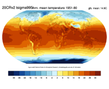 NOAA 20th-Century Reanalysis, Version 2 and 2c
Years of record
- to
The Twentieth Century Reanalysis (20CR) provides a comprehensive global atmospheric circulation data set spanning 1850-2014. Its chief motivation is to provide an observational validation data set, with quantified uncertainties, for assessing climate model simulations of the 20th century, with emphasis on the statistics of daily weather. The analyses are generated by…
-
Timestep
- Sub-daily, Daily, Monthly
-
Domain
- Global
Experts contributing reviews
- N/A