Climate Forecast System Reanalysis (CFSR)

The CFSR is a third generation reanalysis product. It is a global, high resolution, coupled atmosphere-ocean-land surface-sea ice system designed to provide the best estimate of the state of these coupled domains over this period. The CFSR includes (1) coupling of atmosphere and ocean during the generation of the 6 hour guess field, (2) an interactive sea-ice model, and (3) assimilation of satellite radiances. The CFSR global atmosphere resolution is ~38 km (T382) with 64 levels. The global ocean is 0.25° at the equator, extending to a global 0.5° beyond the tropics, with 40 levels. The global land surface model has 4 soil levels and the global sea ice model has 3 levels. The CFSR atmospheric model contains observed variations in carbon dioxide (CO2), together with changes in aerosols and other trace gases and solar variations. With these variable parameters, the analyzed state will include estimates of changes in the Earth system climate due to these factors. The current CFSR will be extended as an operational, real time product into the future. -from RDA abstract on CFSR
Key Strengths
Superior to previous NCEP reanalyses with respect to: improved model, finer resolution, advanced assimilation schemes, atmosphere-land-ocean-sea ice coupling, assimilates satellite radiances rather than retrievals
Accounts for changing CO2 and other trace gasses, aerosols, and solar variations
Approaches the horizontal resolution of regional reanalyses like the NARR and Arctic System Reanalysis
Key Limitations
Relatively few evaluations of CFSR have been conducted so the performance is not well-known
Ocean-atmosphere interactions are not used directly. Rather the information is used for background information. The actual reanalysis is uncoupled.
Research
Cite this page
Acknowledgement of any material taken from or knowledge gained from this page is appreciated:
National Center for Atmospheric Research Staff (Eds). Last modified "The Climate Data Guide: Climate Forecast System Reanalysis (CFSR).” Retrieved from https://climatedataguide.ucar.edu/climate-data/climate-forecast-system-reanalysis-cfsr on 2026-02-08.
Citation of datasets is separate and should be done according to the data providers' instructions. If known to us, data citation instructions are given in the Data Access section, above.
Acknowledgement of the Climate Data Guide project is also appreciated:
Schneider, D. P., C. Deser, J. Fasullo, and K. E. Trenberth, 2013: Climate Data Guide Spurs Discovery and Understanding. Eos Trans. AGU, 94, 121–122, https://doi.org/10.1002/2013eo130001
Key Figures
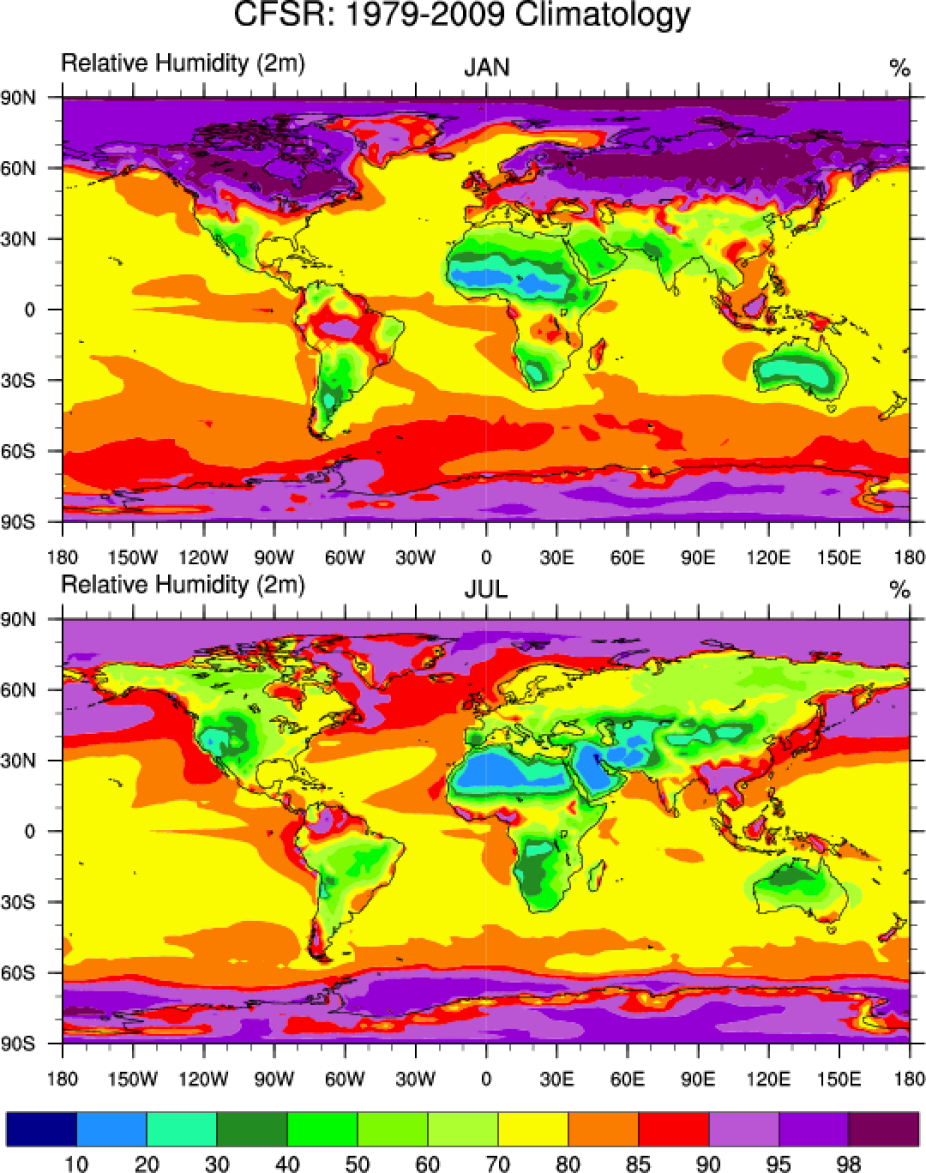
Climatological (1979-2009) relative humidity at 2-meters. [Climate Data Guide; D. Shea]
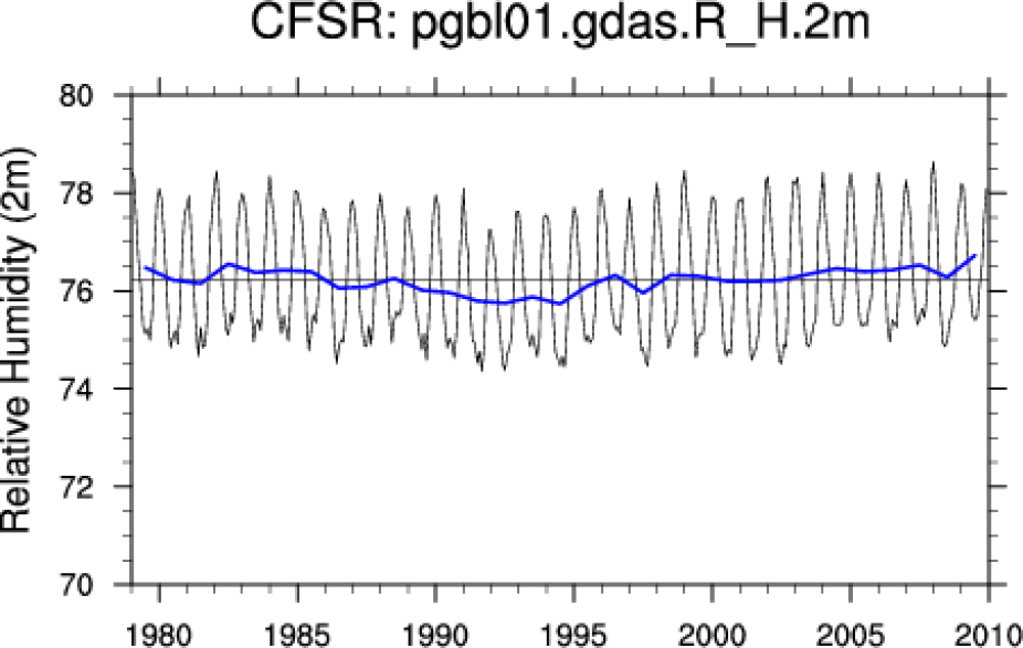
Annual cycle of relative humidity at 2-meters. The blue line is the annual average. The horizontal black line is the long term average. [Climate Data Guide; D. Shea]
Other Information
- Saha, Suranjana, and Coauthors, 2014: The NCEP Climate Forecast System Version 2. J. Climate, 27, 2185-2208
- Saha, Suranjana, and Coauthors, 2010: The NCEP Climate Forecast System Reanalysis. Bull. Amer. Meteor. Soc., 91, 1015–1057.
- Kevin E. Trenberth, John T. Fasullo, Jessica Mackaro. (2011) Atmospheric Moisture Transports from Ocean to Land and Global Energy Flows in Reanalyses. Journal of Climate 24:18, 4907-4924
- Wang, W. et al (2010): An assessment of the surface climate in the NCEP climate forecast system reanalysis. Clim Dyn.
- Dee D.P. et al,\(2014): Toward a Consistent Reanalysis of the Climate System. Bull. Amer. Meteor. Soc., 95, 1235–1248.