Climate Data Records: Overview
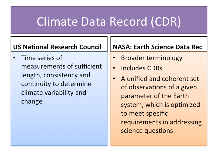
As defined by a US National Research Council committee, a Climate Data Record (CDR) is "a time series of measurements of sufficient length, consistency and continuity to determine climate variability and change." In the US, agencies such as NASA and NOAA have sponsored operational and grant programs to create and curate CDRs. The focus has been on the reprocessing of satellite-derived records. The NOAA program includes a "research to operations" initiative to transfer the development of routine and widely used data records from an individual PI's research group to an operational NOAA center. NASA also uses the broader term "Earth Science Data Records (ESDR)," which includes CDRs and is described by NASA as "a unified and coherent set of observations of a given parameter of the Earth system, which is optimized to meet specific requirements in addressing science questions."
The European Space Agency (ESA) has also launched an initiative to provide satellite based CDRs (Hollmann et al, 2013).
To find Climate Data Records or learn more, see the Climate Data Records collection on the Climate Data Guide, browse the links under Data Access, or visit the NOAA or NASA pages linked at right under Product Websites.
Key Strengths
Key Limitations
Expert User Guidance
#The Climate Data Guide will not make its own determination of which data sets qualify as CDRs or ESDRs, but instead will assign the Climate Data Record tag to data sets discussed on this website that have been developed under one of the major NOAA or NASA programs. Essentially, this tag links to a list of all such designated data sets. The tag can also be used as a search term on the advanced search page.
Even with CDRs, there will still be multiple data sets of the same variable, and the CDR data set of a given variable may not always be the best one for some research questions and purposes.
-David Schneider, NCAR, Jan, 2012##
Cite this page
Acknowledgement of any material taken from or knowledge gained from this page is appreciated:
National Center for Atmospheric Research Staff (Eds). Last modified "The Climate Data Guide: Climate Data Records: Overview.” Retrieved from https://climatedataguide.ucar.edu/climate-data/climate-data-records-overview on 2026-07-21.
Citation of datasets is separate and should be done according to the data providers' instructions. If known to us, data citation instructions are given in the Data Access section, above.
Acknowledgement of the Climate Data Guide project is also appreciated:
Schneider, D. P., C. Deser, J. Fasullo, and K. E. Trenberth, 2013: Climate Data Guide Spurs Discovery and Understanding. Eos Trans. AGU, 94, 121–122, https://doi.org/10.1002/2013eo130001
Key Figures
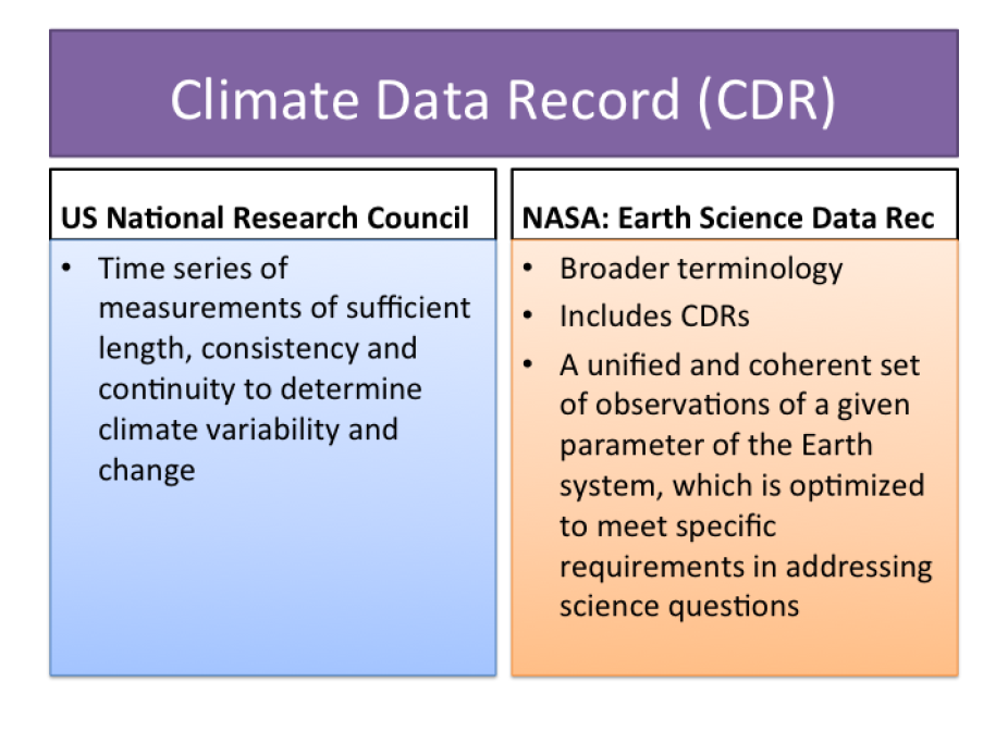
Definition: Climate Data Record (CDR) and Earth Science Data Records (ESDR).
Other Information
- Bates, J. J. and J. L. Privette (2012), A maturity model for assessing the completeness of climate data records, Eos Trans. AGU, 93(44), 441, doi:10.1029/2012EO440006.
- Hollmann, R. et al (2013): The ESA Climate Change Iniative: Satellite Data Records for Essential Climate Variables. BAMS, Oct. 2013: 64: 1541-1552.