Land
Important land variables include soil moisture, vegetation coverage, surface radiation budgets and more. Overview pages summarize and compare selected datasets of a given variable.
To find a specific dataset or variable, jump to the search box below or click your desired variable from among the blue sub-category buttons.
To see only the datasets accompanied by expert commentaries, select the "Datasets with guidance" button when using the search box.
Dataset Overviews
Sub-categories
Climate datasets
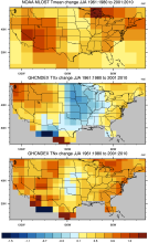 GHCNDEX: Gridded Temperature and Precipitation Climate Extremes Indices (CLIMDEX data)
Years of Record
- 1951-01 to 2014-02
GHCNDEX provides gridded, station-based indices of temperature- and precipitation- related climate extremes. It is intended for detection and attribution studies, climate…
Main variables and Earth System components
Atmosphere Maximum Air Temperature Minimum Air Temperature Land Freeze/ThawExperts contributing reviews
- N/A
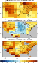 HadEX2: Gridded Temperature and Precipitation Climate Extremes Indices (CLIMDEX data)
Years of Record
- 1901-01 to 2010-12
Note: HadEX2 has been superseded by HadEX3. HadEX2 provides gridded, station-based indices of temperature- and precipitation- related climate extremes. It is intended for…
Main variables and Earth System components
Atmosphere Maximum Air Temperature Minimum Air Temperature Land Freeze/ThawExperts contributing reviews
- N/A
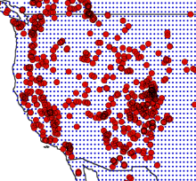 Drought atlases from tree rings
Years of Record
- 0000-01 to 2005-12
Tree-ring drought atlases provide a paleoclimate analog to modern drought indices, most commonly the Palmer Drought Severity Index (PDSI). Produced on a regular lat-…
-
Timestep
- Annual
-
Domain
- North America
-
Collections
- N/A
Experts contributing reviews
- Cook, Edward
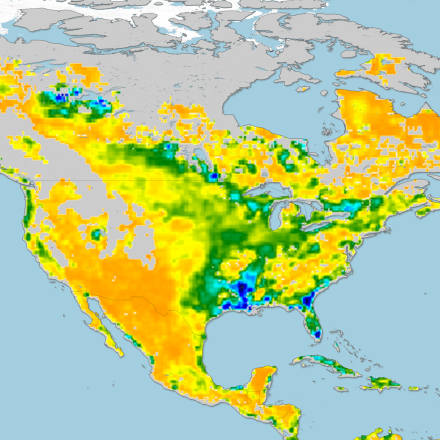
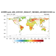 NDVI: Normalized-difference-vegetation-index: NOAA AVHRR
Years of Record
- 1981-06 to 2018-03
Normalized Difference Vegetation Index (NDVI) values are derived from surface reflectance data acquired by the Advanced Very High Resolution Radiometer (AVHRR) sensor. By…
Experts contributing reviews
- N/A
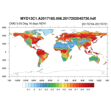 NDVI and EVI: Vegetation Indices (MODIS)
Years of Record
- 2002-02 to 2018-03
MODIS vegetation indices, produced on 16-day and monthly intervals and at multiple spatial resolutions, provide consistent spatial and temporal comparisons of vegetation…
Main variables and Earth System components
Land Enhanced Vegetation Index (EVI) NDVI" Normalized Difference Vegetation IndexExperts contributing reviews
- N/A
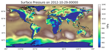
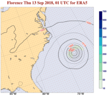 ERA5 atmospheric reanalysis
Years of Record
- 1940-01 to 2023-07
ERA5, the successor to ERA-Interim, provides global, hourly estimates of atmospheric, ocean-wave and land-surface variables, at a horizontal resolution of 31 km and 137…
-
Timestep
- Sub-daily, Daily, Monthly
-
Domain
- Global
-
Collections
- Diagnostic Data Sets
Experts contributing reviews
- Hersbach, Hans
 Soil Moisture Data Sets: Overview & Comparison Tables
Years of Record
Soil moisture is a state variable of the land that crosses the interfaces of several disciplines, including meteorology, hydrology, climatology and ecology. Soil moisture…
-
Formats
- N/A
-
Timestep
- N/A
-
Domain
- N/A
-
Collections
- Overview / Comparison page
Experts contributing reviews
- Dirmeyer, Paul
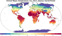 TerraClimate: Global, high-resolution gridded temperature, precipitation, and other water balance variables
Years of Record
- 1958-01 to 2018-12
TerraClimate is a global gridded dataset of meteorological and water balance variables for 1958-present, available on a monthly timestep. Its relatively fine spatial…
Main variables and Earth System components
Atmosphere Air Temperature Maximum Air Temperature Minimum Air Temperature Potential Evapotranspiration Precipitation Wind Snow Water Equivalent Land evapotranspiration Runoff and Streamflow Soil MoistureExperts contributing reviews
- Abatzoglou, John
 An overview of paleoclimate information from high-resolution lake sediment records: Strengths, limitations and key databases
Years of Record
Accumulated sediments at the bottom of lakes are invaluable archives of past climate and environmental change. These sediments contain a variety of physical, geochemical,…
Main variables and Earth System components
Atmosphere Air Temperature Precipitation Biosphere Pollen Land-
Formats
- ascii | csv | Linked Paleo Data (LiPD)
-
Timestep
- Annual, Decadal, Irregular
-
Domain
- Global
-
Collections
- N/A
Experts contributing reviews
- Larocca, Laura | Broadman, Ellie
 Making sense of data from Land Surface Models (LSMs)
Years of Record
The land surface is a dynamic and complex component of the Earth system, shaping climate and biogeochemical cycles and serving as the origin of many anthropogenic impacts…
-
Formats
- N/A
-
Timestep
- N/A
-
Domain
- N/A
-
Collections
- N/A
Experts contributing reviews
- Mankin, Justin | Lesk, Corey
 HadEX3: Gridded Temperature and Precipitation Climate Extremes Indices (CLIMDEX data)
Years of Record
- 1901-01 to 2018-12
HadEX3 provides gridded, station-based indices of temperature- and precipitation- related climate extremes and supersedes HadEX2. It is intended for global and continental…
Main variables and Earth System components
Atmosphere Air Temperature at 2m Maximum Air Temperature Minimum Air Temperature Land Freeze/ThawExperts contributing reviews
- Dunn, Robert
 Global Land Evaporation Amsterdam Model (GLEAM)
Years of Record
- 1980-01 to 2022-12
The Global Land Evaporation Amsterdam Model (GLEAM) is a satellite remote sensing-based set of algorithms dedicated to the estimation of evaporation and soil moisture at…
Main variables and Earth System components
Biosphere land evaporation Land evapotranspiration Soil Moisture-
Formats
- N/A
-
Timestep
- Daily
-
Domain
- Global
-
Collections
- N/A
Experts contributing reviews
- Miralles, Diego | Koppa, Akash
 SMAP-Derived 1-km Downscaled Surface Soil Moisture
Years of Record
- 2015-04 to 2022-09
This data product contains global daily 1 km resolution surface soil moisture (SM) derived from the Soil Moisture Active Passive (SMAP) L-band radiometer observations.…
-
Formats
- N/A
-
Timestep
- Daily
-
Domain
- Global
-
Collections
- N/A
Experts contributing reviews
- Lakshmi, Venkataraman | Fang, Bin
 Global dataset of solar-induced chlorophyll fluorescence (GOSIF)
Years of Record
- 2000-02 to 2022-12
GOSIF is a global, gridded dataset of solar-induced chlorophyll fluorescence (SIF). SIF, an energy flux re-emitted by plants a few nanoseconds after light absorption,…
Main variables and Earth System components
Biosphere GPP: Gross Primary Production solar-induced chlorophyll fluorescence (SIF) Land Gross Primary Production-
Formats
- N/A
-
Timestep
- Monthly, Weekly
-
Domain
- Global
-
Collections
- N/A
Experts contributing reviews
- Xiao, Jingfeng | Li, Xing
 Lake Water Storage: GloLakes
Years of Record
- 1984-01 to 2025-01
Lakes and reservoirs are critical components of the hydrological cycle, particularly due to their central role in many human systems. Long-term measurements of lakes is…
-
Formats
- N/A
-
Timestep
- Monthly
-
Domain
- Global
-
Collections
- BAMS State of the Climate
Experts contributing reviews
- N/A
 CAM6+DART Reanalysis and Surface Forcings
Years of Record
- 01-2011 to 12-2020
The CAM6+DART (Community Atmospheric Model version 6 + Data Assimilation Research Testbed) Reanalysis is an 80-member global atmospheric reanalysis with 6 hourly output…
-
Formats
- N/A
-
Timestep
- Sub-daily, Weekly
-
Domain
- Global
-
Collections
- Boundary Conditions
Experts contributing reviews
- Raeder, Kevin
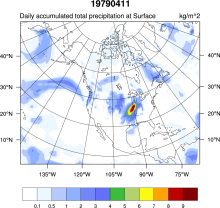 NCEP NARR
Years of Record
- 1979-01 to 2022-02
A high resolution (32km x 29 pressure levels) data set focused upon the North American Region. Relative to the NCEP-DOE (R2) it has a much improved land-hydrology, diurnal…
Main variables and Earth System components
Atmosphere Air Temperature Geopotential Height Precipitable water Land-
Formats
- GRIB
-
Timestep
- Climatology, Sub-daily, Monthly
-
Domain
- North America
-
Collections
- N/A
Experts contributing reviews
- N/A
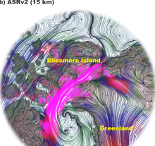 Arctic System Reanalysis (ASR)
Years of Record
- 2000-01 to 2012-12
The Arctic System Reanalysis is a multi-agency, university-led retrospective analysis (reanalysis) of the Greater Arctic. ASR is produced using high-resolution versions of…
Experts contributing reviews
- N/A
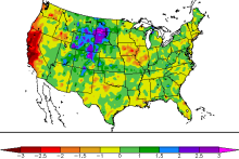
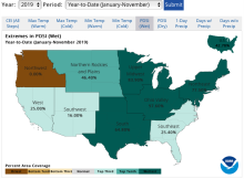
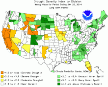 Palmer Drought Severity Index (PDSI)
Years of Record
The Palmer Drought Severity Index (PDSI) uses readily available temperature and precipitation data to estimate relative dryness. It is a standardized index that generally…
-
Timestep
- Monthly
-
Domain
- Global
-
Collections
- Climate Analysis Section (CAS) Data Catalog
Experts contributing reviews
- Dai, Aiguo | Bui, Sang | Lenssen, Nathan
 Standardized Precipitation Index (SPI)
Years of Record
- 1949-01 to 2018-07
The Standardized Precipitation Index (SPI) is a widely used index to characterize meteorological drought on a range of timescales. On short timescales, the SPI is closely…
-
Formats
- N/A
-
Timestep
- Monthly
-
Domain
- N/A
-
Collections
- N/A
Experts contributing reviews
- Keyantash, John
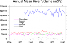 Freshwater Discharge: 1948-2004
Years of Record
- 1948-01 to 2004-12
"A dataset of historical monthly streamflow at the farthest downstream stations for the world’s 925 largest ocean-reaching rivers has been created for community use.…
-
Timestep
- Monthly
-
Domain
- Global
-
Collections
- Climate Analysis Section (CAS) Data Catalog
Experts contributing reviews
- N/A
 U.S. Climate Extremes Index (CEI)
Years of Record
- 1910-01 to 2019-11
The U.S. Climate Extremes Index (CEI) was first presented in 1995 as a framework for quantifying observed changes in climate within the contiguous United States. At…
Main variables and Earth System components
Atmosphere Air Temperature Maximum Air Temperature Minimum Air Temperature Precipitation Wind Land Drought-
Formats
- ascii
-
Timestep
- Monthly, Seasonal, Annual
-
Domain
- North America
-
Collections
- N/A
Experts contributing reviews
- Gleason, Karin
 COREv2 Air-Sea Surface Fluxes
Years of Record
- 1949-01 to 2006-12
The Coordinated Ocean Research Experiments version 2 (COREv2) data set consists of a globally complete set of air-sea fluxes of momentum, heat and freshwater for 1948…
Main variables and Earth System components
Atmosphere Evaporation Precipitation Radiation Wind Stress Land Runoff and Streamflow Ocean Surface Flux-
Formats
- netCDF
-
Timestep
- Monthly
-
Domain
- Global
-
Collections
- Diagnostic Data Sets, NCAR-DOE-CESM, atmosdiagnostics, oceandiagnostics
Experts contributing reviews
- Yeager, Stephen
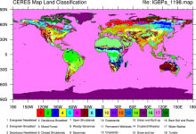 CERES: IGBP Land Classification
Years of Record
The International Geosphere–Biosphere Programme (IGBP) defines ecosystems surface classifications. The CERES (Clouds and Earth's Radiant Energy System)10-minute data can be…
Experts contributing reviews
- N/A
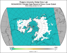 Snow Cover Extent (Northern Hemisphere) Climate Data Record, by Rutgers
Years of Record
- 1966-10 to 2021-09
The Snow Cover Extent Climate Data Record extends from the late 1960s to present. Historical analyses based on visual inspection have been digitized and combined with modern…
-
Timestep
- Monthly, Weekly
-
Domain
- North America
-
Collections
- Climate Data Record, Diagnostic Data Sets, NCAR-DOE-CESM, landdiagnostics
Experts contributing reviews
- Estilow, Thomas W. | Robinson, David
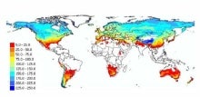
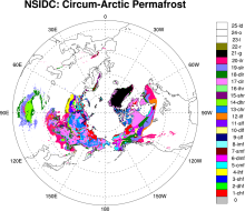 Permafrost: Circum-Arctic Map of Permafrost and Ground Ice Conditions
Years of Record
The circumpolar permafrost and ground ice data contribute to a unified international data set that depicts the distribution and properties of permafrost and ground ice in…
-
Timestep
- Climatology
-
Domain
- NH - Northern Hemisphere
-
Collections
- N/A
Experts contributing reviews
- N/A
 Randolph Glacier Inventory data base of global glacier outlines
Years of Record
The Randolph Glacier Inventory (RGI) is a global data base of glacier outlines. It is intended for estimates of ice volume and glacier mass at regional and global scales.…
Experts contributing reviews
- N/A
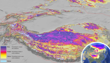 Global Permafrost Zonation Index Map
Years of Record
This data set contains a global (excluding Antarctica) 1 km map of permafrost zonation. It is an estimate of to what degree permafrost exists in a region nearly everywhere,…
Experts contributing reviews
- Gruber, Stephan
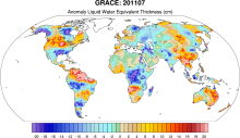 GRACE: Gravity Recovery and Climate Experiment: Surface mass, total water storage, and derived variables
Years of Record
- 2002-01 to 2012-09
The Gravity Recovery and Climate Experiment (GRACE) refers to a pair of NASA satellites that has flown in low-Earth orbit since 2002. The satellites use a precise microwave…
Main variables and Earth System components
Cryosphere Glaciers Ice Sheet Mass Land Groundwater surface water Water Storage Ocean Bottom pressure-
Timestep
- Daily, Monthly
-
Domain
- Global
-
Collections
- Diagnostic Data Sets, NCAR-DOE-CESM, landdiagnostics, landicediagnostics
Experts contributing reviews
- Swenson, Sean
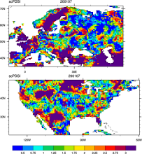 CRU sc-PDSI (self-calibrating PDSI) over Europe & North America
Years of Record
- 1901-01 to 2002-12
Maps of the monthly self-calibrating Palmer drought severity index (SCPDSI) have been calculated for the period 1901–2002 for the contiguous United States (20°–50°N and 130…
-
Formats
- ascii
-
Timestep
- Monthly
-
Domain
- Europe, North America
-
Collections
- N/A
Experts contributing reviews
- N/A
 Landscape surface freeze/thaw status based on passive microwave remote sensing
Years of Record
- 1979-01 to 2011-09
A global data set of the frozen state of the land surface (free-thaw (FT) status) has been developed spanning 1979-present at a daily timestep and 25 x 25 km spatial…
-
Timestep
- Daily
-
Domain
- Global
-
Collections
- Climate Data Record
Experts contributing reviews
- Kimball, John
 Historical land-cover changes and land-use conversions global data set by Meiyappan and Jain
Years of Record
- 1800-01 to 2010-12
A set of three estimates of land-cover types and annual transformations of land use are provided on a global 0.5°x0.5° grid at annual timesteps. The longest of the three…
Main variables and Earth System components
Land Land Cover Type Land Use Conversion Vegetation CoverExperts contributing reviews
- Meiyappan, Prasanth
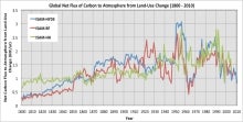 Carbon Emissions from Historical Land-Use and Land-Use Change
Years of Record
- 1800-01 to 2012-09
Annual net land-atmosphere carbon flux and net flux of carbon to the atmosphere due to land-use and land-use change (LULUC) are estimated using an integrated assessment…
Main variables and Earth System components
Biosphere CO2 Land CO2 Land-Atmosphere flux Land Cover Type Land Use ConversionExperts contributing reviews
- Meiyappan, Prasanth
 LANDSAT
Years of Record
- 1972-01 to 2013-09
"The Landsat Program provides the longest continuous space-based record of Earth’s land in existence. Since 1972, Landsat satellites have collected measurements of Earth’s…
Main variables and Earth System components
Biosphere NPP: Net Primary Production Land Land Cover Type Vegetation Cover-
Formats
- N/A
-
Timestep
- Sub-daily
-
Domain
- Global
-
Collections
- Carbon cycle
Experts contributing reviews
- N/A