MEaSUREs Northern Hemisphere Terrestrial Snow Cover Extent Daily 25km EASE-Grid 2.0
"This data set offers users 25 km Northern Hemisphere snow cover extent represented by four different variables. Three of the snow cover variables are derived from the Interactive Multisensor Snow and Ice Mapping System, MODIS Cloud Gap Filled Snow Cover, and passive microwave brightness temperatures, respectively. The fourth variable merges the three source products into a single representation of snow cover."
From the file: "This NASA MEaSUREs Earth System Data Record (ESDR) merges daily Northern Hemisphere snow cover extents over land derived from three independently produced sources. Variables include snow cover extent from the Interactive Multisensor Snow and Ice Mapping System (IMS), a gap-filled snow extent product derived from the Moderate Resolution Imaging Spectroradiometer (MODIS), and a gap-filled snow extent product derived from the Special Sensor Microwave/Imager (SSMI) and Special Sensor Microwave Imager/Sounder (SSMIS). The NSIDC Land-Ocean-Coast-Ice (LOCI) mask derived from BU-MODIS land cover data is consistently applied to each variable."
Key Strengths
See 'Citing these Data' at http://nsidc.org/data/docs/measures/nsidc-0530/index.html
Cite this page
Acknowledgement of any material taken from or knowledge gained from this page is appreciated:
National Center for Atmospheric Research Staff (Eds). Last modified "The Climate Data Guide: MEaSUREs Northern Hemisphere Terrestrial Snow Cover Extent Daily 25km EASE-Grid 2.0.” Retrieved from https://climatedataguide.ucar.edu/climate-data/measures-northern-hemisphere-terrestrial-snow-cover-extent-daily-25km-ease-grid-20 on 2026-05-22.
Citation of datasets is separate and should be done according to the data providers' instructions. If known to us, data citation instructions are given in the Data Access section, above.
Acknowledgement of the Climate Data Guide project is also appreciated:
Schneider, D. P., C. Deser, J. Fasullo, and K. E. Trenberth, 2013: Climate Data Guide Spurs Discovery and Understanding. Eos Trans. AGU, 94, 121–122, https://doi.org/10.1002/2013eo130001
Key Figures
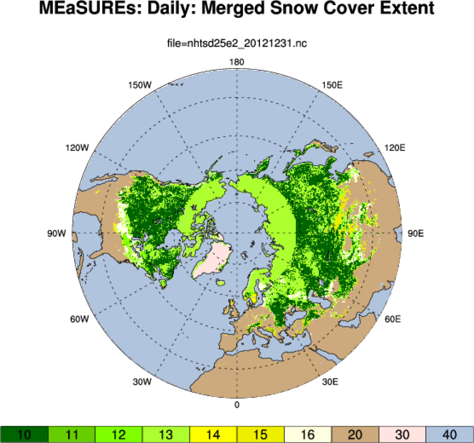
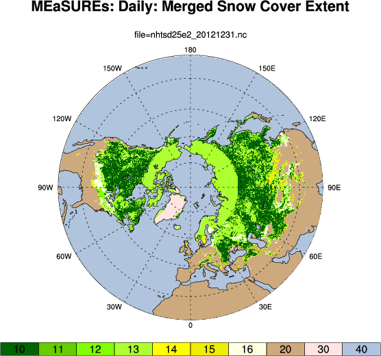
MEaSUReS: 25km: daily snow extent: Dec 31, 2012: 10: Snow cover reported by modis_cloud_gap_filled, passive_microwave, ims 11: Snow cover reported by modis_cloud_gap_filled, passive_microwave 12: Snow cover reported by modis_cloud_gap_filled, ims 13: Snow cover reported by passive_microwave, ims 14: Snow cover reported by modis_cloud_gap_filled only 15: Snow cover reported by passive_microwave only 16: Snow cover reported by ims only 20: Snow free land 30: Permanent ice covered land 40: Ocean. (D.Shea, Climate Data Guide)