Climate data guide content with tag CALIPSO
 CALIPSO
Years of record
- to
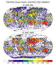
CALIPSO (Cloud-Aerosol Lidar and Infrared Pathfinder Satellite Observations ) was launched on April 28, 2006 to study the impact of clouds and aerosols on the Earth's radiation budget and climate. It flies in formation with five other satellites in the international "A-Train" constellation for coincident Earth observations. The CALIPSO satellite comprises three…
Experts contributing reviews
- N/A
 CERES EBAF: Clouds and Earth's Radiant Energy Systems (CERES) Energy Balanced and Filled (EBAF)
Years of record
- to
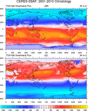
The CERES-EBAF product provides 1-degree regional, zonal and global monthly mean Top-of-Atmosphere (TOA) and surface (SFC) longwave (LW), shortwave (SW), and net (NET) fluxes under clear and all-sky conditions. EBAF is used for climate model evaluation, estimating the Earth's global mean energy budget, and to infer meridional heat transport. The data synthesized to…
Experts contributing reviews
- Loeb, Norman
 Combined CloudSat spaceborne radar and CALIPSO spaceborne lidar cloud fraction dataset (3S-GEOPROF-COMB)
Years of record
- to
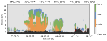
A global (82S-82N) cloud fraction data set, providing a unique view of cloud vertical structure, has been developed based on the complimentary spaceborne remote sensing capabilities of the CloudSat radar and the CALISPSO lidar. The data set provides monthly mean cloud fraction over several vertical layers for 2006-2019.
-
Formats
- netCDF
-
Timestep
- Monthly, Seasonal, Annual
-
Domain
- Global
-
Collections
- Diagnostic Data Sets, NCAR-DOE-CESM, atmosdiagnostics
Experts contributing reviews
- Bertrand, Leah, Kay, Jennifer