CLARA-A1: Cloud properties, surface albedo and surface radiation products based on AVHRR
Results are available for individual satellites (cloud properties only) as well as aggregated for all available satellites. The data are provided on two types of grids: one global regular latitude-longitude grid with 0.25 degree resolution and two equal-area grids covering the polar regions with 25 km resolution (polar products only include cloud amount and surface albedo). Further extensions (e.g. single- and multi-parameter histograms) and subsets (e.g. daytime-only and night-time only results) are also included (See Tables below)."
Key Strengths
Key Limitations
Karlsson, K.-G., Riihelä, A., Müller, R., Meirink, J.F., Sedlar, J., Stengel, M., Lockhoff, M., Trentmann, J., Kaspar, F., Hollmann, R.; Wolters, E. (2012): CLARA-A1: CM SAF cLouds, Albedo and Radiation dataset from AVHRR data - Edition 1 - Monthly Means / Daily Means / Pentad Means / Monthly Histograms. Satellite Application Facility on Climate Monitoring.
Expert Developer Guidance
The following was contributed by Martin Stengel (Deutscher Wetterdienst, Germany), May, 2013:
CLARA-A1 (CLoud, Albedo and RAdiation dataset, AVHRR-based, version 1) is a global dataset of cloud properties, surface albedo and surface radiation products, generated by the EUMETSAT Satellite Application Facility on Climate Monitoring (CM SAF). The products are derived from measurements of the Advanced Very High Resolution Radiometer (AVHRR) onboard the polar orbiting NOAA and MetOp satellites. Daily, Pentad and Monthly mean products have been compiled (depending on products) over a time period of 28 years starting in 1982 and ending in 2009. Note that radiation products are provided only from 1989.
Results are available for individual satellites (cloud properties only) as well as aggregated for all available satellites. The data are provided on two types of grids: one global regular latitude-longitude grid with 0.25 degree resolution and two equal-area grids covering the polar regions with 25 km resolution (polar products only include cloud amount and surface albedo). Further extensions (e.g. single- and multi-parameter histograms) and subsets (e.g. daytime-only and night-time only results) are also included (See Tables below).
1. Key strengths of this data set:
- Nearly 3 decades spanning global dataset of geophysical variables (daily-, pentad-, and monthly means) based on one single satellite sensor family of AVHRR with high (0.25°) spatial resolution.
- Comprehensive documentation available including a description of the algorithms used, the validation efforts performed, and important aspects for user guidance. Most important points of these documents are summarized in Karlsson et al. (2013)
- Freely available data without restrictions. Easy access: (in netcdf format, cf standard) via an interactive download facility (http://wui.cmsaf.eu)
- Very good coverage of surface (ice) albedo and cloud conditions in the Arctic and Antarctic regions during the polar summer season
- Homogeneous coverage of conditions along specific latitude bands
2. Key limitations of this data set:
- Despite efforts for inter-calibration and homogenisation, the CLARA-A1 cloud products are still not of sufficient quality to allow global climate trend analysis.
- Cloud retrievals in polar regions during polar winter conditions and for land regions with strong seasonal vegetation changes (i.e. semi-arid areas) have some shortcomings in the current dataset version.
- Polar orbiting satellites give a low frequency of observations in the tropical and sub-tropical regions
- A post-processing correction is recommended when using the surface albedo products over regions with high AOD loading.
- Surface Solar Radiation data sets are incomplete due to limited numbers of observations and retrieval problems over bright surfaces.
- The surface longwave radiation data sets are closely correlated to ERA-Interim reanalysis results.
3. Typical applications of these data:
- Climatological analysis at different temporal scales
- Model evaluation
- Solar Radiation Resource assessments
4. Common user mistakes:
- Any long term analysis using CLARA-A1 data has to take into account the inhomogeneous AVHRR sampling throughout the dataset and satellite drifting
- Neglecting the varying observation frequency with latitude (e.g., each polar orbiting satellite observes the polar areas 14 times a day while the equatorial region is only observed twice a day).
- Neglecting the variation in shortwave infrared channel (either 1.6 or 3.7 micron) available for the retrieval of cloud properties. This particularly affects LWP and IWP.
- Neglecting the use of the number of observations-data field to discard (albedo) data consisting of only a few overpasses.
- Neglecting missing data in the interpretation of spatial and temporal averages of the surface solar radiation data sets
5. Any likely spurious (non-climatic) features of timeseries derived from these data:
- Satellite drift and possible sensor degradation
- Inhomogeneities in observation frequency over the years
- Introduction of the new 1.6 micron channel on AVHRR/3, i.e. on NOAA-15 and later, which has been active instead of the 3.7 micron channel during daytime on NOAA-16 (for three years), NOAA-17 and METOP-A.
- Large variation of surface albedo over Sahara (and other high-aerosol regions). For more information, see Riihelä et al. (2013).
6. Corrections applied to account for changes in observing systems, sampling methods or density, and satellite drift or degradation:
- Intercalibration of Heidinger et al. (2010) has been applied.
- Satellite drift effects are not corrected for.
- Results are also available for morning-orbiting and afternoon-orbiting satellites in addition to the all-satellite results (for cloud products)
- The diurnal cycle of the solar radiation is considered in the temporal averaging of the surface solar radiation from the limited number of observations.
- Grid boxes (0.25°) with less than 20 observations per day were set to missing data to ensure the high and consistent quality of the surface solar radiation data.
7. Conversion steps that are necessary to compare these data with model output:
- Account for spatial and temporal sampling of the satellite, in particular for those variables which are characterized by a strong temporal and spatial variability and/or a significant diurnal cycle.
- Consider reduced sensitivity of AVHRR to optically thin clouds (0.3 optical thicknesses and below), i.e. for cloud mask/fraction and cloud top parameters.
- Account for daytime-only retrievals of liquid/ice water path, optical thickness and corresponding histograms.
- Account for missing data in the surface solar radiation data sets.
- Consider the dependency of the surface longwave radiation on the ERA-Interim reanalysis.
8. Summary statement:
- The CLARA-A1 dataset of cloud properties, surface radiation and albedo covering the period 1982 to 2009 provides the highest spatial resolution of all available global data sets. State-of-the-art retrieval schemes ensure the high quality of the retrieved geophysical parameters. Strengths and weaknesses are comprehensively documented. A ISCCP-like satellite simulator for CLARA-A1 cloud properties is currently being developed, which is envisaged to become available via the COSP framework in the near future. #
Cite this page
Acknowledgement of any material taken from or knowledge gained from this page is appreciated:
Stengel, Martin & National Center for Atmospheric Research Staff (Eds). Last modified "The Climate Data Guide: CLARA-A1: Cloud properties, surface albedo and surface radiation products based on AVHRR.” Retrieved from https://climatedataguide.ucar.edu/climate-data/clara-a1-cloud-properties-surface-albedo-and-surface-radiation-products-based-avhrr on 2026-02-24.
Citation of datasets is separate and should be done according to the data providers' instructions. If known to us, data citation instructions are given in the Data Access section, above.
Acknowledgement of the Climate Data Guide project is also appreciated:
Schneider, D. P., C. Deser, J. Fasullo, and K. E. Trenberth, 2013: Climate Data Guide Spurs Discovery and Understanding. Eos Trans. AGU, 94, 121–122, https://doi.org/10.1002/2013eo130001
Key Figures
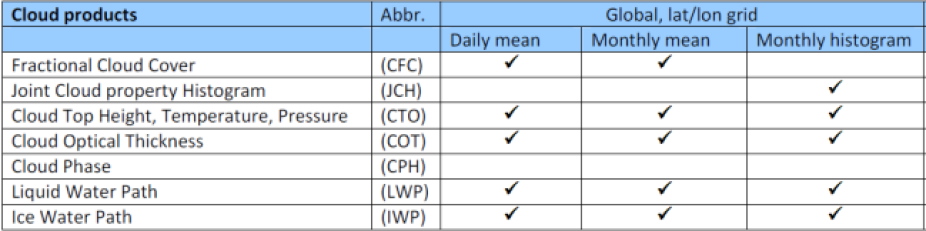
List of cloud products in CLARA-A1. Cloud products are available as merged products (including all NOAA satellites) and individual, satellite-specific products. In addition, monthly mean CFC is available for polar regions on an equal area grid. Contributed by M. Stengel.

List of radiation and albedo products in CLARA-A1. In addition, pentad and monthly mean albedo is available for polar regions on an equal area grid. Contributed by M. Stengel.

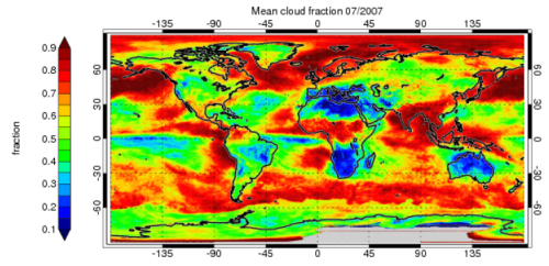
Monthly mean cloud fractional coverage. (Figure taken from Karlsson et al. (2013)). Contributed by M. Stengel.
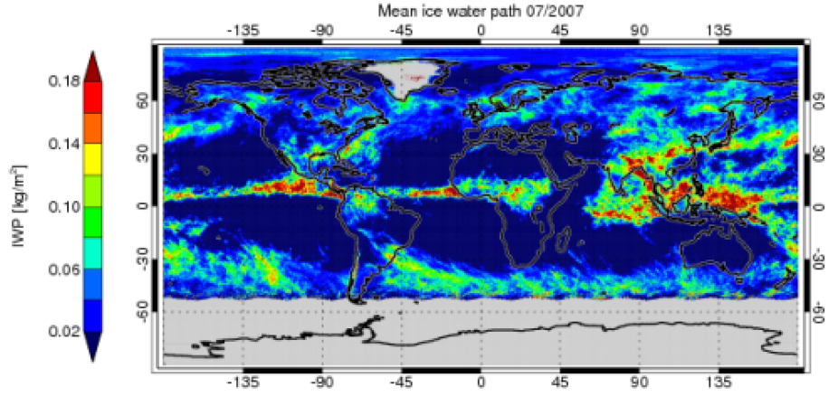
Monthly mean ice water path (Figure taken from Karlsson et al. (2013)). Contributed by M. Stengel.

Joint Cloud property Histograms (JCH) for March 2004 for liquid clouds (left) and ice clouds (right). Contributed by M. Stengel.
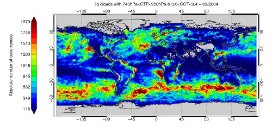
Based on the JCH, a global map of absolute occurrences of liquid cloud with cloud-top pressure between 740 and 950hPa and cloud optical thickness between 3.6 and 9.4. Contributed by M. Stengel.

Example of surface albedo (SAL) for the polar products with left: Arctic and right: Antarctic (Figure taken from Karlsson et al. (2013)). Contributed by M. Stengel.
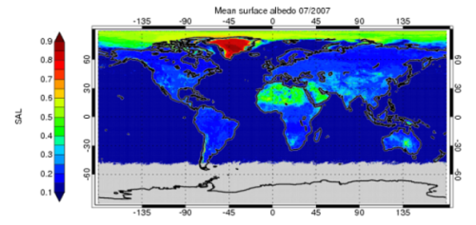
Monthly mean surface albedo (Figure taken from Karlsson et al. (2013)). Contributed by M. Stengel.

Example of Surface Irradiance (SIS) for July 2007. Contributed by M. Stengel.
Other Information
- Karlsson, K.-G., an coauthors, 2013: CLARA-A1: the CM SAF cloud, albedo and radiation dataset from 28 yr of global AVHRR data, Atmos. Chem. Phys. Discuss., 13, 935-982.
- Riihelä, A., Manninen, T., Laine, V., Andersson, K., and Kaspar, F.: CLARA-SAL: a global 28 yr timeseries of Earth's black-sky surface albedo, Atmos. Chem. Phys., 13, 3743-3762, doi:10.5194/acp-13-3743-2013, 2013.