Freshwater Discharge: 1948-2004
"A dataset of historical monthly streamflow at the farthest downstream stations for the world’s 925 largest ocean-reaching rivers has been created for community use. Compared with previous studies, the new dataset has improved homogeneity and enables more reliable assessments of decadal and long-term changes in continental freshwater discharge into the oceans." The data are in the form of time series.
Cite this page
Acknowledgement of any material taken from or knowledge gained from this page is appreciated:
National Center for Atmospheric Research Staff (Eds). Last modified "The Climate Data Guide: Freshwater Discharge: 1948-2004.” Retrieved from https://climatedataguide.ucar.edu/climate-data/freshwater-discharge-1948-2004 on 2026-02-19.
Citation of datasets is separate and should be done according to the data providers' instructions. If known to us, data citation instructions are given in the Data Access section, above.
Acknowledgement of the Climate Data Guide project is also appreciated:
Schneider, D. P., C. Deser, J. Fasullo, and K. E. Trenberth, 2013: Climate Data Guide Spurs Discovery and Understanding. Eos Trans. AGU, 94, 121–122, https://doi.org/10.1002/2013eo130001
Key Figures
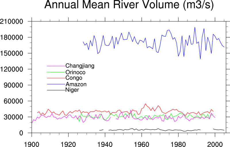
Annual mean fresh water discharge rom assorted river basins. (Climate Data Guide; D. Shea)
Other Information
- Animation: Dai, A., T. Qian, K. E. Trenberth, and J. D Milliman, 2009: Changes in continental freshwater discharge from 1948-2004. J. Climate, 22, 2773-2791
- Dai, A., T. Qian, K. E. Trenberth, and J. D Milliman, 2009: Changes in continental freshwater discharge from 1948-2004. J. Climate, 22, 2773-2791
- Dai, A., and K. E. Trenberth, 2002: Estimates of freshwater discharge from continents: Latitudinal and seasonal variations. J. Hydrometeorol., 3, 660-687.