Climate data guide content with tag Land
 An overview of paleoclimate information from high-resolution lake sediment records: Strengths, limitations and key databases
Years of record
- N/A
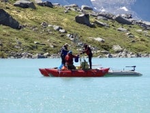
Accumulated sediments at the bottom of lakes are invaluable archives of past climate and environmental change. These sediments contain a variety of physical, geochemical, and biological proxy indicators that can be used to gain a multi-faceted understanding of past conditions. Unlike other high-resolution paleoclimate archives, such as tree rings, corals, and…
Main variables and Earth System components
Atmosphere Air Temperature Precipitation Biosphere Pollen Land-
Formats
- ascii, csv, Linked Paleo Data (LiPD)
-
Timestep
- Annual, Decadal, Irregular
-
Domain
- Global
-
Collections
- N/A
Experts contributing reviews
- Larocca, Laura, Broadman, Ellie
 Arctic System Reanalysis (ASR)
Years of record
- to
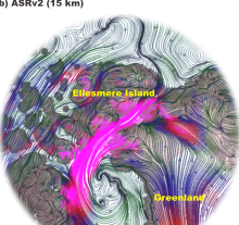
The Arctic System Reanalysis is a multi-agency, university-led retrospective analysis (reanalysis) of the Greater Arctic. ASR is produced using high-resolution versions of the Polar Weather Forecast Model (PWRF) and the WRF-VAR and High Resolution Land Data Assimilation (HRLDAS) data assimilation systems that have been optimized for the Arctic. ASR is a comprehensive…
Experts contributing reviews
- N/A
 CAM6+DART Reanalysis and Surface Forcings
Years of record
The CAM6+DART (Community Atmospheric Model version 6 + Data Assimilation Research Testbed) Reanalysis is an 80-member global atmospheric reanalysis with 6 hourly output from 2011-2020 on an approximately 1° lon-lat grid. This ensemble has two major features making it useful for model development and research. First, the 80 member ensemble is constructed to effectively…
-
Formats
- N/A
-
Timestep
- Sub-daily, Weekly
-
Domain
- Global
-
Collections
- Boundary Conditions
Experts contributing reviews
- Raeder, Kevin
 Carbon Emissions from Historical Land-Use and Land-Use Change
Years of record
- to
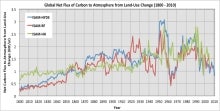
Annual net land-atmosphere carbon flux and net flux of carbon to the atmosphere due to land-use and land-use change (LULUC) are estimated using an integrated assessment model and three historical reconstructions of land use and land use conversion. The data span 1800-2010 and are aggregated for nine regions of the globe.
Main variables and Earth System components
Biosphere CO2 Land CO2 Land-Atmosphere flux Land Cover Type Land Use ConversionExperts contributing reviews
- Meiyappan, Prasanth
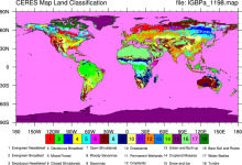 CERES: IGBP Land Classification
Years of record
- N/A
The International Geosphere–Biosphere Programme (IGBP) defines ecosystems surface classifications. The CERES (Clouds and Earth's Radiant Energy System)10-minute data can be used to derive the land categories.
Experts contributing reviews
- N/A
 COREv2 Air-Sea Surface Fluxes
Years of record
- to
The Coordinated Ocean Research Experiments version 2 (COREv2) data set consists of a globally complete set of air-sea fluxes of momentum, heat and freshwater for 1948-2009 at monthly resolution. This data set serves as a set of common atmospheric boundary conditions that has been used by the ocean modeling community to force and compare a diverse set of…
Main variables and Earth System components
Atmosphere Evaporation Precipitation Radiation Wind Stress Land Runoff and Streamflow Ocean Surface Flux-
Formats
- netCDF
-
Timestep
- Monthly
-
Domain
- Global
-
Collections
- Diagnostic Data Sets, NCAR-DOE-CESM, atmosdiagnostics, oceandiagnostics
Experts contributing reviews
- Yeager, Stephen
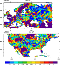 CRU sc-PDSI (self-calibrating PDSI) over Europe & North America
Years of record
- to
Maps of the monthly self-calibrating Palmer drought severity index (SCPDSI) have been calculated for the period 1901–2002 for the contiguous United States (20°–50°N and 130°–60°W) and Europe (35°–70°N, 10°W–60°E) with a spatial resolution of 0.5° × 0.5°
-
Formats
- ascii
-
Timestep
- Monthly
-
Domain
- Europe, North America
-
Collections
- N/A
Experts contributing reviews
- N/A
 Drought atlases from tree rings
Years of record
- to
Tree-ring drought atlases provide a paleoclimate analog to modern drought indices, most commonly the Palmer Drought Severity Index (PDSI). Produced on a regular lat-lon grid for regions such as North America, Europe, and Australia, these centuries-long datasets are convenient for comparisons with climate model experiments and historical data on human populations…
-
Timestep
- Annual
-
Domain
- North America
-
Collections
- N/A
Experts contributing reviews
- Cook, Edward
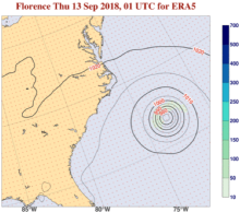 ERA5 atmospheric reanalysis
Years of record
- to
ERA5, the successor to ERA-Interim, provides global, hourly estimates of atmospheric, ocean-wave and land-surface variables, at a horizontal resolution of 31 km and 137 levels in the vertical from the surface to 0.01 hPa (about 80km). Produced by ECMWF on behalf of the European Union’s Copernicus Climate Change Service (C3S), ERA5 extends from 1940 onwards. Each day one…
-
Timestep
- Sub-daily, Daily, Monthly
-
Domain
- Global
-
Collections
- Diagnostic Data Sets
Experts contributing reviews
- Hersbach, Hans
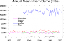 Freshwater Discharge: 1948-2004
Years of record
- to
"A dataset of historical monthly streamflow at the farthest downstream stations for the world’s 925 largest ocean-reaching rivers has been created for community use. Compared with previous studies, the new dataset has improved homogeneity and enables more reliable assessments of decadal and long-term changes in continental freshwater discharge into the oceans." The data…
-
Timestep
- Monthly
-
Domain
- Global
-
Collections
- Climate Analysis Section (CAS) Data Catalog
Experts contributing reviews
- N/A
 GHCNDEX: Gridded Temperature and Precipitation Climate Extremes Indices (CLIMDEX data)
Years of record
- to
GHCNDEX provides gridded, station-based indices of temperature- and precipitation- related climate extremes. It is intended for detection and attribution studies, climate model evaluation, and operational monitoring of extreme climatic events. Twenty-six indices, including daily maximum and minimum temperatures, number of frost days, maximum 1-day precipitation, and…
Main variables and Earth System components
Atmosphere Maximum Air Temperature Minimum Air Temperature Land Freeze/ThawExperts contributing reviews
- N/A
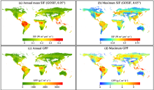 Global dataset of solar-induced chlorophyll fluorescence (GOSIF)
Years of record
- to
GOSIF is a global, gridded dataset of solar-induced chlorophyll fluorescence (SIF). SIF, an energy flux re-emitted by plants a few nanoseconds after light absorption, exhibits a strong linear relationship with gross primary production (GPP) at the ecosystem scale and thereby is a strong proxy of GPP. The GOSIF dataset (Li and Xiao, 2019a) provides 8-day SIF data…
Main variables and Earth System components
Biosphere GPP: Gross Primary Production solar-induced chlorophyll fluorescence (SIF) Land Gross Primary Production-
Formats
- N/A
-
Timestep
- Monthly, Weekly
-
Domain
- Global
-
Collections
- N/A
Experts contributing reviews
- Xiao, Jingfeng, Li, Xing
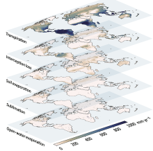 Global Land Evaporation Amsterdam Model (GLEAM)
Years of record
- to
The Global Land Evaporation Amsterdam Model (GLEAM) is a satellite remote sensing-based set of algorithms dedicated to the estimation of evaporation and soil moisture at global scales (Miralles et al. 2011). The current version of GLEAM (version 3) operates at a daily time step with a spatial resolution of 0.25 degrees (Martens et al. 2017). The dataset consists of two…
Main variables and Earth System components
Biosphere land evaporation Land evapotranspiration Soil Moisture-
Formats
- N/A
-
Timestep
- Daily
-
Domain
- Global
-
Collections
- N/A
Experts contributing reviews
- Miralles, Diego, Koppa, Akash
 Global Permafrost Zonation Index Map
Years of record
- N/A
This data set contains a global (excluding Antarctica) 1 km map of permafrost zonation. It is an estimate of to what degree permafrost exists in a region nearly everywhere, or only in the most favorable conditions. These local conditions affecting permafrost occurrence will partly exhibit regional trends (e.g. mean snow cover characteristics or continentality), partly…
Experts contributing reviews
- Gruber, Stephan
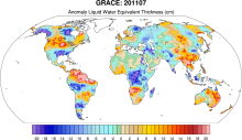 GRACE: Gravity Recovery and Climate Experiment: Surface mass, total water storage, and derived variables
Years of record
- to
The Gravity Recovery and Climate Experiment (GRACE) refers to a pair of NASA satellites that has flown in low-Earth orbit since 2002. The satellites use a precise microwave ranging system to measure the distance between themselves due to gravitational acceleration. Onboard GPS instruments determine the exact position of the satellites over the Earth. GRACE measures…
Main variables and Earth System components
Cryosphere Glaciers Ice Sheet Mass Land Groundwater surface water Water Storage Ocean Bottom pressure-
Timestep
- Daily, Monthly
-
Domain
- Global
-
Collections
- Diagnostic Data Sets, NCAR-DOE-CESM, landdiagnostics, landicediagnostics
Experts contributing reviews
- Swenson, Sean
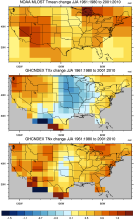
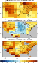 HadEX2: Gridded Temperature and Precipitation Climate Extremes Indices (CLIMDEX data)
Years of record
- to
Note: HadEX2 has been superseded by HadEX3. HadEX2 provides gridded, station-based indices of temperature- and precipitation- related climate extremes. It is intended for detection and attribution studies and climate model evaluation. Twenty-nine indices, including daily maximum and minimum temperatures, number of frost days, maximum 1-day precipitation, and growing…
Main variables and Earth System components
Atmosphere Maximum Air Temperature Minimum Air Temperature Land Freeze/ThawExperts contributing reviews
- N/A
 HadEX3: Gridded Temperature and Precipitation Climate Extremes Indices (CLIMDEX data)
Years of record
- to
HadEX3 provides gridded, station-based indices of temperature- and precipitation- related climate extremes and supersedes HadEX2. It is intended for global and continental climate monitoring, detection and attribution studies and climate model evaluation. Twenty-nine indices, including daily maximum and minimum temperatures, number of frost days, maximum 1-day…
Main variables and Earth System components
Atmosphere Air Temperature at 2m Maximum Air Temperature Minimum Air Temperature Land Freeze/ThawExperts contributing reviews
- Dunn, Robert
 Historical land-cover changes and land-use conversions global data set by Meiyappan and Jain
Years of record
- to
A set of three estimates of land-cover types and annual transformations of land use are provided on a global 0.5°x0.5° grid at annual timesteps. The longest of the three estimates spans 1770-2010. The three estimates use three different data sets of cropland and pastureland. Common input data sets are of wood harvest and urban land. The three estimates use a consistent…
Main variables and Earth System components
Land Land Cover Type Land Use Conversion Vegetation CoverExperts contributing reviews
- Meiyappan, Prasanth
 Lake Water Storage: GloLakes
Years of record
- to
Lakes and reservoirs are critical components of the hydrological cycle, particularly due to their central role in many human systems. Long-term measurements of lakes is critical for understanding the dynamics linking lake volume to the climate system and human activities. The GloLakes dataset utilities remote sensing data to provide near real-time monitoring of the…
-
Formats
- N/A
-
Timestep
- Monthly
-
Domain
- Global
-
Collections
- BAMS State of the Climate
Experts contributing reviews
- N/A
 LANDSAT
Years of record
- to
"The Landsat Program provides the longest continuous space-based record of Earth’s land in existence. Since 1972, Landsat satellites have collected measurements of Earth’s continents and surrounding coastal regions that have enabled people to study forests, food production, water and land use, ecosystems, geology, and more. The long data record allows scientists to…
Main variables and Earth System components
Biosphere NPP: Net Primary Production Land Land Cover Type Vegetation Cover-
Formats
- N/A
-
Timestep
- Sub-daily
-
Domain
- Global
-
Collections
- Carbon cycle
Experts contributing reviews
- N/A
 Landscape surface freeze/thaw status based on passive microwave remote sensing
Years of record
- to
A global data set of the frozen state of the land surface (free-thaw (FT) status) has been developed spanning 1979-present at a daily timestep and 25 x 25 km spatial resolution. Based on passive microwave remote sensing, the FT parameter is closely related to the surface energy budget, hydrologic cycle, trace gas exchanges, vegetation growth, and terrestrial carbon…
-
Timestep
- Daily
-
Domain
- Global
-
Collections
- Climate Data Record
Experts contributing reviews
- Kimball, John
 Making sense of data from Land Surface Models (LSMs)
Years of record
- N/A
The land surface is a dynamic and complex component of the Earth system, shaping climate and biogeochemical cycles and serving as the origin of many anthropogenic impacts on the planet. Comprising complex and interactive organic and inorganic systems (soils, rocks, water in all phases, vegetation, and animals) the land surface shapes and is shaped by the fluid envelope…
-
Formats
- N/A
-
Timestep
- N/A
-
Domain
- N/A
-
Collections
- N/A
Experts contributing reviews
- Mankin, Justin, Lesk, Corey
 NCEP NARR
Years of record
- to
A high resolution (32km x 29 pressure levels) data set focused upon the North American Region. Relative to the NCEP-DOE (R2) it has a much improved land-hydrology, diurnal cycle and land-atmosphere interaction. As such, it can be considered a second generation reanalysis. A unique feature is the direct assimilation of observed precipitation.
Main variables and Earth System components
Atmosphere Air Temperature Geopotential Height Precipitable water Land-
Formats
- GRIB
-
Timestep
- Climatology, Sub-daily, Monthly
-
Domain
- North America
-
Collections
- N/A
Experts contributing reviews
- N/A
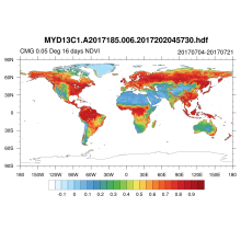 NDVI and EVI: Vegetation Indices (MODIS)
Years of record
- to
MODIS vegetation indices, produced on 16-day and monthly intervals and at multiple spatial resolutions, provide consistent spatial and temporal comparisons of vegetation canopy greenness, a composite property of leaf area, chlorophyll and canopy structure. Two vegetation indices are derived from atmospherically-corrected reflectance in the red, near-infrared, and blue…
Main variables and Earth System components
Land Enhanced Vegetation Index (EVI) NDVI" Normalized Difference Vegetation IndexExperts contributing reviews
- N/A
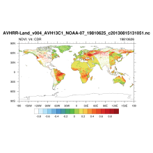 NDVI: Normalized-difference-vegetation-index: NOAA AVHRR
Years of record
- to
Normalized Difference Vegetation Index (NDVI) values are derived from surface reflectance data acquired by the Advanced Very High Resolution Radiometer (AVHRR) sensor. By applying knowledge gathered over time about instrument performance and sensor characteristics, the data are reprocessed to create consistent long-term records, allowing insight into changes in the…
Experts contributing reviews
- N/A
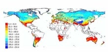
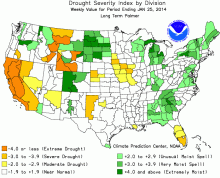 Palmer Drought Severity Index (PDSI)
Years of record
- N/A
The Palmer Drought Severity Index (PDSI) uses readily available temperature and precipitation data to estimate relative dryness. It is a standardized index that generally spans -10 (dry) to +10 (wet). Maps of operational agencies like NOAA typically show a range of -4 to +4, but more extreme values are possible. The PDSI has been reasonably successful at quantifying…
-
Timestep
- Monthly
-
Domain
- Global
-
Collections
- Climate Analysis Section (CAS) Data Catalog
Experts contributing reviews
- Dai, Aiguo, Bui, Sang, Lenssen, Nathan
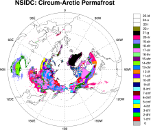 Permafrost: Circum-Arctic Map of Permafrost and Ground Ice Conditions
Years of record
- N/A
The circumpolar permafrost and ground ice data contribute to a unified international data set that depicts the distribution and properties of permafrost and ground ice in the Northern Hemisphere (20°N to 90°N). The re-gridded data set shows discontinuous, sporadic, or isolated permafrost boundaries.
-
Timestep
- Climatology
-
Domain
- NH - Northern Hemisphere
-
Collections
- N/A
Experts contributing reviews
- N/A
 Randolph Glacier Inventory data base of global glacier outlines
Years of record
- N/A
The Randolph Glacier Inventory (RGI) is a global data base of glacier outlines. It is intended for estimates of ice volume and glacier mass at regional and global scales. The data are organized into 19 large regions, with a shapefile provided for each region. The RGI is produced as part of the Global Land Ice Measurements from Space (GLIMS) initiative, a project to…
Experts contributing reviews
- N/A
 SMAP-Derived 1-km Downscaled Surface Soil Moisture
Years of record
- to
This data product contains global daily 1 km resolution surface soil moisture (SM) derived from the Soil Moisture Active Passive (SMAP) L-band radiometer observations. Specifically, Moderate Resolution Imaging Spectroradiometer (MODIS) land surface temperature and Normalized Difference Vegetation Index (NDVI) data were used with the SMAP Enhanced L2 radiometer Half-…
-
Formats
- N/A
-
Timestep
- Daily
-
Domain
- Global
-
Collections
- N/A
Experts contributing reviews
- Lakshmi, Venkataraman, Fang, Bin
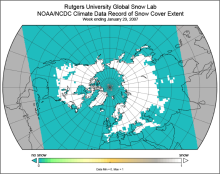 Snow Cover Extent (Northern Hemisphere) Climate Data Record, by Rutgers
Years of record
- to
The Snow Cover Extent Climate Data Record extends from the late 1960s to present. Historical analyses based on visual inspection have been digitized and combined with modern multi-spectral remote sensing to produce a seamless record on a hemispheric scale. The data are available at weekly and monthly resolutions in a variety of formats. The spatial resolution varies with…
-
Timestep
- Monthly, Weekly
-
Domain
- North America
-
Collections
- Climate Data Record, Diagnostic Data Sets, NCAR-DOE-CESM, landdiagnostics
Experts contributing reviews
- Estilow, Thomas W., Robinson, David
 Soil Moisture Data Sets: Overview & Comparison Tables
Years of record
- N/A
Soil moisture is a state variable of the land that crosses the interfaces of several disciplines, including meteorology, hydrology, climatology and ecology. Soil moisture content controls the partitioning of net radiation at the land surface between sensible and latent heat fluxes. This occurs primarily in the subtopics and tropics where rainfall is not abundant, and in…
-
Formats
- N/A
-
Timestep
- N/A
-
Domain
- N/A
-
Collections
- Overview / Comparison page
Experts contributing reviews
- Dirmeyer, Paul
 Standardized Precipitation Index (SPI)
Years of record
- to
The Standardized Precipitation Index (SPI) is a widely used index to characterize meteorological drought on a range of timescales. On short timescales, the SPI is closely related to soil moisture, while at longer timescales, the SPI can be related to groundwater and reservoir storage. The SPI can be compared across regions with markedly different climates. It quantifies…
-
Formats
- N/A
-
Timestep
- Monthly
-
Domain
- N/A
-
Collections
- N/A
Experts contributing reviews
- Keyantash, John
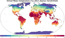 TerraClimate: Global, high-resolution gridded temperature, precipitation, and other water balance variables
Years of record
- to
TerraClimate is a global gridded dataset of meteorological and water balance variables for 1958-present, available on a monthly timestep. Its relatively fine spatial resolution, global extent, and long length are a unique combination that fills a void in climate data. TerraClimate combines spatial climatology from WorldClim with time-varying information from the…
Main variables and Earth System components
Atmosphere Air Temperature Maximum Air Temperature Minimum Air Temperature Potential Evapotranspiration Precipitation Wind Snow Water Equivalent Land evapotranspiration Runoff and Streamflow Soil MoistureExperts contributing reviews
- Abatzoglou, John
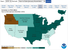 U.S. Climate Extremes Index (CEI)
Years of record
- to
The U.S. Climate Extremes Index (CEI) was first presented in 1995 as a framework for quantifying observed changes in climate within the contiguous United States. At present, the CEI evaluates the percent area of extremes in the distribution of much above/below average (top/bottom 10% of occurrence) temperatures, precipitation, drought, and tropical cyclone wind…
Main variables and Earth System components
Atmosphere Air Temperature Maximum Air Temperature Minimum Air Temperature Precipitation Wind Land Drought-
Formats
- ascii
-
Timestep
- Monthly, Seasonal, Annual
-
Domain
- North America
-
Collections
- N/A
Experts contributing reviews
- Gleason, Karin