Global Permafrost Zonation Index Map
Key Strengths
Key Limitations
Expert Developer Guidance
The following was contributed by Stephan Gruber (U Zurich), April, 2012:
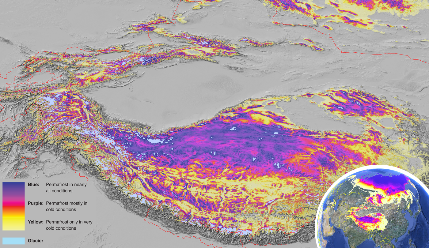
This data set contains a global (excluding Antarctica) 1 km map of permafrost zonation. The accompanying publicatios points out important limitations that exist in such products and that may be relevant when used for validating other models. The Permafrost Zonation Index (PZI) or a corresponding map color indicates, to what degree permafrost exists only in the most favorable conditions (yellow) or nearly everywhere (blue). These local conditions affecting permafrost occurrence will partly exhibit regional trends (e.g. mean snow cover characteristics or continentality), partly vary over typical distances on the order of several km (e.g. shaded or sun-exposed side of a mountain), and partly over tens to hundreds of meters (e.g. snow drift, vegetation, ground material). These conditions need to be assessed during interpretation, depending on the intended purpose of using the PZI map. This product is likely to be most valuable in remote regions where only sparse reliable information exists. The accompanying publication [Key Publication #1 below, Gruber et al., 2012] points to the importance of heterogeneity and uncertainty in the derivation and use of such permafrost zonation maps.#
Cite this page
Acknowledgement of any material taken from or knowledge gained from this page is appreciated:
Gruber, Stephan & National Center for Atmospheric Research Staff (Eds). Last modified "The Climate Data Guide: Global Permafrost Zonation Index Map.” Retrieved from https://climatedataguide.ucar.edu/climate-data/global-permafrost-zonation-index-map on 2026-02-10.
Citation of datasets is separate and should be done according to the data providers' instructions. If known to us, data citation instructions are given in the Data Access section, above.
Acknowledgement of the Climate Data Guide project is also appreciated:
Schneider, D. P., C. Deser, J. Fasullo, and K. E. Trenberth, 2013: Climate Data Guide Spurs Discovery and Understanding. Eos Trans. AGU, 94, 121–122, https://doi.org/10.1002/2013eo130001
Key Figures

Permafrost Zonation in the Himalaya region. (Credit: Stephan Gruber [U Zurich])