RAPID: monitoring the Atlantic Meridional Overturning Circulation at 26.5°N
"A principal objective of the RAPID programme is the development and maintenance of a pre-operational prototype system that will continuously observe the strength and structure of the MOC. An initiative has been formed to fulfill this objective and consists of three interlinked projects:
- Nineteen moorings were deployed in March 2004 across the Atlantic at 26.5°N to measure the southward branch of the MOC (Hirschi et al., 2003, Baehr et al., 2004, Cunningham et al., 2007, Kanzow et al., 2007) .
- Additional moorings were deployed on the western boundary along 26.5°N in the framework of the U.S. Meridional Overturning Circulation and Heatflux Array (MOCHA) project (Prof. Bill Johns, University of Miami) to resolve transport in the Deep Western Boundary Current (Johns et al., 2005, 2008, Bryden et al., 2005). These moorings allow surface-to-bottom density profiles along the western boundary, Mid-Atlantic Ridge, and eastern boundary to be observed. As a result, the transatlantic pressure gradient can be continuously measured.
- Dr Molly Baringer (NOAA/AOML) leads the monitoring of the northward branch of the MOC using submarine telephone cables in the Florida Straits (Baringer et al., 2001)."
An updated and extended suite of time series was released in November 2017. Some small changes were made in the calculation of the MOC. These are described in the ‘Readme' file which may be dowloaded from the WWW. This updated dataset supersedes the previous release.
"Data from the RAPID-WATCH MOC monitoring project are funded by the Natural Environment Research Council and are freely available from www.rapid.ac.uk/rapidmoc."
RAPID-MOCHA: "Data from the RAPID-MOCHA program are funded by the U.S. National Science Foundation and U.K. Natural Environment Research Council and are freely available at www.noc.soton.ac.uk/rapidmoc and www.rsmas.miami.edu/users/mocha."
Cite this page
Acknowledgement of any material taken from or knowledge gained from this page is appreciated:
National Center for Atmospheric Research Staff (Eds). Last modified "The Climate Data Guide: RAPID: monitoring the Atlantic Meridional Overturning Circulation at 26.5°N.” Retrieved from https://climatedataguide.ucar.edu/climate-data/rapid-monitoring-atlantic-meridional-overturning-circulation-265%25C2%25B0n on 2026-07-07.
Citation of datasets is separate and should be done according to the data providers' instructions. If known to us, data citation instructions are given in the Data Access section, above.
Acknowledgement of the Climate Data Guide project is also appreciated:
Schneider, D. P., C. Deser, J. Fasullo, and K. E. Trenberth, 2013: Climate Data Guide Spurs Discovery and Understanding. Eos Trans. AGU, 94, 121–122, https://doi.org/10.1002/2013eo130001
Key Figures

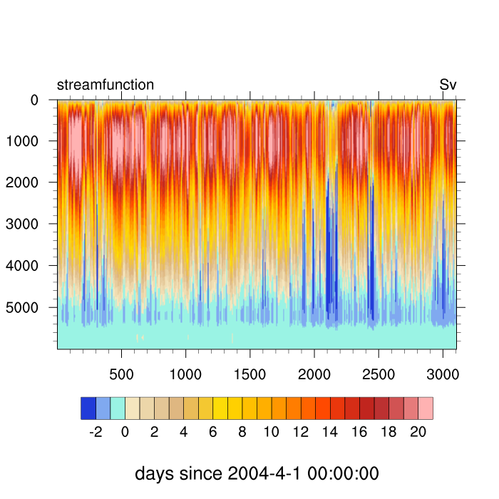
Streamfunction (Sv) from downloaded netCDF file: moc_vertical.nc. The left scale is depth (m). (Climate Data Guide; D. Shea)