Climate data guide content with tag Ocean
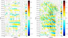
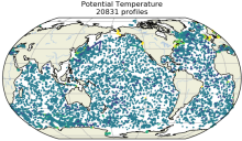
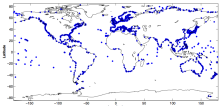
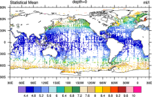
 Argo Ocean Temperature and Salinity Profiles
Years of record
- to
Argo is an array of over 4100 profiling floats distributed almost uniformly across the global oceans. First deployed in 2000, Argo floats provide temperature and salinity profiles from the surface to a depth of 2000m. The array has approximately 1 float for every 3 degrees of latitude and longitude, providing a new profile once every 10 days. 'Real-time' data…
Main variables and Earth System components
Ocean Salinity Sub Surface Salinity Sub Surface TemperatureExperts contributing reviews
- Scanderbeg, Megan, Purkey, Sarah, Willis, Josh
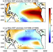 Asymmetry and Diversity in the pattern, amplitude and duration of El Niño and La Niña
Years of record
- N/A
El Niño and La Niña, the two phases of ENSO, are sometimes described as opposites. However, there are asymmetries in their spatial structure, amplitude, duration and seasonal evolution. This leads to differing teleconnections and global impacts, as well as implications for ENSO predictability. The 'Expert Guidance' section of this post summarizes the metrics used to…
-
Formats
- N/A
-
Timestep
- N/A
-
Domain
- Tropics
-
Collections
- N/A
Experts contributing reviews
- Santoso, Agus
 Atlantic Multi-decadal Oscillation (AMO) and Atlantic Multidecadal Variability (AMV)
Years of record
- to
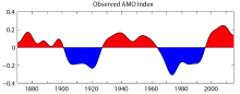
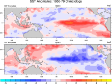
The Atlantic Multi-decadal Oscillation (AMO) has been identified as a coherent mode of natural variability occurring in the North Atlantic Ocean with an estimated period of 60-80 years. It is based upon the average anomalies of sea surface temperatures (SST) in the North Atlantic basin, typically over 0-80N. To remove the signal of long-term change from the AMO…
-
Timestep
- Monthly, Decadal
-
Collections
- Climate Analysis Section (CAS) Data Catalog
Experts contributing reviews
- Trenberth, Kevin, Zhang, Rong
 AVISO: Satellite derived Sea Surface Height above Geoid
Years of record
- to
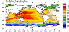
The sea surface height relative to the geoid (the mean ocean surface of the Earth if the ocean is at rest) is derived from TOPEX/Poseidon, Envisat, Jason-1, and OSTM/Jason-2 altimetry measurements. Altimetry is a technique for measuring height. Satellite altimetry measures the time taken by a radar pulse to travel from the satellite antenna to the surface and back to…
Experts contributing reviews
- N/A
 CARINA: Carbon in the North Altantic
Years of record
- to
The CARINA (CARbon dioxide IN the Atlantic Ocean) data synthesis project is an international collaborative effort of the EU IP CARBOOCEAN, and US partners. It has produced a merged internally consistent data set of open ocean subsurface measurements for biogeochemical investigations, in particular, studies involving the carbon system. The original focus area was the…
-
Formats
- ascii
-
Timestep
- Sub-daily
-
Domain
- Arctic, Atlantic Ocean, Southern Ocean
-
Collections
- Carbon cycle
Experts contributing reviews
- N/A
 CERA-20C: ECMWF's Coupled Ocean-Atmosphere Reanalysis of the 20th Century
Years of record
- to
The CERA-20C is a global, coupled reanalysis spanning 1901-2010 with a focus on low-frequency climate variability. Similar to ERA-20C, the surface observations assimilated include surface pressures from the International Surface Pressure Databank v3.2.6 and ICOADS v 2.5.1, and surface winds over the oceans from ICOADSv2.5.1. Upper-air and satellite data are…
Main variables and Earth System components
Atmosphere Multiple variables Cryosphere Sea Ice Concentration OceanExperts contributing reviews
- Laloyaux, Patrick
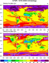 Climate Forecast System Reanalysis (CFSR)
Years of record
- to
The CFSR is a third generation reanalysis product. It is a global, high resolution, coupled atmosphere-ocean-land surface-sea ice system designed to provide the best estimate of the state of these coupled domains over this period. The CFSR includes (1) coupling of atmosphere and ocean during the generation of the 6 hour guess field, (2) an interactive sea-ice model, and…
Main variables and Earth System components
Atmosphere Air Temperature Geopotential Height Precipitable water Ocean-
Formats
- GRIB
-
Timestep
- Sub-daily, Monthly
-
Domain
- Global
-
Collections
- Climate Analysis Section (CAS) Data Catalog
Experts contributing reviews
- N/A
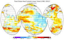 CMCC Global Ocean Reanalysis System (C-GLORS)
Years of record
- to
"The CMCC Global Ocean Physical Reanalysis System (C-GLORS) is used to simulate the state of the ocean in the last decades. It consists of a variational data assimilation system (OceanVar), capable of assimilating all in-situ observations along with altimetry data, and a forecast step performed by the ocean model NEMO coupled with the LIM2 sea-ice model…
Main variables and Earth System components
Ocean Ocean Heat Content SST - sea surface temperature Salinity Sub Surface Salinity Sub Surface Temperature mixed layer depth sea surface height u, v current componentsExperts contributing reviews
- Storto, Andrea
 Coral geochemical records: An overview of their use as climate proxies and of available databases
Years of record
- N/A
Coral records are one of the main types of high-resolution (annual to sub-annual) paleoclimate proxies, providing timeseries of environmental conditions reaching hundreds to thousands of years into the past in the tropics, the central driver of the global atmospheric circulation. As such, corals complement paleoclimate records from the largely mid-latitude tree-…
Main variables and Earth System components
Atmosphere Evaporation Evaporation-Precipitation Precipitation Ocean Salinity SST - sea surface temperature-
Formats
- ascii, HTML Table, Linked Paleo Data (LiPD), Matlab
-
Timestep
- N/A
-
Domain
- Atlantic Ocean, Indian Ocean, Pacific Ocean, Tropics
-
Collections
- N/A
Experts contributing reviews
- Lawman, Allison
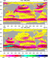 COREv2 Air-Sea Surface Fluxes
Years of record
- to
The Coordinated Ocean Research Experiments version 2 (COREv2) data set consists of a globally complete set of air-sea fluxes of momentum, heat and freshwater for 1948-2009 at monthly resolution. This data set serves as a set of common atmospheric boundary conditions that has been used by the ocean modeling community to force and compare a diverse set of…
Main variables and Earth System components
Atmosphere Evaporation Precipitation Radiation Wind Stress Land Runoff and Streamflow Ocean Surface Flux-
Formats
- netCDF
-
Timestep
- Monthly
-
Domain
- Global
-
Collections
- Diagnostic Data Sets, NCAR-DOE-CESM, atmosdiagnostics, oceandiagnostics
Experts contributing reviews
- Yeager, Stephen
 EN4 subsurface temperature and salinity for the global oceans
Years of record
- to
EN4 is a subsurface temperature and salinity dataset for the global oceans, spanning 1900 to present at a monthly timestep. It includes two types of data products: (1) a database of quality-controled in situ profiles and (2) a spatially complete analyses at 1 by 1 degree horizontal resolution and 42 depth levels for 83S to 90N. Input data include Argo (Argo, 2000), ASBO…
Main variables and Earth System components
Ocean potential temperature Sub Surface Salinity Sub Surface Temperature Sub-surface dataExperts contributing reviews
- Killick, Rachel
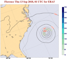 ERA5 atmospheric reanalysis
Years of record
- to
ERA5, the successor to ERA-Interim, provides global, hourly estimates of atmospheric, ocean-wave and land-surface variables, at a horizontal resolution of 31 km and 137 levels in the vertical from the surface to 0.01 hPa (about 80km). Produced by ECMWF on behalf of the European Union’s Copernicus Climate Change Service (C3S), ERA5 extends from 1940 onwards. Each day one…
-
Timestep
- Sub-daily, Daily, Monthly
-
Domain
- Global
-
Collections
- Diagnostic Data Sets
Experts contributing reviews
- Hersbach, Hans
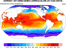 GHRSST: Group for High Resolution Sea Surface Temperature
Years of record
- to
The Group for High-Resolution Sea Surface Temperature (SST; GHRSST) provides a new generation of global high-resolution (10km) SST products to the operational oceanographic, meteorological, climate and general scientific community. The products are provided at a variety of processing levels including "gap-free" global grids. Each SST grid point must have associated with…
Experts contributing reviews
- N/A
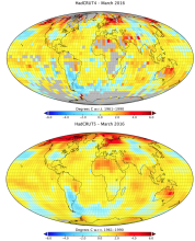 Global land-ocean surface temperature data: HadCRUT5
Years of record
- to
HadCRUT5 is one of the main datasets used to monitor global and regional surface temperature variability and trends. It is a global surface temperature product that combines land surface air temperatures from CRUTEM5 with SSTs from HadSST4. HadCRUT5 is a departure from its predecessors (HadCRUT4, HadCRUT3, etc.) in that two different versions are offered. Both versions…
Main variables and Earth System components
Atmosphere Air Temperature at 2m Ocean SST - sea surface temperature-
Formats
- netCDF
-
Timestep
- Monthly
-
Domain
- Global
-
Collections
- Diagnostic Data Sets
Experts contributing reviews
- Hausfather, Zeke
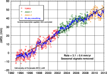 Global Mean Sea Level from TOPEX & Jason Altimetry
Years of record
- to
The global mean sea level timeseries is an excellent, integrative indicator of long-term global temperature trends, providing a record that is observed and processed independent of common metrics like global surface air temperature. The major contributions to the observed sea level trend of 3.3 mm/year include the ocean's thermal expansion, meltwater from mountain…
Experts contributing reviews
- Nerem, R.S.
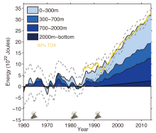
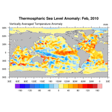 Global Ocean Heat and Thermospheric Sea Level Change
Years of record
- to
Using updated data from the World Ocean Database (Boyer et al, 2009) and improved ARGO profiling data, new estimates of ocean heat content and thermospheric sea level change (0-2000m) for the period 1955-2010 are derived.
Experts contributing reviews
- N/A
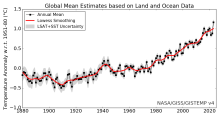 Global surface temperature data: GISTEMP: NASA Goddard Institute for Space Studies (GISS) Surface Temperature Analysis
Years of record
- to
NASA Goddard's Global Surface Temperature Analysis (GISTEMP) combines land surface air temperatures from GHCN-M version 4 with SSTs of the ERSSTv5 analysis into a comprehensive, global surface temperature data set spanning 1880 to the present at monthly resolution, on a 2x2 degree latitude-longitude grid. As such, it is one of the main data sets used to monitor global…
Main variables and Earth System components
Atmosphere Air Temperature Ocean SST - sea surface temperature-
Timestep
- Monthly
-
Domain
- Global
Experts contributing reviews
- Lenssen, Nathan
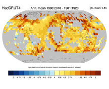 Global surface temperature data: HadCRUT4 and CRUTEM4
Years of record
- to
Extending back to 1850 and frequently updated, HadCRUT4 is the longest data set of its type. HadCRUT4 is a combination of the global land surface temperature data set, CRUTEM4 and the global SST data set, HadSST3. HadCRUT4 is different from the most closely comparable products (e.g. NASA GISTEMP and NOAA MLOST) in that no interpolation is performed. As such, there are…
Main variables and Earth System components
Atmosphere Air Temperature Ocean SST - sea surface temperature-
Timestep
- Climatology, Monthly
-
Domain
- Global
Experts contributing reviews
- N/A
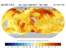 Global surface temperature data: MLOST: NOAA Merged Land-Ocean Surface Temperature Analysis
Years of record
- to
NOAA's Merged Land-Ocean Surface Temperature Analysis (MLOST) combines land surface air temperatures primarily from the Global Historical Climatology Network, Monthly (GHCN-M) version 3 with SSTs of the ERSSTv3b analysis into a comprehensive global surface temperature data set spanning 1880 to the present at monthly resolution, on a 5x5 degree latitude-longitude grid.…
Main variables and Earth System components
Atmosphere Air Temperature Ocean SST - sea surface temperature-
Timestep
- Monthly
-
Domain
- Global
Experts contributing reviews
- N/A
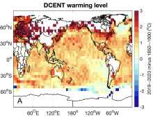 Global surface temperature data: The Dynamically Consistent ENsemble of Temperature (DCENT)
Years of record
- to
The Dynamically Consistent ENsemble of Temperature (DCENT) provides monthly, global, gridded, surface temperature anomalies since 1850. This product provides combined land surface air temperature (LSAT) and sea surface temperature (SST) anomalies at monthly 5° x 5° resolution. An important feature of DCENT is that both land and ocean measurements are used when bias-…
Main variables and Earth System components
Atmosphere Air Temperature at 2m Ocean SST - sea surface temperatureExperts contributing reviews
- Chan, Duo
 Global surface temperature: Maximum Likelihood Estimates of Temperatures using HadCRUT5 (Version 1.2)
Years of record
- to
The Maximum Likelihood Estimates of Temperatures using HadCRUT5 Version 1.2 (HadCRU_MLE_v1.2) dataset provides global complete surface temperature estimates since 1850, with monthly 5°x5° resolution. It uses more sophisticated statistical models to fill data gaps in the non-infilled version of HadCRUT5. The statistical models used in HadCRU_MLE_v1.2 better…
Main variables and Earth System components
Atmosphere Air Temperature at 2m Ocean SST - sea surface temperatureExperts contributing reviews
- Chan, Duo
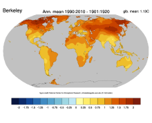 Global surface temperatures: BEST: Berkeley Earth Surface Temperatures
Years of record
- to
The Berkeley Earth Surface Temperatures (BEST) are a set of data products, originally a gridded reconstruction of land surface air temperature records spanning 1701-present, and now including an 1850-present merged land-ocean data set that combines the land analysis with an interpolated version of HadSST3. The land station data are available in an archive, and…
Main variables and Earth System components
Atmosphere Air Temperature Maximum Air Temperature Minimum Air Temperature Ocean SST - sea surface temperatureExperts contributing reviews
- Cowtan, Kevin
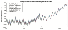
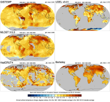 Global Temperature Data Sets: Overview & Comparison Table
Years of record
- to
Global surface temperature data sets are an essential resource for monitoring and understanding climate variability and long-term trends. The most commonly used data sets combine historical observations of near surface air temperatures at land stations with global data sets of sea surface temperatures (SST) obtained from a changing mix of ship-based and buoy…
Main variables and Earth System components
Atmosphere Air Temperature Air Temperature at 2m Ocean SST - sea surface temperature-
Timestep
- Climatology, Monthly
-
Domain
- Global
-
Collections
- Overview / Comparison page
Experts contributing reviews
- N/A
 GLODAP: GLobal Ocean Data Analysis Project for Carbon
Years of record
- N/A
The GLobal Ocean Data Analysis Project (GLODAP) is a cooperative effort to coordinate global synthesis projects funded through the National Oceanic and Atmospheric Administration (NOAA), the U.S. Department of Energy (DOE), and the National Science Foundation (NSF) as part of the Joint Global Ocean Flux Study - Synthesis and Modeling Project (JGOFS-SMP). Cruises…
-
Timestep
- Climatology
-
Domain
- Global
-
Collections
- Carbon cycle
Experts contributing reviews
- N/A
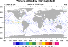 GODAS: NCEP Global Ocean Data Assimilation System
Years of record
- to
GODAS is a real-time ocean analysis and a reanalysis. It is used for monitoring, retrospective analysis as well as for providing oceanic initial conditions for the CFS. Both temperature and synthetic salinity profiles are assimilated in a 3DVAR scheme. Beginning with March 2007, altimetry sea level is assimilated.
Main variables and Earth System components
Ocean 3D Velocity SST - sea surface temperature Salinity heat flux isothermal layer depth mixed layer depth potential temperature salt flux sea surface height-
Timestep
- Monthly, Pentad
-
Domain
- Global
-
Collections
- Climate Analysis Section (CAS) Data Catalog
Experts contributing reviews
- N/A
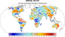 GRACE: Gravity Recovery and Climate Experiment: Surface mass, total water storage, and derived variables
Years of record
- to
The Gravity Recovery and Climate Experiment (GRACE) refers to a pair of NASA satellites that has flown in low-Earth orbit since 2002. The satellites use a precise microwave ranging system to measure the distance between themselves due to gravitational acceleration. Onboard GPS instruments determine the exact position of the satellites over the Earth. GRACE measures…
Main variables and Earth System components
Cryosphere Glaciers Ice Sheet Mass Land Groundwater surface water Water Storage Ocean Bottom pressure-
Timestep
- Daily, Monthly
-
Domain
- Global
-
Collections
- Diagnostic Data Sets, NCAR-DOE-CESM, landdiagnostics, landicediagnostics
Experts contributing reviews
- Swenson, Sean
 HadDTR: Hadley Centre sea-surface temperature diurnal temperature range climatology
Years of record
- N/A
The Hadley Centre sea-surface temperature diurnal temperature range climatology is a 5x5 degree gridded climatology of the diurnal range of sea surface temperature as measured by drifting buoys.
Experts contributing reviews
- N/A
 HadIOD: Met Office-Hadley Centre Integrated Ocean Database
Years of record
- to
HadIOD (Met Office Hadley Centre Integrated Ocean Database) is a global database of in situ ocean temperature and salinity observations, spanning 1850-present on a daily timestep. It is somewhat unique among temperature and salinity datasets in that it combines observations from both surface and sub-surface observing platforms. As such, it is well suited to activities…
Main variables and Earth System components
Ocean Salinity SST - sea surface temperature Sub Surface TemperatureExperts contributing reviews
- Atkinson, Chris
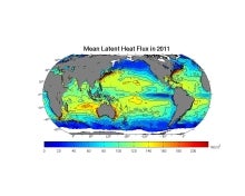
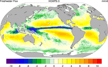 HOAPS: Hamburg Ocean Atmosphere Parameters and Fluxes from Satellite Data
Years of record
- to
The Hamburg Ocean Atmosphere Parameters and Fluxes from Satellite Data (HOAPS) set is a satellite-based climatology of precipitation, evaporation and freshwater budget (evaporation minus precipitation) as well as related turbulent heat fluxes and atmospheric state variables over the global ice free oceans. All variables are derived from SSM/I passive microwave…
Main variables and Earth System components
Atmosphere Evaporation Evaporation-Precipitation Precipitation Radiation Specific Humidity Wind Latent & sensible heat flux Precipitable water Ocean SST - sea surface temperature-
Formats
- netCDF
-
Timestep
- Climatology, Sub-daily, Monthly, Pentad
-
Domain
- Global
-
Collections
- Boundary Conditions
Experts contributing reviews
- N/A
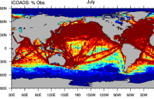 ICOADS Surface Marine Weather Observations
Years of record
- N/A
ICOADS (International Comprehensive Ocean-Atmosphere Data Set) is the most comprehensive archive of global marine surface climate observations available. Variables include SST, SLP, air temperature, wind speed, cloud amount, and others. There is no processing beyond initial quality control. ICOADS data are packaged in several different formats with different time…
Main variables and Earth System components
Atmosphere Air Temperature Budget Cloud Properties Latent & sensible heat flux Sea Level Pressure Specific Humidity Wind Ocean SST - sea surface temperatureExperts contributing reviews
- Deser, Clara
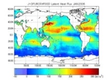 Japanese Ocean Flux Data sets with Use of Remote Sensing Observations (J-OFURO2)
Years of record
- to
These ocean surface flux data sets are derived primarily using data from multiple satellites. The COARE 3.0 bulk algorithm [Fairall et al. (2003)] is used in J-OFURO2 for the estimation of sensible and latent heat fluxes.
Main variables and Earth System components
Atmosphere Specific Humidity Wind Stress Latent & sensible heat flux Ocean Surface FluxExperts contributing reviews
- N/A
 Kaplan Sea Surface Temperature Anomalies
Years of record
- to
The most up-to-date version is known as Kaplan Extended SST v2, which combines statistically infilled grids of UK Met Office SSTs for 1856-1981 with a statistically reduced and coarser resolution version of Smith and Reynolds Optimally Interpolated (OI) SSTs for 1981 to present. Those desiring only recent data should use another product.
Experts contributing reviews
- Kaplan, Alexy
 Merged Hadley-NOAA/OI Sea Surface Temperature & Sea-Ice Concentration (Hurrell et al, 2008)
Years of record
- to
The merged Hadley-OI sea surface temperature (SST) and sea ice concentration (SIC) data sets were specifically developed as surface forcing data sets for AMIP style uncoupled simulations of the Community Atmosphere Model (CAM). The Hadley Centre's SST/SIC version 1.1 (HADISST1), which is derived gridded, bias-adjusted in situ observations, were merged with the NOAA-…
Main variables and Earth System components
Cryosphere Sea Ice Concentration Ocean SST - sea surface temperature-
Formats
- netCDF
-
Timestep
- Monthly
Experts contributing reviews
- N/A
 Meridional Modes and their indices
Years of record
- N/A
In each of the world’s tropical ocean basins, year-to-year climate variability is primarily governed by fluctuations in the zonal sea surface temperature (SST) gradient and zonal surface winds. These variations consist of recognizable climate modes, such as the El Niño-Southern Oscillation (ENSO) in the tropical Pacific and Atlantic Niño in the tropical Atlantic. While…
-
Formats
- N/A
-
Timestep
- N/A
-
Domain
- Atlantic Ocean, Pacific Ocean
-
Collections
- N/A
Experts contributing reviews
- Amaya, Dillon
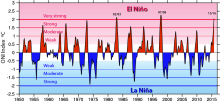
 Nino SST Indices (Nino 1+2, 3, 3.4, 4; ONI and TNI)
Years of record
- to
There are several indices used to monitor the tropical Pacific, all of which are based on sea surface temperature (SST) anomalies averaged across a given region. Usually the anomalies are computed relative to a base period of 30 years. The Niño 3.4 index and the Oceanic Niño Index (ONI) are the most commonly used indices to define El Niño and La…
-
Formats
- ascii
-
Timestep
- Monthly
-
Domain
- Pacific Ocean, Tropics
-
Collections
- Climate Analysis Section (CAS) Data Catalog
Experts contributing reviews
- Trenberth, Kevin
 OAFlux: Objectively Analyzed air-sea Fluxes for the global oceans.
Years of record
- to
"The OAFlux project aims to provide consistent, multi-decade, global analysis of air-sea heat, freshwater (evaporation), and momentum fluxes for use in studies of global energy budget, water cycle, atmosphere and ocean circulation, and climate. The OAFlux project is so called because it applies objective analysis approach to take into account data errors in the…
Main variables and Earth System components
Atmosphere Latent & sensible heat flux Radiation Wind Ocean SST - sea surface temperature Surface Flux wind stress curlExperts contributing reviews
- N/A
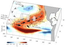
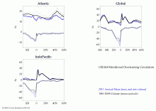
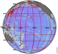
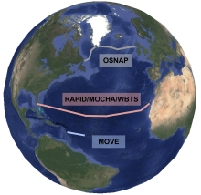 Observations of the Atlantic Meridional Overturning Circulation (AMOC)
Years of record
- N/A
The Atlantic Meridional Overturning Circulation (AMOC) is comprised of a series of northward surface currents and southward currents at depth in the Atlantic Basin. It is a key part of the global ocean circulation and is responsible for substantial oceanic heat transport, deep water formation, and controlling regional climate. It is possible that climate change has and…
Main variables and Earth System components
Ocean-
Formats
- N/A
-
Timestep
- N/A
-
Domain
- N/A
-
Collections
- N/A
Experts contributing reviews
- Lankhorst, Matthias
 Ocean heat content for 10-1500m depth based on Argo
Years of record
- to
A regularly updated monthly timeseries of ocean heat content, based on Argo profiles, is integrated over 10-1500m depth and the latitudes 60°S-60°N. Coverage begins in 2005. It is estimated based on the method described in von Schuckmann and Le Traon (2011) and discussed in the context of other methods below.
Experts contributing reviews
- von Schuckmann, Karina
 Ocean temperature analysis and heat content estimate from Institute of Atmospheric Physics
Years of record
- to
The Institute of Atmospheric Physics (IAP) ocean temperature analysis features global coverage of the oceans, at 1° x1° horizontal resolution on 41 vertical levels from 1-2000m, and monthly resolution from 1940 to present. As such, it is aimed at studies of climate variability and change, from large regional to global scales, on timescales of months to decades.…
Main variables and Earth System components
Ocean Ocean Heat Content Sea Level Sub Surface TemperatureExperts contributing reviews
- Cheng, Lijing
 ORAS4: ECMWF Ocean Reanalysis and derived ocean heat content
Years of record
- to
ECMWF's current ocean reanalysis uses a sophisticated data assimilation methodology which includes a model bias correction. The ocean model used is forced by atmospheric daily surface fluxes, relaxed to SST and bias corrected. The Balmaseda et al (QJRMS 2013) reference provides excellent peer reviewed documentation and evaluation.
Main variables and Earth System components
Ocean Ocean Heat Content Salinity Sea Level potential temperature u, v current components-
Timestep
- Monthly
-
Domain
- Global
-
Collections
- Climate Analysis Section (CAS) Data Catalog
Experts contributing reviews
- N/A
 Overview: Climate Indices
Years of record
- N/A
A climate index is a simple diagnostic quantity that is used to characterize an aspect of a geophysical system such as a circulation pattern. A variety of methods have been used to derive assorted indices. Classically, selected station, grid point or regional average data have been used (eg., Southern Oscillation Index, Nino 3.4). Other indices are based upon empirical…
-
Formats
- N/A
-
Timestep
- N/A
-
Domain
- N/A
-
Collections
- Overview / Comparison page
Experts contributing reviews
- N/A
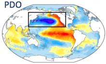 Pacific Decadal Oscillation (PDO): Definition and Indices
Years of record
- to
The Pacific Decadal Oscillation (PDO) is defined by the leading pattern (EOF) of sea surface temperature (SST) anomalies in the North Pacific basin (typically, polewards of 20°N). The SST anomalies are obtained by removing both the climatological annual cycle and the global-mean SST anomaly from the data at each gridpoint. Positive values of the PDO index…
-
Formats
- ascii
-
Timestep
- Monthly
-
Domain
- Pacific Ocean
-
Collections
- N/A
Experts contributing reviews
- Deser, Clara, Trenberth, Kevin
 PACIFICA: PACIFic ocean Interior CArbon
Years of record
- to
PACIFICA (PACIFic ocean Interior CArbon) was an international collaborative project for the data synthesis of ocean interior carbon and its related parameters in the Pacific Ocean. The North Pacific Marine Science Organization (PICES), Section of Carbon and Climate (S-CC) supported the project. We have merged hydrographic/hydrochemical datasets from a total of 213…
-
Formats
- ascii
-
Timestep
- Sub-daily
-
Domain
- Pacific Ocean
-
Collections
- Carbon cycle
Experts contributing reviews
- N/A
 Pan-Arctic Ice Ocean Modeling and Assimilation System (PIOMAS)
Years of record
- to
The Pan-Arctic Ice-Ocean Modeling and Assimilation System (PIOMAS) is a reanalysis data set that uses a coupled ice and ocean model to provide daily and monthly estimates of Arctic sea-ice thickness. The data is publicly available from January 1979 to in near-real time. The model is developed and maintained by the Polar Science Center (PSC) in the Applied Physics…
Experts contributing reviews
- Labe, Zachary
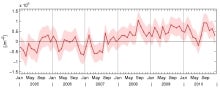
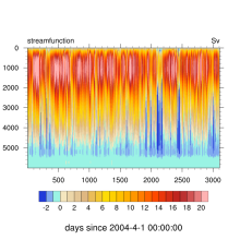 RAPID: monitoring the Atlantic Meridional Overturning Circulation at 26.5°N
Years of record
- to
"The Rapid Climate Change programme (RAPID) explores what causes rapid switches in climate, with a main (but not exclusive) focus on the Atlantic Ocean's thermohaline circulation." "A principal objective of the RAPID programme is the development and maintenance of a pre-operational prototype system that will continuously observe the strength and structure of the MOC. An…
Main variables and Earth System components
Ocean Salinity Sub Surface Temperature heat flux streamfunction-
Timestep
- Sub-daily
-
Domain
- Atlantic Ocean
-
Collections
- Diagnostic Data Sets
Experts contributing reviews
- N/A
 Sea Ice Concentration Climate Data Record from OSI SAF
Years of record
- to
The Ocean and Sea Ice Satellite Applications Facility (OSI SAF) of EUMETSAT provides sea ice concentration products for the Arctic and Antarctic based on satellite passive microwave data. The concentration value is expressed as the fractional percentage of the ice cover in a given grid cell. Since 2023, OSI-450-a and OSI-430-a constitute the third fully…
-
Formats
- netCDF
-
Timestep
- Daily
-
Collections
- N/A
Experts contributing reviews
- Aaboe, Signe, Lavergne, Thomas
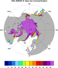 Sea Ice Concentration data from AMSR-E, AMSR2 & SSMIS, U Bremen and U Hamburg ASI algorithm
Years of record
- to
The sea ice data derived from AMSR-E using the ARTIST sea ice (ASI) algorithm offer a factor of 4 finer spatial resolution than most sea ice data sets from passive microwave satellite instruments. ASI is based on the difference of vertically and horizontally polarized brightness temperatures at 89 GHz; this difference is independent of temperature but depends on…
-
Timestep
- Daily
-
Collections
- N/A
Experts contributing reviews
- N/A
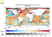
 Sea Ice Concentration data from HadISST
Years of record
- to
Spanning 1871-present at monthly timesteps, HadISST provides the longest gridded sea ice data available for both the Arctic and Antarctic. It is a 1° x 1° spatially infilled data set that is It is intended as a consistent analyses for input into SST analyses or as boundary conditions for models. Version 1.1 is the currently available data set and is the one described…
-
Timestep
- Monthly
-
Collections
- Boundary Conditions
Experts contributing reviews
- N/A
 Sea Ice Concentration data from NASA Goddard and NSIDC based on Bootstrap algorithm
Years of record
- to
Bootstrap sea ice refers to a well-known algorithm used to estimate sea ice concentration from passive microwave brightness temperatures. It can be applied to data from many satellite instruments, such as SMMR, SSMI, and AMSR-E. This page discusses the algorithm itself and the long-term data set ("NSIDC 0079, version 2") produced by J. Comiso and distributed by NSIDC.…
-
Timestep
- Daily, Monthly
-
Collections
- N/A
Experts contributing reviews
- N/A
 Sea Ice Concentration data from NASA Goddard and NSIDC based on NASA Team algorithm
Years of record
- to
NASA Team sea ice refers to a well-known algorithm used to estimate sea ice concentration from passive microwave brightness temperatures. This page discusses the algorithm itself and the long-term data set ("NSIDC 0051") produced by scientists at NASA Goddard and distributed by NSIDC. The NASA Team data are very widely used and are a key input into other data sets…
-
Timestep
- Daily, Monthly
-
Collections
- Diagnostic Data Sets, NCAR-DOE-CESM, seaicediagnostics
Experts contributing reviews
- N/A
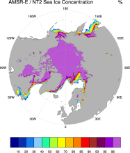 Sea Ice Concentration data from NASA Goddard and NSIDC using AMSR-E and NASA TEAM2 (NT2) algorithm
Years of record
- to
The AMSR-E/NASA Team 2 (NT2) data set of Arctic and Antarctic sea ice concentration is available at daily timesteps and 12.5 km (optionally 25km) spatial resolution for 2002-2011. NT2, an extension of the original NASA Team algorithm, uses AMSR-E 89GHz channels to help resolve ambiguity between low ice concentrations and areas with strong surface effects (due to snow…
Experts contributing reviews
- N/A
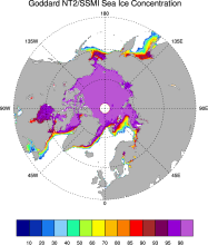 Sea ice concentration data from NASA Goddard based on SSMI and NASA Team (NT2) algorithm
Years of record
- to
The NASA Team 2 (NT2) / SSMI data set of Arctic and Antarctic sea ice concentration is available at daily timesteps and 25km spatial resolution for 1992-2008. NT2, an extension of the original NASA Team algorithm, uses SSMI 85GHz channels to help resolve ambiguity between low ice concentrations and areas with strong surface effects (due to snow layering and glazing).…
Experts contributing reviews
- N/A
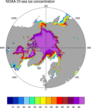 Sea Ice Concentration data from NOAA OI
Years of record
- to
The NOAA Optimal Interpolation (OI) v2 sea ice data set contains gridded, weekly or monthly resolution sea ice concentration estimates for both the Northern and Southern Hemispheres. It is intended as a consistent analyses for input into SST analyses (and is the basis for calculating SSTs in sea ice zones for the OI SST data) or as boundary conditions for atmospheric…
-
Formats
- netCDF
-
Timestep
- Monthly, Weekly
-
Collections
- Boundary Conditions
Experts contributing reviews
- N/A
 Sea Ice Concentration data: Overview, Comparison table and graphs
Years of record
- N/A
Sea ice concentration is both an indicator and driver of changes high-latitude climate with strong societal and ecological importance. It is a key boundary condition for atmospheric models (including those used in atmospheric reanalyses) and a benchmark for coupled climate models. As such, numerous methods have been developed to estimate sea ice concentration. The most…
-
Formats
- N/A
-
Timestep
- N/A
-
Collections
- Overview / Comparison page
Experts contributing reviews
- N/A
 Sea Ice Concentration: NOAA/NSIDC Climate Data Record
Years of record
- to
The NOAA/NSIDC Climate Data Record (CDR) of sea ice concentration is available at 25 x 25 km spatial resolution in daily or monthly timesteps for 1987-2014. It provides a consistent interpretation of sea ice for the satellite record, with the intent of being suitable for studies of climate variability and change. The CDR is produced by an automated and independent…
-
Formats
- netCDF
-
Timestep
- Daily, Monthly
-
Collections
- Climate Data Record
Experts contributing reviews
- Meier, Walter
 SeaWIFS: ocean bio-optical and carbon properties
Years of record
- to
The purpose of the Sea-viewing Wide Field-of-view Sensor (SeaWiFS) Project is to provide quantitative data on global ocean bio-optical properties and to assess the oceans' role in the global carbon cycle. SeaWiFS data are being used to help clarify the magnitude and variability of chlorophyll and primary production by marine phytoplankton, and to determine the…
-
Formats
- HDF
-
Timestep
- Climatology, Daily, Monthly, Seasonal, Annual
-
Domain
- Global
-
Collections
- Carbon cycle
Experts contributing reviews
- N/A
 SODA: Simple Ocean Data Assimilation
Years of record
- to
The Simple Ocean Data Assimilation, or SODA, analysis is an ocean reanalysis data set consisting of gridded variables for the global ocean, as well as several derived fields. The goal is to provide an improved estimate of ocean state from those based solely on observations or numerical simulations.
Main variables and Earth System components
Wind Stress Ocean 3D Velocity potential temperature Salinity sea surface height SST - sea surface temperature u, v current componentsExperts contributing reviews
- N/A
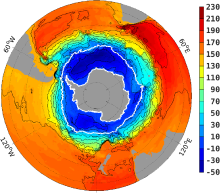 Southern Ocean State Estimate (SOSE)
Years of record
- to
The Southern Ocean State Estimate (SOSE) is a model-generated best fit to Southern Ocean observations. As such, it provides a quantitatively useful climatology of the mean-state of the Southern Ocean. Technically, SOSE is a solution to the MITgcm. SOSE is a gridded dataset at 1/6 ° horizontal resolution, available at timesteps from daily to annually.…
Main variables and Earth System components
Ocean 3D Velocity Bottom pressure SST - sea surface temperature Salinity Sub Surface Temperature mixed layer depth sea surface height u, v current components Wind Stress-
Formats
- binary
-
Timestep
- Daily, Monthly, Weekly, Annual
-
Collections
- N/A
Experts contributing reviews
- Mazloff, Matthew
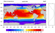
 SST (AMSR-E): Sea Surface Temperature from Remote Sensing Systems
Years of record
- to
High resolution (0.25°) SSTs were derived from the AMSR-E, a passive microwave radiometer flying on NASA's AQUA satellite. Remote Sensing Systems distributes the data in high spatial and temporal (daily, weekly, monthly) resolutions for both daytime and nighttime averages. Monthly versions are available on a 1°x1° grid from JPL PO-DAAC as well as the CMIP5 obs4MIPS…
Experts contributing reviews
- N/A
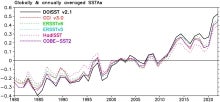
- SST Data Sets: Overview & Comparison Table
Years of record
- to
This overview focuses on SST datasets designed for climate applications. The focus is on datasets with coverage back to around 1850 at monthly resolution but select datasets over the satellite era that have been specifically developed as climate monitoring resources are also included. Note that information on high-resolution (10km daily or higher) operational satellite-…
-
Formats
- N/A
-
Timestep
- Climatology, Daily, Monthly, Weekly
-
Domain
- Global
-
Collections
- Overview / Comparison page
Experts contributing reviews
- Chan, Duo, Kent, Elizabeth
 SST data: COBE: Centennial in situ Observation-Based Estimates
Years of record
- to
The COBE data set is a spatially complete, interpolated 1°x1° SST product for 1891 to present. It combines SSTs from ICOADS release 2.0, the Japanese Kobe collection, and reports from ships and buoys. Data are gridded using optimal interpolation. As in HadISST, data up to 1941 were bias-adjusted using the "bucket correction." Prior to the interpolation analyses, data…
Experts contributing reviews
- N/A
 SST Data: COBEv3: Centennial in situ Observation-Based Estimates Version 3
Years of record
- to
The Centennial in situ Observation-Based Estimates of Sea Surface Temperature version 3 (COBE-SST3) is a SST analysis produced by the Japanese Meteorological Agency (JMA). The main COBE-SST3 reconstruction provides spatially complete estimates of SST over the global oceans, seas, and large lakes at daily temporal resolution on a regular 0.25° grid. The product currently…
Experts contributing reviews
- Ishii, Masayoshi
 SST data: HadiSST v1.1
Years of record
- to
The Hadley Centre Global Sea Ice and Sea Surface Temperature (HadISST) is a combination of monthly globally complete fields of SST and sea ice concentration for 1871-present. This page focuses on the SST data; see the separate page for discussion of HadISST sea ice. HadISST uses reduced space optimal interpolation applied to SSTs from the Marine Data Bank (mainly ship…
-
Timestep
- Monthly
-
Domain
- Global
Experts contributing reviews
- N/A
 SST data: HadSST3
Years of record
- to
Note: HadSST3 has been superseded by HadSST4. HadSST3 provides monthly SST anomalies on a 5°x5° grid for 1850-present. The anomalies are derived from a 30-year climatology spanning 1961-90.Coverage is global but there is no interpolation; Thus, missing data occur in the final product. The primary input data are from ICOADS release 2.5. Bias adjustments to the ICOADS…
-
Timestep
- Monthly
-
Domain
- Global
Experts contributing reviews
- Kennedy, John
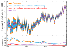
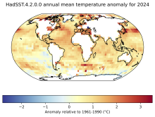 SST data: HadSST4
Years of record
- to
HadSST4 provides monthly SST anomalies on a 5°x5° grid for 1850-present. The anomalies are derived from a 30-year climatology spanning 1961-90. Coverage is global but there is no interpolation; Thus, missing data occur in the final product. This means that uncertainties due to limited spatial coverage and systematic errors are relatively easy to identify compared with…
-
Formats
- netCDF
-
Timestep
- Monthly
-
Domain
- Global
-
Collections
- Diagnostic Data Sets
Experts contributing reviews
- Kennedy, John, Sandford, Caroline
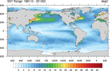
 SST data: NOAA daily Optimum Interpolation Sea Surface Temperature version 2.1, OISSTv2.1
Years of record
- to
NOAA’s daily Optimum Interpolation Sea Surface Temperature (dOISST, also known as Reynolds’ SST or OISST) is a global SST analysis product. An SST analysis is a spatially gridded product created by interpolating and extrapolating data, resulting in a smoothed spatially-complete field. dOISST provides global fields that are based on a combination of ocean temperature…
Experts contributing reviews
- Huang, Boyin, Yin, Xungang
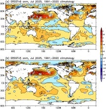
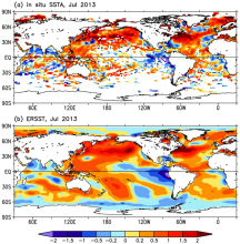
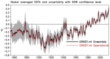
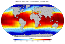 SST Data: NOAA Extended Reconstruction SSTs Version 5 (ERSSTv5)
Years of record
- to
Note: ERSST is currently on version 6. See the ERSSTv6 page here. The NOAA Extended Reconstruction Sea Surface Temperature (ERSST) provides global, spatially complete SST data at a monthly timestep for 1854-present. Version5 is based upon statistical interpolation of the ICOADS release 3.0 data. Argo float data are used in the recent years (since ~2000). The data…
-
Timestep
- Climatology, Monthly
-
Domain
- Global
-
Collections
- Diagnostic Data Sets
Experts contributing reviews
- Hausfather, Zeke
 SST Data: NOAA Extended Reconstruction SSTs Version 6 (ERSSTv6)
Years of record
- to
The NOAA Extended Reconstruction Sea Surface Temperature version 6 (ERSSTv6) is a global, spatially complete SST data at monthly 2°×2° resolutions based on in situ observations for 1850-present. Version 6 is based upon statistical interpolation of the ICOADS release 3.0.2 SST data. Argo float data are also used in the recent years (since ~2000). The data are distributed…
Experts contributing reviews
- Huang, Boyin, Yin, Xungang
 SST data: NOAA Extended Reconstruction SSTs, version 3 (ERSSTv3 & 3b)
Years of record
- to
Note: ERSST is currently on version 6. See the ERSSTv6 page here. The NOAA Extended Reconstruction Sea Surface Temperature (ERSST) provides global, spatially complete SST data at a monthly timestep for 1854-present. Version3 is based upon statistical interpolation of the ICOADS release 2.4 data. Version 3 includes satellite AVHRR SST data for 1985 onwards. Version…
-
Timestep
- Monthly
-
Domain
- Global
Experts contributing reviews
- Huang, Boyin, Livermore, Jay, Smith, Tom
 SST data: NOAA Extended Reconstruction SSTs, Version 4
Years of record
- to
Note: ERSST is currently on version 6. See the ERSSTv6 page here. The NOAA Extended Reconstruction Sea Surface Temperature (ERSST) provides global, spatially complete SST data at a monthly timestep for 1854-present. Compared to the previous version, Version 4 uses the more extensive ICOADS Release 2.5 data and revised quality control, bias adjustment, and…
Experts contributing reviews
- Huang, Boyin
 SST data: NOAA High-resolution (0.25x0.25) Blended Analysis of Daily SST and Ice, OISSTv2
Years of record
- to
"NOAA’s Optimum Interpolation Sea Surface temperature (OISST, also known as Reynolds’ SST) is a series of global analysis products, including the weekly OISST on a 1° grid to the more recent daily on a ¼° grid. An SST analysis is a spatially gridded product created by interpolating and extrapolating data, resulting in a smoothed complete field. OISST provides global…
Main variables and Earth System components
Cryosphere Sea Ice Concentration Ocean SST - sea surface temperatureExperts contributing reviews
- Banzon, Viva, Reynolds, Richard
 SST data: NOAA Optimal Interpolation (OI) SST Analysis, version 2 (OISSTv2) 1x1
Years of record
- to
The NOAA Optimal Interpolation SST analysis provides global, spatially complete SSTs on a weekly and monthly basis for 1982-present.
Experts contributing reviews
- Banzon, Viva, Reynolds, Richard
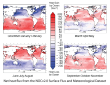 Surface Flux and Meteorological Dataset: National Oceanography Centre (NOC) V2.0
Years of record
- to
The National Oceanography Centre (NOC) Version 2.0 Surface Flux and Meteorological Dataset is a monthly mean gridded dataset of marine surface measurements and derived fluxes constructed using optimal interpolation. Input for the period 1973 to 2006 are ICOADS Release 2.4 ship data and the update from 2007 to 2014 uses ICOADS Release 2.5. The dataset is presented…
-
Formats
- netCDF
-
Timestep
- Monthly
-
Domain
- Global
-
Collections
- Climate Data Record
Experts contributing reviews
- Kent, Elizabeth
 Tide gauge sea level data
Years of record
- to
The global sea level record from tide gauges is an important indicator of the evolution and impact of global change. Tide gauge data also capture a variety of local and regional phenomena related to decadal climate variability, tides, storm surges, tsunamis, swells, and other coastal processes. Tide gauge data are used to validate ocean models and to detect…
-
Formats
- N/A
-
Timestep
- Sub-daily, Daily, Monthly, Annual
-
Domain
- Global
-
Collections
- N/A
Experts contributing reviews
- Hamlington, Benjamin, Thompson, Phil
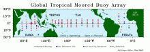 Tropical Moored Buoy System: TAO, TRITON, PIRATA, RAMA (TOGA)
Years of record
- to
The Tropical Ocean Global Atmosphere program (TOGA) is a component of the World Climate Research Programme (WCRP) aimed specifically at the prediction of climate phenomena on time scales of months to years. In order to achieve the TOGA goals, a strategy of large-scale, long-term monitoring of the upper ocean and the atmosphere has been developed. In particular, several…
Main variables and Earth System components
Atmosphere Air Temperature Precipitation Radiation Relative Humidity Sea Level Pressure Wind Ocean Absolute Dynamic Topography (ADT) Ocean Heat Content SST - sea surface temperature Salinity Sub Surface Salinity Sub Surface Temperature u, v current componentsExperts contributing reviews
- N/A
 Walsh and Chapman Northern Hemisphere Sea Ice
Years of record
- to
The Walsh and Chapman Sea Ice Data Set provides a long record of Arctic sea ice concentrations on a monthly basis for 1870-2011. Historical observations were gridded and combined with satellite-derived sea ice concentrations for the recent decades. Mostly climatologies before the 1950s. The Walsh and Chapman sea ice data set is the main input data set into the HadiSST…
-
Formats
- ascii
-
Timestep
- Monthly
-
Domain
- NH - Northern Hemisphere, Arctic
-
Collections
- N/A
Experts contributing reviews
- Chapman, William
 World Ocean Atlas (WOA09)
Years of record
- N/A
World Ocean Atlas 2009 (WOA09) is a set of objectively analyzed (1 degree grid) climatological fields of in situ temperature, salinity, dissolved oxygen, Apparent Oxygen Utilization (AOU), percent oxygen saturation, phosphate, silicate, and nitrate at standard depth levels for annual, seasonal, and monthly compositing periods for the World Ocean. It also includes…
Main variables and Earth System components
Ocean Dissolved Oxygen SST - sea surface temperature Salinity Sub Surface Salinity Sub Surface Temperature oxygen saturation phosphate silicate-
Timestep
- Climatology, Monthly, Seasonal, Annual
-
Domain
- Global
-
Collections
- Diagnostic Data Sets, NCAR-DOE-CESM, oceandiagnostics
Experts contributing reviews
- N/A
 World Ocean Atlas 2013 (WOA13)
Years of record
- to
The World Ocean Atlas (WOA) is a set of climatological mean, gridded fields of oceanographic variables based on in-situ measurements from a wide variety of sources. Global, decadal averages of temperature, salinity, oxygen and nutrients are provided at monthly, seasonal and annual averaging periods on 102 standard depth levels from 0 to 5500m, and at 0.25° (…
Main variables and Earth System components
Ocean Dissolved Oxygen phosphate potential temperature silicate SST - sea surface temperature Sub Surface Salinity Sub Surface Temperature Sub-surface data-
Timestep
- Climatology, Monthly, Seasonal
-
Domain
- Global
-
Collections
- Diagnostic Data Sets, NCAR-DOE-CESM, oceandiagnostics
Experts contributing reviews
- Mishonov, Alexey