WASWind: Wave and Anemometer-based Sea Surface Wind
"WASWind (Wave and Anemometer-based Sea Surface Wind) provides a bias-corrected marine surface wind dataset over the global oceans. Variables include scalar, zonal and meridional winds at 10-meter high, and zonal and meridional components of wind stress. WASWind has been constructed from wind observations in ICOADS (International Comprehensive Ocean-Atmosphere Data Set) and is available at monthly resolution on a 4° x 4° grid from 1950 to 2009. Ship-based measurements of marine surface wind are known to have a spurious upward trend due to increases in anemometer height. WASWind substantially reduces the upward trend in wind speed through height-correction for anemometer-measured winds, rejection of spurious Beaufort winds, and use of estimated winds from wind wave height. "
Key Strengths
Bias corrections for ship-based wind measurements
Long record allows investigation of climate variability and long-term trends
Key Limitations
Sparse data coverage especially in the Southern Ocean and sea ice regions
No estimate of uncertainty
Expert Developer Guidance
The following was contributed by Hiroki Takinaga (U Hawaii), April, 2012:
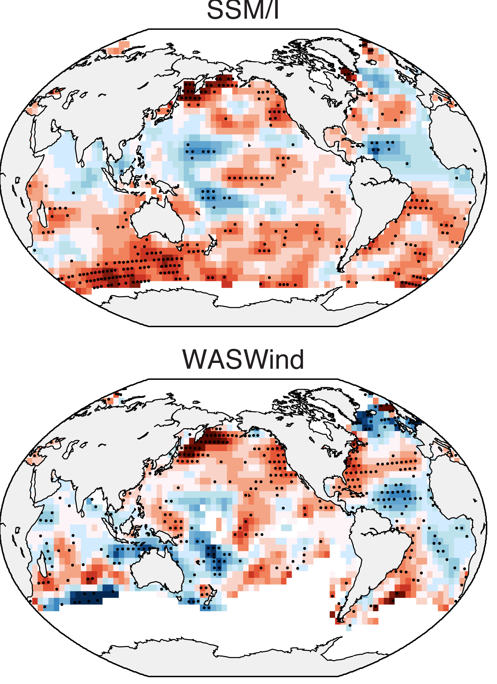
WASWind (Wave and Anemometer-based Sea Surface Wind) provides a bias-corrected marine surface wind dataset over the global oceans. Variables include scalar, zonal and meridional winds at 10-meter high, and zonal and meridional components of wind stress. WASWind has been constructed from wind observations in ICOADS (International Comprehensive Ocean-Atmosphere Data Set) and is available at monthly resolution on a 4° x 4° grid from 1950 to 2009. Ship-based measurements of marine surface wind are known to have a spurious upward trend due to increases in anemometer height. WASWind substantially reduces the upward trend in wind speed through height-correction for anemometer-measured winds, rejection of spurious Beaufort winds, and use of estimated winds from wind wave height. The reduced upward trend is smallest among the existing global datasets of in situ observations and comparable with those of reanalysis products. Despite the significant reduction of globally-averaged wind speed trend, WASWind features rich spatial structures in trend pattern, making it a valuable dataset for studies of variability and long-term trends on regional scales. Not only does the combination of ship winds and wind wave height successfully reproduce major modes of seasonal-to-decadal variability, but its trend patterns are also physically consistent with sea level pressure (SLP) measurements. WASWind is in close agreement with wind changes in satellite measurements by the Special Sensor Microwave Imager (SSM/I) for the recent two decades. The agreement in trend pattern with such independent observations illustrates the utility of WASWind for climate trend analysis.#
Cite this page
Acknowledgement of any material taken from or knowledge gained from this page is appreciated:
Tokinaga, Hiroki & National Center for Atmospheric Research Staff (Eds). Last modified "The Climate Data Guide: WASWind: Wave and Anemometer-based Sea Surface Wind.” Retrieved from https://climatedataguide.ucar.edu/climate-data/waswind-wave-and-anemometer-based-sea-surface-wind on 2026-06-06.
Citation of datasets is separate and should be done according to the data providers' instructions. If known to us, data citation instructions are given in the Data Access section, above.
Acknowledgement of the Climate Data Guide project is also appreciated:
Schneider, D. P., C. Deser, J. Fasullo, and K. E. Trenberth, 2013: Climate Data Guide Spurs Discovery and Understanding. Eos Trans. AGU, 94, 121–122, https://doi.org/10.1002/2013eo130001
Key Figures
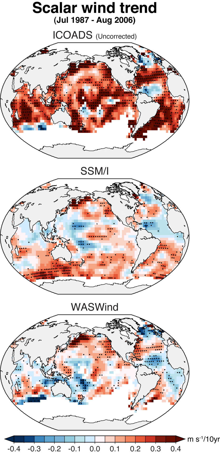
Comparison of scalar wind trend for Jul 1987 - August 2006 for (top) raw ICOADS, (middle) SSM/I, and (bottom) WASWind. (Contributed by H. Tokinaga)
Other Information
- Tokinaga, H., and S.-P. Xie, 2011: Wave- and Anemometer-based Sea Surface Wind (WASWind) for climate change analysis. J. Climate, 24, 267-285.
- Tokinaga, H., and S.-P. Xie, 2011: Weakening of the equatorial Atlantic cold tongue over the past six decades. Nature Geosci., 4, 222-226.
- Tokinaga, H., S.-P. Xie, A. Timmermann, S. McGregor, T. Ogata, H. Kubota, and Y. M. Okumura, 2012: Regional patterns of tropical Indo-Pacific climate change: Evidence of the Walker circulation weakening. J. Climate, 25, 1689-1710.