CMCC Global Ocean Reanalysis System (C-GLORS)

"The CMCC Global Ocean Physical Reanalysis System (C-GLORS) is used to simulate the state of the ocean in the last decades. It consists of a variational data assimilation system (OceanVar), capable of assimilating all in-situ observations along with altimetry data, and a forecast step performed by the ocean model NEMO coupled with the LIM2 sea-ice model."
Key Strengths
Key Limitations
Freely available upon registration
Expert Developer Guidance
The following was contributed by Dr. Andrea Storto (CMCC, Italy), October, 2014:
"Summary: The CMCC Global Ocean Physical Reanalysis System (C-GLORS) is used at CMCC to simulate the state of the ocean in the last decades. It consists of a variational data assimilation system (OceanVar), capable of assimilating all in-situ observations along with altimetry data, and a forecast step performed by the ocean model NEMO coupled with the LIM2 sea-ice model.
Key Strengths:
-Data dissemination is provided for a very large number of ocean parameters
-An extensive validation has been conducted and is freely available, confirming the good quality of the dataset
-The reanalysis is performed at high resolution (1/4 degree) and spans the last 30 years, covering the entire era of meteorological satellites
Key Limitations:
-Quality may be discontinuos and depend on observation coverage
-Uncertainty estimates are simply derived through verification skill scores
-Net surface heat flux seems underestimated at high latitudes
C-GLORS provides a 3D picture of the state of the ocean at 1/4 degree resolution for the meteorological satellite era (1982-2012).
It can be used for a wide range of applications, from climate monitoring to ocean dynamics studies, to models validation and comparisons, and downstream application (e.g. fisheries, biogeochemistry, etc.).
While climate signals are generally well reproduced, users should pay attention to the period where changes in observing system are present (mostly when altimetric missions start, October 1992, or when Argo data come in the system, 2001-2004)."##
Cite this page
Acknowledgement of any material taken from or knowledge gained from this page is appreciated:
Storto, Andrea & National Center for Atmospheric Research Staff (Eds). Last modified "The Climate Data Guide: CMCC Global Ocean Reanalysis System (C-GLORS).” Retrieved from https://climatedataguide.ucar.edu/climate-data/cmcc-global-ocean-reanalysis-system-c-glors on 2026-06-05.
Citation of datasets is separate and should be done according to the data providers' instructions. If known to us, data citation instructions are given in the Data Access section, above.
Acknowledgement of the Climate Data Guide project is also appreciated:
Schneider, D. P., C. Deser, J. Fasullo, and K. E. Trenberth, 2013: Climate Data Guide Spurs Discovery and Understanding. Eos Trans. AGU, 94, 121–122, https://doi.org/10.1002/2013eo130001
Key Figures
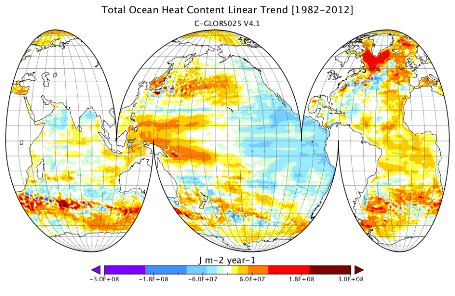
Ocean Heat Content Linear Trend (1982-2012) as simulated by the last version of C-GLORS at 0.25 degree resolution. (contributed by A. Storto)
Other Information
- Andrea Storto, Srdjan Dobricic, Simona Masina, and Pierluigi Di Pietro, 2011: Assimilating Along-Track Altimetric Observations through Local Hydrostatic Adjustment in a Global Ocean Variational Assimilation System. Mon. Wea. Rev., 139, 738–754.
- Andrea Storto, Simona Masina, and Srdjan Dobricic, 2014: Estimation and Impact of Nonuniform Horizontal Correlation Length Scales for Global Ocean Physical Analyses. J. Atmos. Oceanic Technol., 31, 2330–2349.