Surface Flux and Meteorological Dataset: National Oceanography Centre (NOC) V2.0

The National Oceanography Centre (NOC) Version 2.0 Surface Flux and Meteorological Dataset is a monthly mean gridded dataset of marine surface measurements and derived fluxes constructed using optimal interpolation. Input for the period 1973 to 2006 are ICOADS Release 2.4 ship data and the update from 2007 to 2014 uses ICOADS Release 2.5. The dataset is presented as a time series of monthly mean values on a 1 degree area grid. Included variables are: heat fluxes (sensible, latent, shortwave radiation, longwave radiation), air temperature, sea surface temperature, wind speed, specific humidity, pressure and cloud cover. The quality of the gridded data is quantified by estimates of random, bias and total uncertainty. The monthly means were derived from daily estimates of each variable and the standard deviation of these daily values is also available. Users are advised to take account of the uncertainty estimates provided, and to note that in very poorly sampled regions, such as the Southern Ocean, the uncertainty estimates themselves may be unreliable. Surface meteorological fields have been adjusted to account for varying measurement heights and for known biases. Surface fluxes have been calculated from daily fields of the surface meteorological parameters using bulk parameterizations.
Key Strengths
Key Limitations
Expert Developer Guidance
The following was contributed by Dr. Elizabeth Kent (National Oceanography Centre, UK), September, 2013:
The NOCv2.0 Surface Flux and Meteorological Dataset is an in situ only gridded dataset based on the International Comprehensive Ocean-Atmosphere Data Set (ICOADS). Fluxes are calculated using bulk flux formulae from daily fields of near-surface air and sea temperatures, humidity, wind speed, pressure and cloud cover.
1. Key strengths
The dataset is constructed from ICOADS observations that have been adjusted for observational bias and to a common reference height of 10 meters. Estimates of random, bias and total uncertainty are provided for every month and location on the 1-degree grid. The dataset is independent of reanalyses (although many reanalyses also use ICOADS as an input data source) and also independent of satellite measurements. The dataset is publicly available as monthly means, but daily fields can be provided on request.
2. Key limitations
Sampling density is variable as ICOADS observations are concentrated in areas of major shipping activity; this is reflected in the uncertainty estimates that should be used alongside the fields in any analysis. Observational biases have been accounted for according to current knowledge, but residual biases are likely to remain. An attempt has been made to quantify the likely maximum size of any residual biases, but these estimates also contain uncertainty. After December 2007 ICOADS does not contain platform identifiers for individual ships which means that adjustments requiring the association of metadata to individual ships (e.g. observing heights) have been applied using regional mean values from December 2007 onwards.
3. Research applications
NOCv2.0 has been used for a wide range of applications including: comparison, calibration or validation of in situ, satellite and model data; research into flux and meteorological variability and processes; and also in climate assessments including the Intergovernmental Panel on Climate Change (IPCC) and the annual US State of the Climate reports.
4. Things to be aware of
The uncertainty estimates should always be used as part of any analyses
5. Possible non-climatic features
As noted above, there may be residual biases that have not been accounted for as part of the bias adjustment procedure
6. Corrections applied
The air temperature, specific humidity, wind speed and turbulent (sensible and latent) heat fluxes are all adjusted to 10 m height using individual ship measurement heights where known (Kent et al. 2007). Air temperatures have additionally been adjusted for daytime ship heating following Berry et al. (2004). Adjustments to humidity depend on measurement method and are described by Berry and Kent (2011).
7. How to compare with model output
The fields should be directly comparable with the same fields from model output, the uncertainty estimates should be used as part of any comparison. The atmospheric fields are adjusted to the standard marine reference height of 10 metres above sea level, pressure is at mean sea level and the sea surface temperature has not been adjusted for depth. It should be noted that some atmospheric reanalyses present fields at 2 metres height over the ocean and differences will be expected if fields referenced to different heights are compared.
8. Comparable datasets
Other in situ air-sea flux datasets are UWM/COADS and FSUv3.0.
9. Characterization of uncertainty
Estimates of random, bias and total uncertainty are provided for every location and time, this is described in detail in Berry and Kent (2011).
10. Summary
The NOCv2.0 Surface Flux and Meteorological Dataset is a monthly mean gridded dataset of marine surface measurements and derived fluxes constructed using optimal interpolation. Input for the period 1973 to 2006 are ICOADS Release 2.4 ship data and the update from 2007 to 2011 uses ICOADS Release 2.5. The dataset is presented as a time series of monthly mean values on a 1 degree area grid. Included variables are: heat fluxes (sensible, latent, shortwave radiation, longwave radiation), air temperature, sea surface temperature, wind speed, specific humidity, pressure and cloud cover. The quality of the gridded data is quantified by estimates of random, bias and total uncertainty. The monthly means were derived from daily estimates of each variable and the standard deviation of these daily values is also available. Users are advised to take account of the uncertainty estimates provided, and to note that in very poorly sampled regions, such as the Southern Ocean, the uncertainty estimates themselves may be unreliable.##
Cite this page
Acknowledgement of any material taken from or knowledge gained from this page is appreciated:
Kent, Elizabeth & National Center for Atmospheric Research Staff (Eds). Last modified "The Climate Data Guide: Surface Flux and Meteorological Dataset: National Oceanography Centre (NOC) V2.0.” Retrieved from https://climatedataguide.ucar.edu/climate-data/surface-flux-and-meteorological-dataset-national-oceanography-centre-noc-v20 on 2026-02-17.
Citation of datasets is separate and should be done according to the data providers' instructions. If known to us, data citation instructions are given in the Data Access section, above.
Acknowledgement of the Climate Data Guide project is also appreciated:
Schneider, D. P., C. Deser, J. Fasullo, and K. E. Trenberth, 2013: Climate Data Guide Spurs Discovery and Understanding. Eos Trans. AGU, 94, 121–122, https://doi.org/10.1002/2013eo130001
Key Figures
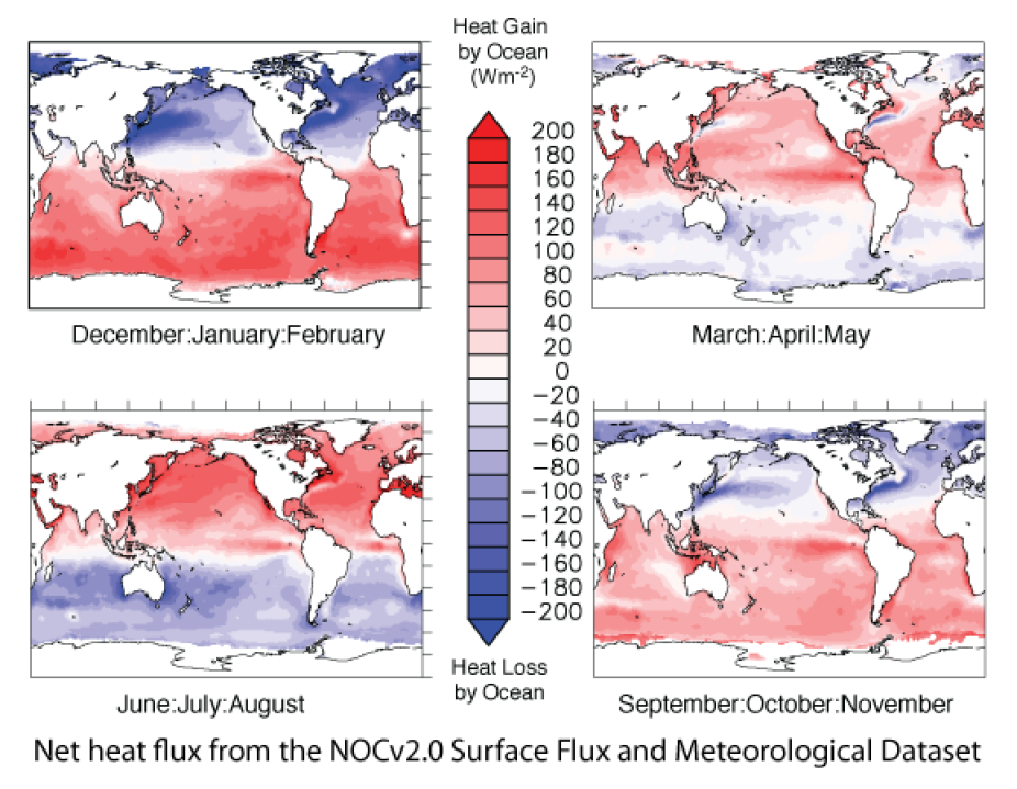
Net heat flux from the NOCv2.0 Surface Flux and Meteorological Dataset (contributed by E. Kent)
Other Information
- Berry, David I., Elizabeth C. Kent, 2009: A New Air–Sea Interaction Gridded Dataset from ICOADS With Uncertainty Estimates. Bull. Amer. Meteor. Soc., 90, 645–656.
- Berry, D. I. and Kent, E. C. (2011), Air–Sea fluxes from ICOADS: the construction of a new gridded dataset with uncertainty estimates. Int. J. Climatol., 31: 987–1001. doi: 10.1002/joc.2059
- Prytherch et al (2014): A comparison of SSM/I-derived global marine surface-specific humidity datasets. Int. J. Climatol.
- Thorne et al (2011): Guiding the creation of a comprehensive surface temperature resource for 21st century climate science. Bulletin of the American Meteorological Society, 92 (11). ES40-ES47.
- Woodruff et al (2011): ICOADS Release 2.5 and Data Characteristics, Int. J. Climatol., 31(7), 951–967
- Thomas et al (2008): Trends in ship wind speeds adjusted for observation method and height, Int. J. Climatol. 28(6), 747-763
- Kent et al (2007): Metadata from WMO Publication No. 47 and an Assessment of Voluntary Observing Ships Observation Heights in ICOADS, Journal of Atmospheric and Oceanic Technology, 24(2), 214–234
- Worley et al (2005): ICOADS Release 2.1 data and products. Int. J. Climatol., 25, 823-842
- Kent et al (2005): Quantifying Random Errors in Voluntary Observing Ships Meteorological Observations, Int. J. Climatol., 25(7), 843-856
- Berry et al (2004): An analytical model of heating errors in marine air temperatures from ships, Journal of Atmospheric and Oceanic Technology, 21(8), 1198 - 1215
- Kent et al, (1997): Choice of a Beaufort Equivalent Scale. Journal of Atmospheric and Oceanic Technology, 14(2), 228-242