Climate data guide content with tag PODAAC-SST00-1D1M1
 SST (AMSR-E): Sea Surface Temperature from Remote Sensing Systems
Years of record
- to
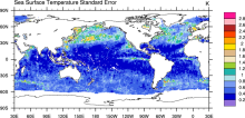
High resolution (0.25°) SSTs were derived from the AMSR-E, a passive microwave radiometer flying on NASA's AQUA satellite. Remote Sensing Systems distributes the data in high spatial and temporal (daily, weekly, monthly) resolutions for both daytime and nighttime averages. Monthly versions are available on a 1°x1° grid from JPL PO-DAAC as well as the CMIP5 obs4MIPS…
Experts contributing reviews
- N/A