COSP: Cloud Feedback Model Intercomparison Project (CFMIP) Observation Simulator Package
Cloud processes and feedbacks are recognized as the largest uncertainty in climate model projections. Progress in understanding the roles of clouds in the response of the Earth to changes in external forcing (GHG, aerosoles, etc.) has in part been hampered by the lack of a consistent definition of clouds and cloud types in models and observations. It has been difficult to compare model output to observations, or even to compare model simulations to each other. The World Climate Research Program's (WCRP) Working Group on Coupled Modeling (WGCM) has recommended that climate models participating in CMIP5 use COSP. COSP includes simulators that are compatible with the ISCCP, PARASOL, CALIPSO, CALIOP, MISR, MODIS, and CloudSat observational products.
Key Strengths
Facilitates "apples-to-apples" comparison of observed cloud data and model-simulated clouds
Can be adapted to many types of numerical models
Key Limitations
Enabling the COSP package can increase the run time of an experiment
Some cloud definition issues still not resolved; for example simulators do not capture differences in optically thin clouds between MODIS and ISCCP due to the latter's inclusion of partly cloudy pixels
Expert User Guidance
The following was contributed by Jennifer Kay (NCAR), May, 2012:
#Cloud processes and feedbacks remain the largest uncertainty in climate model projections. As a result, the Cloud Feedback Model Intercomparison Project (CFMIP), an international effort to understand cloud feedbacks and evaluate climate models with observations, was initiated (Bony et al. 2011). As a part of CFMIP, scientists and software engineers have integrated the CFMIP Observation Simulator Package (COSP, Bodas-Salcedo et al. 2012) into the atmospheric components of global climate models around the world. Many climate modeling centers are now producing diagnostics to contribute to CFMIP. For example, COSP now runs inline within Community Atmosphere Model (CAM), the atmospheric component of NCAR's Community Earth System Model (CESM) (Kay et al. 2012). COSP calculates model cloud diagnostics that can be directly compared with satellite observations from ISCCP, CloudSat, CALIOP, MISR, and MODIS. More information on COSP, including observations for comparison with COSP-simulated fields is available at http://climserv.ipsl.polytechnique.fr/cfmip-obs/.##
Cite this page
Acknowledgement of any material taken from or knowledge gained from this page is appreciated:
Kay, Jennifer & National Center for Atmospheric Research Staff (Eds). Last modified "The Climate Data Guide: COSP: Cloud Feedback Model Intercomparison Project (CFMIP) Observation Simulator Package.” Retrieved from https://climatedataguide.ucar.edu/climate-data/cosp-cloud-feedback-model-intercomparison-project-cfmip-observation-simulator-package on 2026-05-13.
Citation of datasets is separate and should be done according to the data providers' instructions. If known to us, data citation instructions are given in the Data Access section, above.
Acknowledgement of the Climate Data Guide project is also appreciated:
Schneider, D. P., C. Deser, J. Fasullo, and K. E. Trenberth, 2013: Climate Data Guide Spurs Discovery and Understanding. Eos Trans. AGU, 94, 121–122, https://doi.org/10.1002/2013eo130001
Key Figures

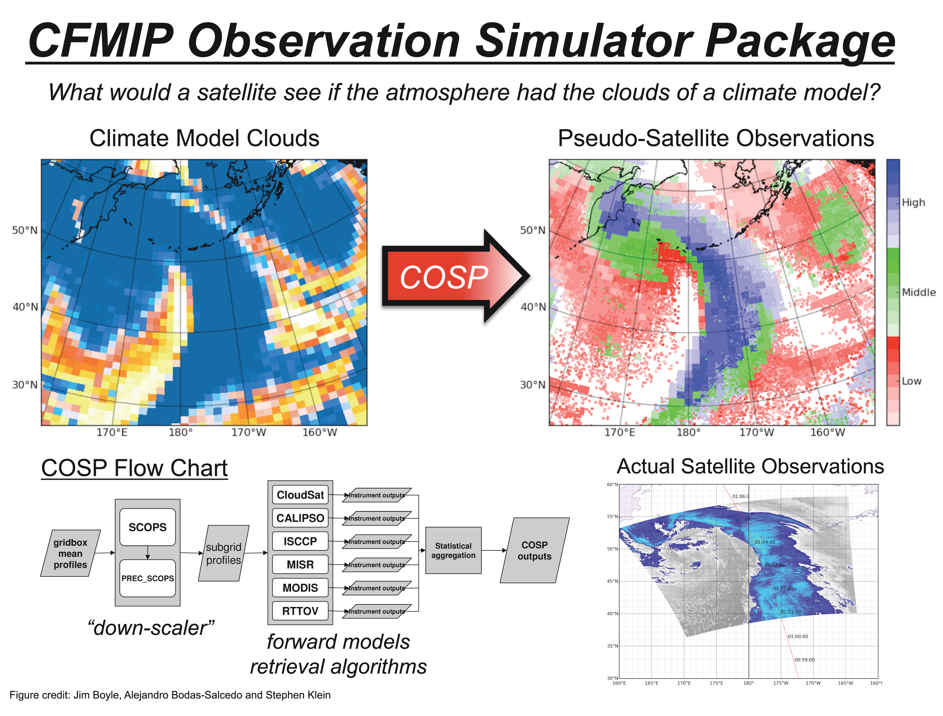
COSP explanation figure (contributed by Steve Klein).
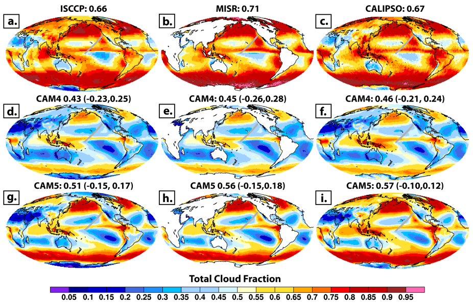
Global maps of observed and COSP-simulated annual mean total cloud fraction: a) ISCCP observations (τ>0.3), b) MISR observations (τ>0.3), c) CALIPSO GOCCP observations (SR > 5), d) CAM4 ISCCP, e) CAM4 MISR, f) CAM4 CALIPSO, g) CAM5 ISCCP, and h) CAM5 MISR, i) CAM5 CALIPSO. based on Kay et al. (2012)
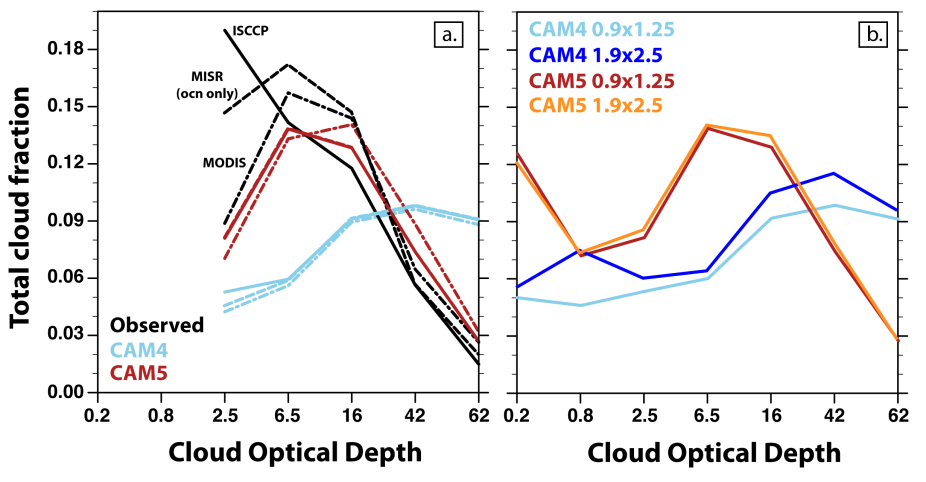
Global column-integrated cloud optical depth (τ) distributions: a) MISR, MODIS, and ISCCP from satellite observations, CAM4, and CAM5, b) ISCCP from CAM4 and CAM5 at both 0.9x1.25 and 1.9x2.5 horizontal grid resolutions. based on Kay et al. 2012. (contributed by Jennifer Kay).
Other Information
- Bodas-Salcedo, A. et al (2011): COSP: A satellite simulation software for model assessment. Bull. Amer. Meteor. Soc., 92, 1023–1043
- Bony, S. et al. (2011), CFMIP: Towards a better evaluation and understanding of clouds and cloud feedbacks in CMIP5 models, CLIVAR Exchanges, 56(2), p 20-22 (pdf file)
- Kay, J.E. et al. (2012): Exposing global cloud biases in the Community Atmosphere Model (CAM) using satellite observations and their corresponding instrument simulators, J. Climate, in press, doi:10.1175/JCLI-D-11-00469.1
- Pincus, Robert, Steven Platnick, Steven A. Ackerman, Richard S. Hemler, Robert J. Patrick Hofmann, 2012: Reconciling Simulated and Observed Views of Clouds: MODIS, ISCCP, and the Limits of Instrument Simulators. J. Climate, 25, 4699–4720.
- Stubenrauch, C., W. Rossow and S. Kinne (2012), Assessment of Global Cloud Data Sets from Satellites, A Project of the World Climate Research Programme Global Energy and Water Cycle Experiment Radiation Panel, WCRP Report No. 23/2012, 176 pp (.pdf).