Japanese Ocean Flux Data sets with Use of Remote Sensing Observations (J-OFURO2)
Cite this page
Acknowledgement of any material taken from or knowledge gained from this page is appreciated:
National Center for Atmospheric Research Staff (Eds). Last modified "The Climate Data Guide: Japanese Ocean Flux Data sets with Use of Remote Sensing Observations (J-OFURO2).” Retrieved from https://climatedataguide.ucar.edu/climate-data/japanese-ocean-flux-data-sets-use-remote-sensing-observations-j-ofuro2 on 2026-02-16.
Citation of datasets is separate and should be done according to the data providers' instructions. If known to us, data citation instructions are given in the Data Access section, above.
Acknowledgement of the Climate Data Guide project is also appreciated:
Schneider, D. P., C. Deser, J. Fasullo, and K. E. Trenberth, 2013: Climate Data Guide Spurs Discovery and Understanding. Eos Trans. AGU, 94, 121–122, https://doi.org/10.1002/2013eo130001
Key Figures
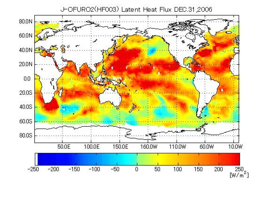
J-OFURO2 derived latent heat flux for December 31, 2006. (Downloaded from J-OFURO2 website)
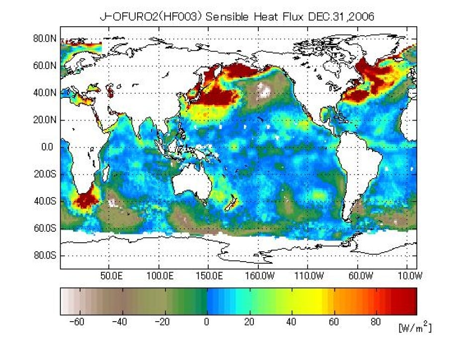
J-OFURO2 derived sensible heat flux for December 31, 2006. (Downloaded from J-OFURO2 website)
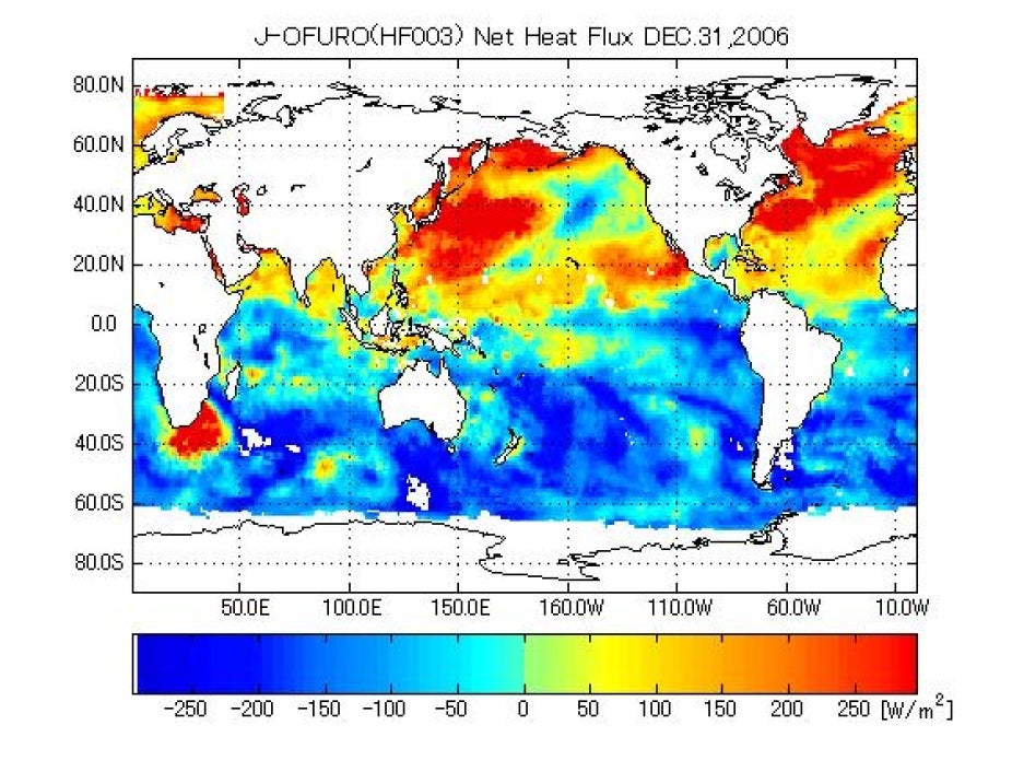
J-OFURO2 derived net heat flux for December 31, 2006. (Downloaded from J-OFURO2 website)
J-OFURO2 derived net heat flux for December 31, 2006. (Downloaded from J-OFURO2 website)
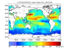
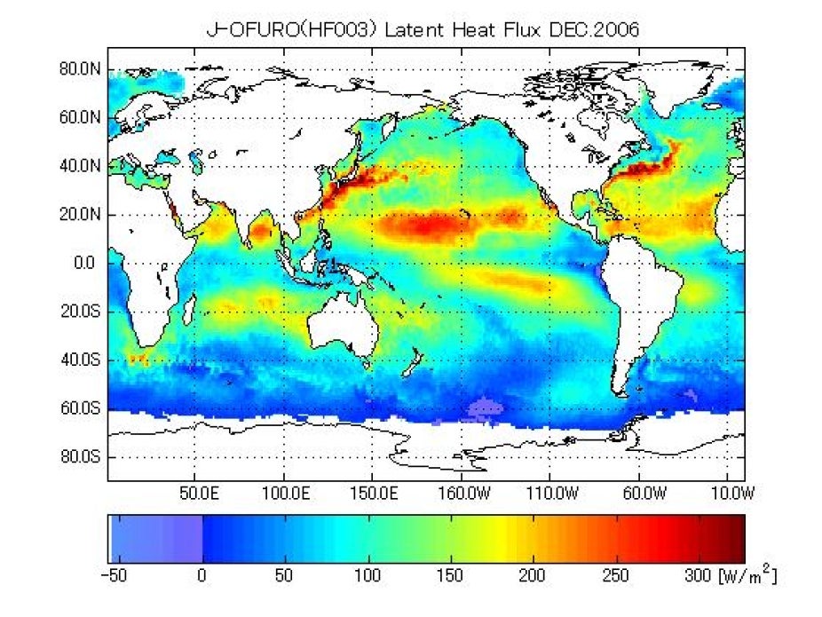
J-OFURO2 derived monthly mean latent heat flux for December 2006. (Downloaded from J-OFURO2 website)

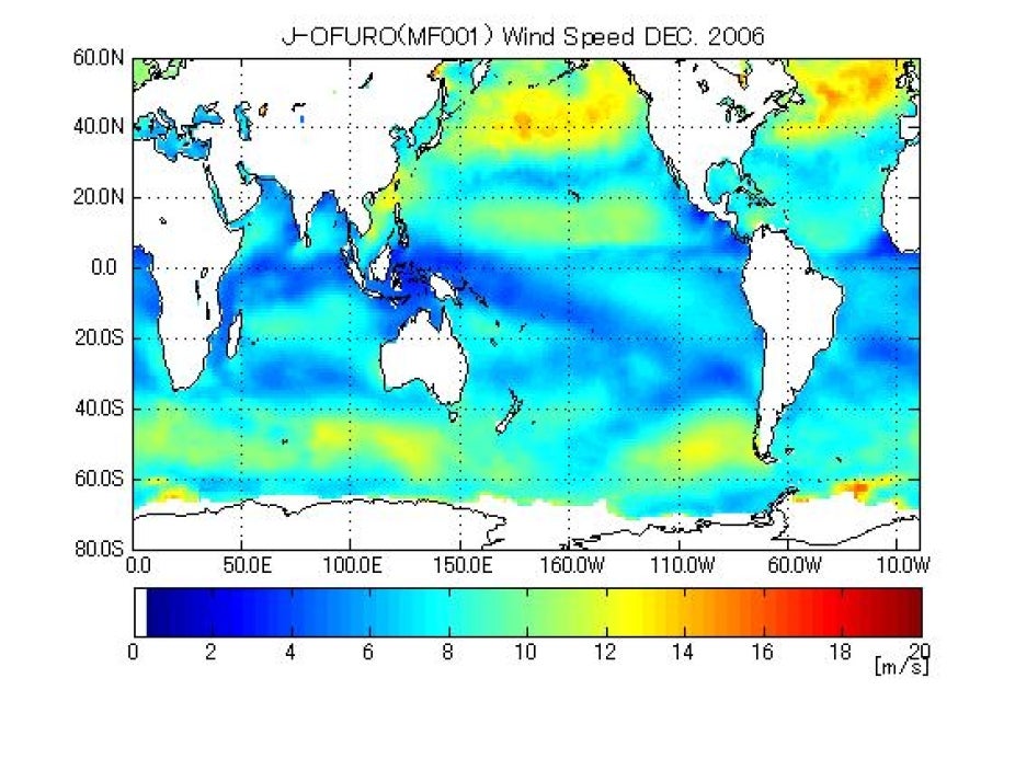
J-OFURO2 derived monthly mean wind speed for December 2006. (Downloaded from J-OFURO2 website)
Other Information
- Tomita, H. and M. Kubota(2011): Sampling error of daily mean surface wind speed and air specific humidity due to sun-synchronous satellite sampling and its reduction by multi-satellite sampling. Int. J. Remote Sens.
- Iwasaki, S., M. Kubota, and H. Tomita (2010):Evaluation of bulk method for satellite-derived latent heat flux, J. Geophys. Res.-Ocean, 115, C07007
- Tomita, H., M. Kubota, M. F. Cronin, S. Iwasaki, M. Konda, H. Ichikawa (2010): An assessment of surface heat fluxes from J-OFURO2 at the KEO/JKEO sites. J. Geophys. Res., 115,C03018
- Fairall, C. W., E. F. Bradley, J. E. Hare, A. A. Grachev, and J. B. Edson (2003), Bulk parameterization of air-sea fluxes: Updates and verification for the COARE algorithm, J. Clim., 16, 571–591