Climate data guide content with tag sc-PDSI
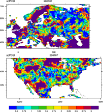 CRU sc-PDSI (self-calibrating PDSI) over Europe & North America
Years of record
- to
Maps of the monthly self-calibrating Palmer drought severity index (SCPDSI) have been calculated for the period 1901–2002 for the contiguous United States (20°–50°N and 130°–60°W) and Europe (35°–70°N, 10°W–60°E) with a spatial resolution of 0.5° × 0.5°
-
Formats
- ascii
-
Timestep
- Monthly
-
Domain
- Europe, North America
-
Collections
- N/A
Experts contributing reviews
- N/A