Climate data guide content with tag ENVISAT
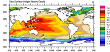 AVISO: Satellite derived Sea Surface Height above Geoid
Years of record
- to
The sea surface height relative to the geoid (the mean ocean surface of the Earth if the ocean is at rest) is derived from TOPEX/Poseidon, Envisat, Jason-1, and OSTM/Jason-2 altimetry measurements. Altimetry is a technique for measuring height. Satellite altimetry measures the time taken by a radar pulse to travel from the satellite antenna to the surface and back to…
Experts contributing reviews
- N/A
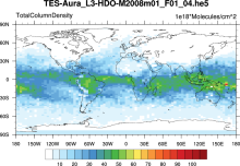 Water Isotopes from Satellites
Years of record
- to
Summary of 7 satellite-derived products providing a global snapshot of water isotope distribution in 3D, with good information on zonal gradients and seasonality.
Experts contributing reviews
- Risi, Camille