Climate data guide content with tag Sea Level
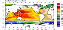 AVISO: Satellite derived Sea Surface Height above Geoid
Years of record
- to
The sea surface height relative to the geoid (the mean ocean surface of the Earth if the ocean is at rest) is derived from TOPEX/Poseidon, Envisat, Jason-1, and OSTM/Jason-2 altimetry measurements. Altimetry is a technique for measuring height. Satellite altimetry measures the time taken by a radar pulse to travel from the satellite antenna to the surface and back to…
Experts contributing reviews
- N/A
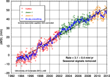 Global Mean Sea Level from TOPEX & Jason Altimetry
Years of record
- to
The global mean sea level timeseries is an excellent, integrative indicator of long-term global temperature trends, providing a record that is observed and processed independent of common metrics like global surface air temperature. The major contributions to the observed sea level trend of 3.3 mm/year include the ocean's thermal expansion, meltwater from mountain…
Experts contributing reviews
- Nerem, R.S.
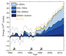
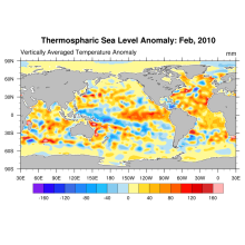 Global Ocean Heat and Thermospheric Sea Level Change
Years of record
- to
Using updated data from the World Ocean Database (Boyer et al, 2009) and improved ARGO profiling data, new estimates of ocean heat content and thermospheric sea level change (0-2000m) for the period 1955-2010 are derived.
Experts contributing reviews
- N/A
 Ocean temperature analysis and heat content estimate from Institute of Atmospheric Physics
Years of record
- to
The Institute of Atmospheric Physics (IAP) ocean temperature analysis features global coverage of the oceans, at 1° x1° horizontal resolution on 41 vertical levels from 1-2000m, and monthly resolution from 1940 to present. As such, it is aimed at studies of climate variability and change, from large regional to global scales, on timescales of months to decades.…
Main variables and Earth System components
Ocean Ocean Heat Content Sea Level Sub Surface TemperatureExperts contributing reviews
- Cheng, Lijing
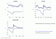 ORAS4: ECMWF Ocean Reanalysis and derived ocean heat content
Years of record
- to
ECMWF's current ocean reanalysis uses a sophisticated data assimilation methodology which includes a model bias correction. The ocean model used is forced by atmospheric daily surface fluxes, relaxed to SST and bias corrected. The Balmaseda et al (QJRMS 2013) reference provides excellent peer reviewed documentation and evaluation.
Main variables and Earth System components
Ocean Ocean Heat Content Salinity Sea Level potential temperature u, v current components-
Timestep
- Monthly
-
Domain
- Global
-
Collections
- Climate Analysis Section (CAS) Data Catalog
Experts contributing reviews
- N/A
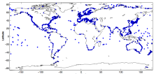 Tide gauge sea level data
Years of record
- to
The global sea level record from tide gauges is an important indicator of the evolution and impact of global change. Tide gauge data also capture a variety of local and regional phenomena related to decadal climate variability, tides, storm surges, tsunamis, swells, and other coastal processes. Tide gauge data are used to validate ocean models and to detect…
-
Formats
- N/A
-
Timestep
- Sub-daily, Daily, Monthly, Annual
-
Domain
- Global
-
Collections
- N/A
Experts contributing reviews
- Hamlington, Benjamin, Thompson, Phil