LANDSAT

"The Landsat Program provides the longest continuous space-based record of Earth’s land in existence. Since 1972, Landsat satellites have collected measurements of Earth’s continents and surrounding coastal regions that have enabled people to study forests, food production, water and land use, ecosystems, geology, and more. The long data record allows scientists to evaluate the dynamic changes caused by both natural processes and human practices. The Landsat Program is jointly managed by the U.S. Geological Survey and NASA." Landsat 8 (formerly the Landsat Data Continuity Mission) was launched on February 11, 2013. It joined Landsat 7 orbiting the earth. These satellites continue to deliver visually stunning and scientifically valuable images of our planet. These data allow scientists to assess changes in Earth’s landscape.
Key Strengths
“Landsat imagery courtesy of NASA Goddard Space Flight Center and U.S. Geological Survey” or “USGS/NASA Landsat”
Cite this page
Acknowledgement of any material taken from or knowledge gained from this page is appreciated:
National Center for Atmospheric Research Staff (Eds). Last modified "The Climate Data Guide: LANDSAT.” Retrieved from https://climatedataguide.ucar.edu/climate-data/landsat on 2026-03-05.
Citation of datasets is separate and should be done according to the data providers' instructions. If known to us, data citation instructions are given in the Data Access section, above.
Acknowledgement of the Climate Data Guide project is also appreciated:
Schneider, D. P., C. Deser, J. Fasullo, and K. E. Trenberth, 2013: Climate Data Guide Spurs Discovery and Understanding. Eos Trans. AGU, 94, 121–122, https://doi.org/10.1002/2013eo130001
Key Figures
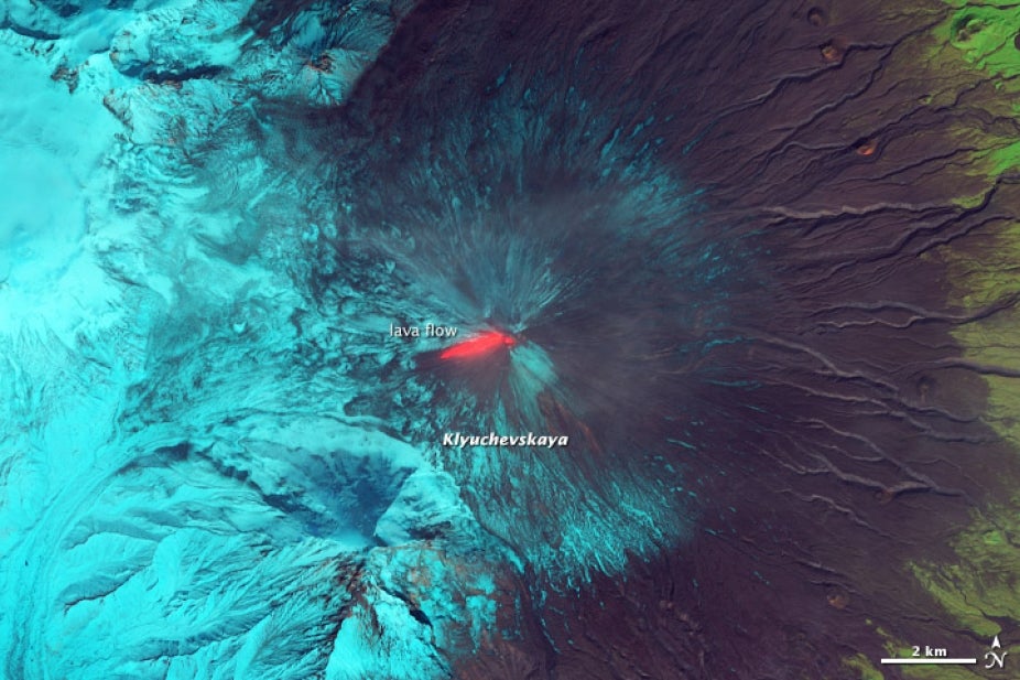
"This false-color (shortwave infrared, near infrared, and green) satellite image reveals an active lava flow on the western slopes of Klyuchevskaya, one of several active volcanoes on the Kamchatka Peninsula in far eastern Russia. The lava flow itself is bright red. Snow on Klyuchevskaya and nearby mountains is cyan, while bare ground and volcanic debris is gray or brown. Vegetation is green. The image was collected by Landsat 8 on September 9, 2013. NASA Earth Observatory image by Jesse Allen and Robert Simmon, using Earth Explorer." (source: USGS/NASA Landsat)
Other Information
- Nemani,R. et al (2009): Monitoring and forecasting ecosystem dynamics using the Terrestrial Observation and Prediction System (TOPS) . Remote Sensing of Environment 113 (2009) 1497 – 1509
- Running, S.W, et al (2004): A Continuous Satellite-Derived Measure of Global Terrestrial Primary Production. June 2004 / Vol. 54 No. 6 • BioScience
- Zhao, M. et al (2005): Improvements of the MODIS terrestrial gross and net primary production global data set. Remote Sensing of Environment, Vol. 95, No. 2. (March 2005), pp. 164-176
- Zhao, M and S.W. Running (2010): Drought-induced reduction in global terrestrial net primary production from 2000 through 2009. Science, Vol. 329, No. 5994. (August 2010), pp. 940-3