Climate data guide content with tag Land Cover Type
 Carbon Emissions from Historical Land-Use and Land-Use Change
Years of record
- to
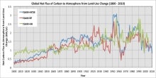
Annual net land-atmosphere carbon flux and net flux of carbon to the atmosphere due to land-use and land-use change (LULUC) are estimated using an integrated assessment model and three historical reconstructions of land use and land use conversion. The data span 1800-2010 and are aggregated for nine regions of the globe.
Main variables and Earth System components
Biosphere CO2 Land CO2 Land-Atmosphere flux Land Cover Type Land Use ConversionExperts contributing reviews
- Meiyappan, Prasanth
 CERES: IGBP Land Classification
Years of record
- N/A
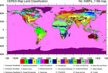
The International Geosphere–Biosphere Programme (IGBP) defines ecosystems surface classifications. The CERES (Clouds and Earth's Radiant Energy System)10-minute data can be used to derive the land categories.
Experts contributing reviews
- N/A
 Historical land-cover changes and land-use conversions global data set by Meiyappan and Jain
Years of record
- to
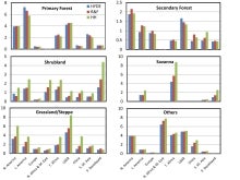
A set of three estimates of land-cover types and annual transformations of land use are provided on a global 0.5°x0.5° grid at annual timesteps. The longest of the three estimates spans 1770-2010. The three estimates use three different data sets of cropland and pastureland. Common input data sets are of wood harvest and urban land. The three estimates use a consistent…
Main variables and Earth System components
Land Land Cover Type Land Use Conversion Vegetation CoverExperts contributing reviews
- Meiyappan, Prasanth
 LANDSAT
Years of record
- to
"The Landsat Program provides the longest continuous space-based record of Earth’s land in existence. Since 1972, Landsat satellites have collected measurements of Earth’s continents and surrounding coastal regions that have enabled people to study forests, food production, water and land use, ecosystems, geology, and more. The long data record allows scientists to…
Main variables and Earth System components
Biosphere NPP: Net Primary Production Land Land Cover Type Vegetation Cover-
Formats
- N/A
-
Timestep
- Sub-daily
-
Domain
- Global
-
Collections
- Carbon cycle
Experts contributing reviews
- N/A