Climate data guide content with tag Biosphere
 AIRS and AMSU: Trace Gases (CO2, CO, CH4, O3...); Level 3
Years of record
- N/A
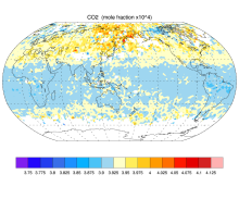
AIRS provides satellite retrieval of mid-tropospheric carbon dioxide even under cloudy conditions, without the use of a priori information from models. AIRS retrievals use cloud-cleared thermal IR radiance spectra in the 15 micron band with an accuracy better than 2 ppm. AIRS retrievals have been used to produce global maps of carbon dioxide and other trace gases…
Main variables and Earth System components
Atmosphere CO Ozone: Tropospheric Biosphere CH4-Methane CO CO2-
Timestep
- Sub-daily, Daily, Monthly
-
Domain
- Global
-
Collections
- Carbon cycle
Experts contributing reviews
- N/A
 An overview of paleoclimate information from high-resolution lake sediment records: Strengths, limitations and key databases
Years of record
- N/A
Accumulated sediments at the bottom of lakes are invaluable archives of past climate and environmental change. These sediments contain a variety of physical, geochemical, and biological proxy indicators that can be used to gain a multi-faceted understanding of past conditions. Unlike other high-resolution paleoclimate archives, such as tree rings, corals, and…
Main variables and Earth System components
Atmosphere Air Temperature Precipitation Biosphere Pollen Land-
Formats
- ascii, csv, Linked Paleo Data (LiPD)
-
Timestep
- Annual, Decadal, Irregular
-
Domain
- Global
-
Collections
- N/A
Experts contributing reviews
- Larocca, Laura, Broadman, Ellie
 Carbon Emissions from Historical Land-Use and Land-Use Change
Years of record
- to
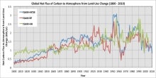
Annual net land-atmosphere carbon flux and net flux of carbon to the atmosphere due to land-use and land-use change (LULUC) are estimated using an integrated assessment model and three historical reconstructions of land use and land use conversion. The data span 1800-2010 and are aggregated for nine regions of the globe.
Main variables and Earth System components
Biosphere CO2 Land CO2 Land-Atmosphere flux Land Cover Type Land Use ConversionExperts contributing reviews
- Meiyappan, Prasanth
 Global dataset of solar-induced chlorophyll fluorescence (GOSIF)
Years of record
- to
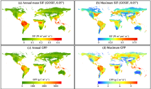
GOSIF is a global, gridded dataset of solar-induced chlorophyll fluorescence (SIF). SIF, an energy flux re-emitted by plants a few nanoseconds after light absorption, exhibits a strong linear relationship with gross primary production (GPP) at the ecosystem scale and thereby is a strong proxy of GPP. The GOSIF dataset (Li and Xiao, 2019a) provides 8-day SIF data…
Main variables and Earth System components
Biosphere GPP: Gross Primary Production solar-induced chlorophyll fluorescence (SIF) Land Gross Primary Production-
Formats
- N/A
-
Timestep
- Monthly, Weekly
-
Domain
- Global
-
Collections
- N/A
Experts contributing reviews
- Xiao, Jingfeng, Li, Xing
 Global Land Evaporation Amsterdam Model (GLEAM)
Years of record
- to
The Global Land Evaporation Amsterdam Model (GLEAM) is a satellite remote sensing-based set of algorithms dedicated to the estimation of evaporation and soil moisture at global scales (Miralles et al. 2011). The current version of GLEAM (version 3) operates at a daily time step with a spatial resolution of 0.25 degrees (Martens et al. 2017). The dataset consists of two…
Main variables and Earth System components
Biosphere land evaporation Land evapotranspiration Soil Moisture-
Formats
- N/A
-
Timestep
- Daily
-
Domain
- Global
-
Collections
- N/A
Experts contributing reviews
- Miralles, Diego, Koppa, Akash
 Harmonized Soil Carbon Database
Years of record
- N/A
"This state-of-the-art database was established by IIASA and FAO in partnership with: ISRIC-World Soil Information which, together with the FAO, contributed recent regional soil and terrain databases together with the WISE soil profile database; The European Soil Bureau Network, which provided its major new update of soil information for Europe and northern Eurasia;…
-
Formats
- netCDF, ARC/INFO ASCII GRID
-
Timestep
- N/A
-
Domain
- Global
-
Collections
- Carbon cycle
Experts contributing reviews
- N/A
 LANDSAT
Years of record
- to
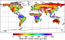
"The Landsat Program provides the longest continuous space-based record of Earth’s land in existence. Since 1972, Landsat satellites have collected measurements of Earth’s continents and surrounding coastal regions that have enabled people to study forests, food production, water and land use, ecosystems, geology, and more. The long data record allows scientists to…
Main variables and Earth System components
Biosphere NPP: Net Primary Production Land Land Cover Type Vegetation Cover-
Formats
- N/A
-
Timestep
- Sub-daily
-
Domain
- Global
-
Collections
- Carbon cycle
Experts contributing reviews
- N/A
 Making sense of data from Land Surface Models (LSMs)
Years of record
- N/A
The land surface is a dynamic and complex component of the Earth system, shaping climate and biogeochemical cycles and serving as the origin of many anthropogenic impacts on the planet. Comprising complex and interactive organic and inorganic systems (soils, rocks, water in all phases, vegetation, and animals) the land surface shapes and is shaped by the fluid envelope…
-
Formats
- N/A
-
Timestep
- N/A
-
Domain
- N/A
-
Collections
- N/A
Experts contributing reviews
- Mankin, Justin, Lesk, Corey
 MODIS GPP/NPP Project (MOD17)
Years of record
- to
The goal of the MOD17 MODIS project is to provide continuous estimates of Gross/Net Primary Production (GPP/NPP) across Earth’s entire vegetated land surface. MOD17 GPP/NPP outputs are useful for natural resource and land management, global carbon cycle analysis, ecosystem status assessment, and environmental change monitoring. MOD17 is part of the NASA Earth…
Experts contributing reviews
- N/A
 Overview: Carbon Dioxide (CO2) Data Sets
Years of record
- to
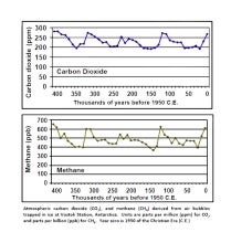
Directly measured and continuous records of atmospheric carbon dioxide (CO2) extend back to 1958. CO2 has also been measured in ancient air samples trapped in ice cores, and these records extend back hundreds of thousands of years. More recently, CO2 is being sampled by satellites providing global data to researchers.
-
Formats
- ascii
-
Timestep
- Daily, Monthly, Annual
-
Domain
- N/A
-
Collections
- Boundary Conditions, Carbon cycle, Overview / Comparison page
Experts contributing reviews
- N/A
 SCRIPPS O2 ,CO2 and APO
Years of record
- to
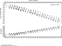
"The Scripps O2Program measures changes in atmospheric oxygen levels from air samples collected at stations around the world. This sampling network provides a global and hemispheric perspective on oxygen variability. " Stations include: Alert, NWT, Canada Cold Bay, Alaska Cape Kumukahi, Hawaii La Jolla Pier, California Mauna Loa Observatory,Hawaii American Samoa Cape…
-
Formats
- ascii
-
Timestep
- Daily, Monthly
-
Domain
- N/A
-
Collections
- Carbon cycle
Experts contributing reviews
- N/A
 SOCAT: Surface Ocean CO2 Atlas
Years of record
- to
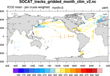
SOCAT (Surface Ocean CO2 Atlas) represents an effort to "provide a comprehensive, publicly available, regularly updated, global data set of marine surface CO2, which had been subject to quality control (QC)." The data sets are comprised of observations (ship track) and gridded data.
-
Formats
- netCDF
-
Timestep
- Climatology, Monthly, Annual
-
Domain
- Global
-
Collections
- Carbon cycle
Experts contributing reviews
- N/A