Lightning data from the TRMM and ISS Lightning Image Sounder (LIS): Towards a global lightning Climate Data Record
The Lightning Imaging Sensor (LIS) is an optically based spaceborne lightning detection instrument that has been hosted on two different platforms – the Tropical Rainfall Measuring Mission satellite (TRMM; 1998-2015; Kummerow et al. 1998) and the International Space Station (ISS; 2017-present; Blakeslee et al. 2020). Relative to TRMM LIS, which covered ±38 latitude, ISS LIS extends the program of record for global coverage of lightning to higher latitudes (up to ±55). Unfortunately, the two sensors did not overlap in orbit, so there is a couple year gap in the climatological record of tropical and subtropical lightning. The ISS LIS mission is scheduled to end in December 2023. After the end of the ISS LIS mission, the TRMM and ISS LIS datasets will be reprocessed and harmonized with each other and the Optical Transient Detector dataset (OTD; 1995-2000; Christian et al. 2003). This will extend existing TRMM LIS and OTD climatologies (Cecil et al. 2014, Albrecht et al. 2016), creating a fully merged and harmonized ~28-year climate data record of global lightning from space.
Key Strengths
Total (intracloud + cloud-to-ground) lightning detection with high (~60-70%), spatially uniform detection efficiency (e.g., same over land vs. ocean).
Global coverage up to +/- 38-55 degrees latitude
Key Limitations
No continuous coverage of individual storms due to low-Earth orbit; storms are in field of view for only ~90 seconds
Detection efficiency may be reduced in intense storms with high flash rates, due to frequent optically dim pulses
The current LIS-based record is not temporally consistent, as the the TRMM-era and ISS-era instruments did not overlap
Expert Developer Guidance
The following was contributed by Timothy Lang and Dennis Buechler, June, 2023:
The Lightning Imaging Sensor (LIS) is an optically based spaceborne lightning detection instrument that has been hosted on two different platforms – the Tropical Rainfall Measuring Mission satellite (TRMM; 1998-2015; Kummerow et al. 1998) and the International Space Station (ISS; 2017-present; Blakeslee et al. 2020). The instrument consists of a high-speed camera (500-fps) that uses a narrowband filter around the 777.4-nm emission line, which enables detection of lightning during both day and night. Lightning is identified and mapped by differencing individual frames against a running-mean background. Lightning Events are defined as individual pixels that have valid signal above the background. Groups are collections of adjacent Events that occur in the same frame, and Flashes are spatiotemporally coherent sets of Groups. Spatial resolution of the instrument is ~4 km at nadir, with a field of view that is approximately 600x600 km2. Temporal resolution is 2 ms. Flash detection efficiency of TRMM LIS was ~70%. Detection efficiency of ISS LIS is somewhat lower (~60%), largely due to platform altitude and pointing angle differences, which reduce ISS LIS sensitivity.
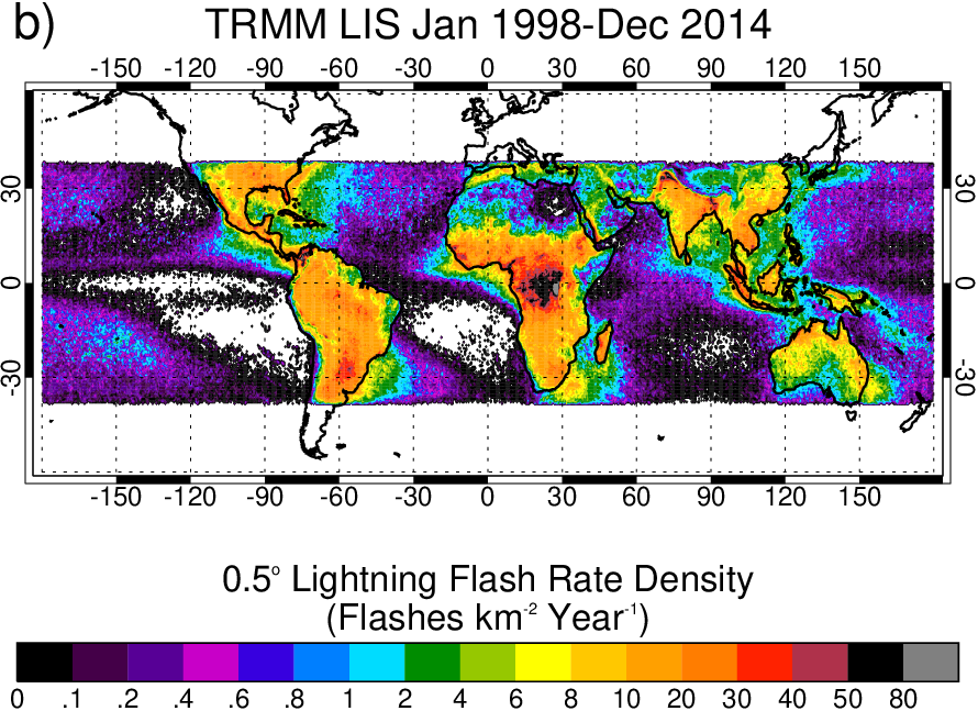
Level 2 LIS data (Events, Groups, and Flashes) are provided as individual orbit granules. The primary data format is netCDF, though an older version of HDF (HDF4-EOS) is also provided to support legacy applications. Via integration of multiple orbits, and then correcting for viewing time and detection efficiency, global climatologies of lightning can be developed (Fig. 1). Relative to TRMM LIS, which covered ±38 latitude, ISS LIS extends the program of record for global coverage of lightning to higher latitudes (up to ±55). Unfortunately, the two sensors did not overlap in orbit, so there is a couple year gap in the climatological record of tropical and subtropical lightning (Fig. 2).
TRMM LIS data have already undergone full quality control (QC) and are distributed by the NASA Global Hydrometeorology Resource Center (GHRC) Distributed Active Archive Center (DAAC). Because ISS LIS is an ongoing mission as of this writing, data are provided by GHRC as three different versions. The near-realtime (NRT) data are distributed as 2-minute granules, and are suitable for timely applications such as weather forecasting/monitoring. The non-quality-controlled (NQC) data are updated daily, and include the full orbit granules with no QC. Full QC data are updated approximately 3-6 months after they are obtained.
All QC LIS data have been reviewed manually by a LIS scientist. Daily browse imagery for both instruments are provided by the GHRC. Both instruments also provide background images as separate datasets. These are individual camera frames that update every 30-60 seconds, providing context about what LIS was viewing at the time (e.g., nighttime darkness; daytime cloud views; clear terrain, water, or coastlines; etc.). ISS LIS data contain viewtime corrections when ISS solar panels partially obstruct its field of view, which occurs periodically every orbit.
The ISS LIS mission is scheduled to end in December 2023. After the end of the ISS LIS mission, the TRMM and ISS LIS datasets will be reprocessed and harmonized with each other and the Optical Transient Detector dataset (OTD; 1995-2000; Christian et al. 2003). This will extend existing TRMM LIS and OTD climatologies (Cecil et al. 2014, Albrecht et al. 2016), creating a fully merged and harmonized ~28-year climate data record of global lightning from space.
Cite this page
Acknowledgement of any material taken from or knowledge gained from this page is appreciated:
Lang, Timothy & National Center for Atmospheric Research Staff (Eds). Last modified "The Climate Data Guide: Lightning data from the TRMM and ISS Lightning Image Sounder (LIS): Towards a global lightning Climate Data Record.” Retrieved from https://climatedataguide.ucar.edu/climate-data/lightning-data-trmm-and-iss-lightning-image-sounder-lis-towards-global-lightning on 2026-07-07.
Citation of datasets is separate and should be done according to the data providers' instructions. If known to us, data citation instructions are given in the Data Access section, above.
Acknowledgement of the Climate Data Guide project is also appreciated:
Schneider, D. P., C. Deser, J. Fasullo, and K. E. Trenberth, 2013: Climate Data Guide Spurs Discovery and Understanding. Eos Trans. AGU, 94, 121–122, https://doi.org/10.1002/2013eo130001
Key Figures
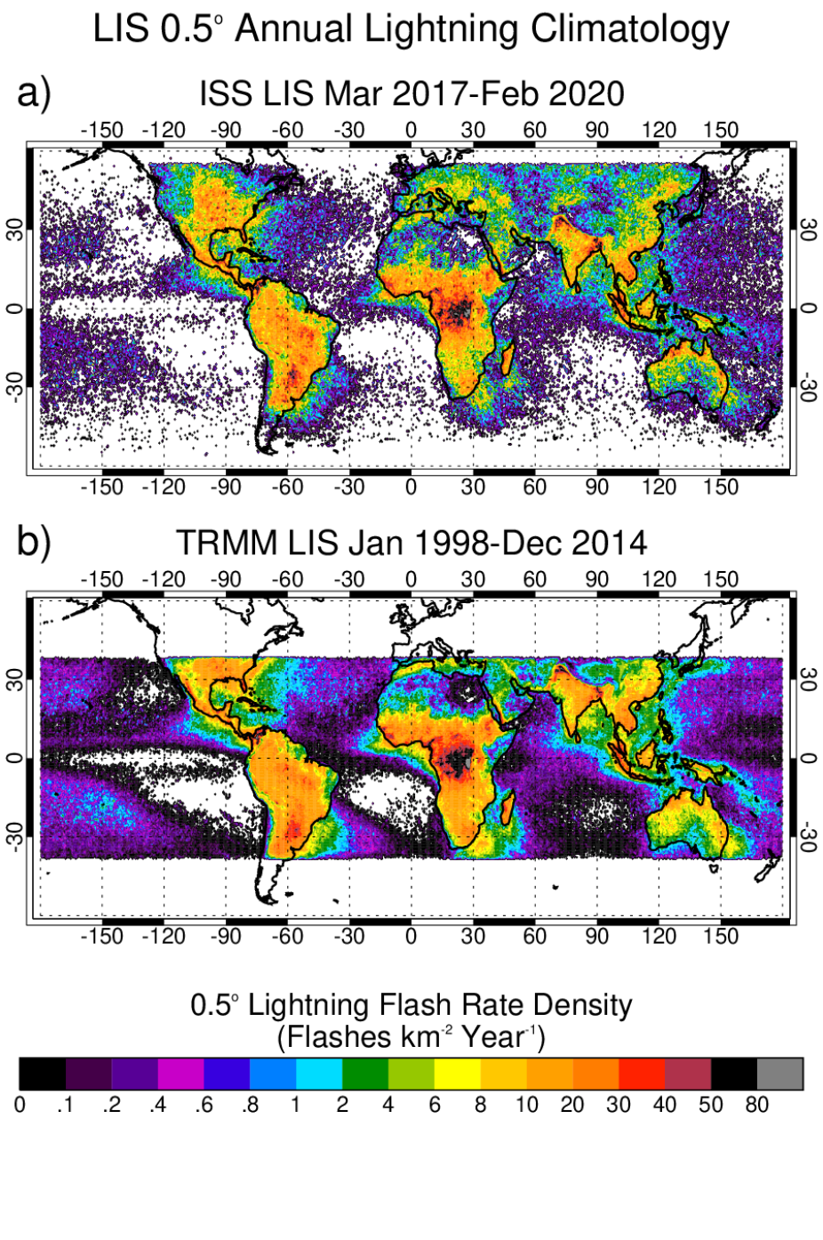
Figure 1. a) Three-year (March 2017 through February 2020) climatology of global lightning from ISS LIS. b) Post-boost climatology of lightning from TRMM LIS (September 2001 through December 2014). Taken from Blakeslee et al. (2020). (credit: Dennis Buechler)
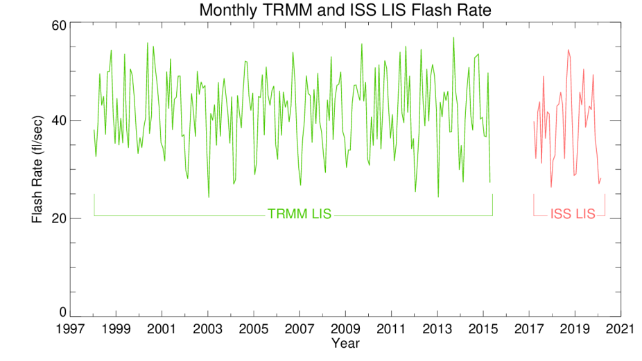
Figure 2. Monthly time series of global lightning flash rate (between ± 38 latitude) from TRMM LIS and ISS LIS. Taken from Blakeslee et al. (2020).
(credit: Dennis Buechler)
Other Information
- Albrecht, R. I., S. J. Goodman, D. E. Buechler, R. J. Blakeslee, and H. J. Christian, 2016: Where Are the Lightning Hotspots on Earth?. Bull. Amer. Meteor. Soc., 97, 2051–2068, https://doi.org/10.1175/BAMS-D-14-00193.1.
- Blakeslee, R.J., Lang, T.J., Koshak, W.J., Buechler, D and Coauthors: (2020), Three Years of the Lightning Imaging Sensor Onboard the International Space Station: Expanded Global Coverage and Enhanced Applications. J. Geophys. Res. Atmos., 125: e2020JD032
- Cecil, D. J., Buechler, D. E., & Blakeslee, R. J. (2014). Gridded lightning climatology from TRMM-LIS and OTD: Dataset description. Atmospheric Research, 135, 404-414. https://doi.org/10.1016/j.atmosres.2012.06.028
- Christian, H. J., et al., Global frequency and distribution of lightning as observed from space by the Optical Transient Detector, J. Geophys. Res., 108( D1), 4005, doi:10.1029/2002JD002347, 2003.
- Kummerow, C., W. Barnes, T. Kozu, J. Shiue, and J. Simpson, 1998: The Tropical Rainfall Measuring Mission (TRMM) Sensor Package. J. Atmos. Oceanic Technol., 15, 809–817, https://doi.org/10.1175/1520-0426(1998)015<0809:TTRMMT>2.0.CO;2