NLDAS: North American Land Data Assimilation System

The North American Land Data Assimilation System (NLDAS) integrates a large quantity of observation-based and model reanalysis data to produce long-term hourly atmospheric forcing data, and then uses this meteorological data to drive offline (not coupled to the atmosphere) land-surface and/or hydrological models. The spatial resolution of NLDAS is at 1/8th-degree grid spacing over the continental United States, southern Canada, and northern Mexico (25-53 North), enabled by the Land Information System (LIS) software framework (Kumar et al., 2006). The four models consist of NASA’s Mosaic land surface model, NOAA’s Noah land surface model, the NWS SAC hydrological model, and the community VIC hydrological model in energy mode.
NLDAS is a collaboration project among several groups: NOAA/NCEP/EMC, NASA's Goddard Space Flight Center (GSFC), Princeton University, the NWS Office of Hydrological Development (OHD), the University of Washington, and NCEP's Climate Prediction Center (CPC).
More information is available in the Expert Guidance section of this page, at NASA’s Land Data Assimilation Systems (LDAS) and Land Information System (LIS) websites, as well as NCEP/EMC's NLDAS and drought websites.
Since it offers meteorological variables at high resolution over a record length of many decades, NLDAS is sometimes compared with PRISM and Daymet; see the Expert Guidance, below, for a disambiguation of these data products, as well as the separate Climate Data Guide pages on these products, linked in the "Related pages" sidebar. Two other datasets in this general category, TerraClimate and the Livneh et al. gridded datasets, are also linked in the sidebar; these final two products have unique strengths of their own but are not frequently updated. Of all of these high-resolution products, NLDAS is the least "pure" in that it involves reanalysis and models; the other ones are essentially statistical interpolations of station data. Users looking to avoid the limitations of gridded and modeled data altogether may wish to check out HadISD, a non-interpolated station database.
Key Strengths
Long-term (1979-present) moderate-high spatial resolution hourly data of surface meteorological forcing and four-model outputs
Stable near real-time operational product with 4-day latency and an available long-term archive
Data products were well-evaluated and validated again various observations and are widely used in the meteorology and hydrology community
Key Limitations
Many issues with precipitation; see full list of Key limitations in the Expert Guidance, below, or in the faq of the NLDAS website
Due to the operational nature of the NLDAS-2 system, it is not possible to resolve all the known issues and re-generate datasets
As it is designed for modeling applications, NLDAS is not intended to be used as an independent dataset for monitoring climate variability and change
1. Xia, Y., K. Mitchell, M. Ek, J. Sheffield, B. Cosgrove, E. Wood, L. Luo, C. Alonge, H. Wei, J. Meng, B. Livneh, D. Lettenmaier, V. Koren, Q. Duan, K. Mo, Y. Fan, and D.M. Mocko, 2012a: Continental-scale water and energy flux analysis and validation for the North American Land Data Assimilation System project phase 2 (NLDAS-2): 1. Intercomparison and application of model products. J. Geophys. Res., 117, D03109, doi:10.1029/2011JD016048
2. Please also use additional citation specific for each NLDAS-2 collection being used (details shown under each DOI below)
DOIs associated with various NLDAS data products
David Mocko and Youlong Xia
Expert Developer Guidance
The following was contributed by Youlong Xia and David M. Mocko, June, 2023:
The North American Land Data Assimilation System (NLDAS, Mitchell et al., 2004; Xia et al., 2012a,b) integrates a large quantity of observation-based and model reanalysis data to produce long-term hourly atmospheric forcing data, and then uses this meteorological data to drive offline (not coupled to the atmosphere) land-surface and/or hydrological models. The spatial resolution of NLDAS is at 1/8th-degree grid spacing over the continental United States, southern Canada, and northern Mexico (25-53 North), enabled by the Land Information System (LIS) software framework (Kumar et al., 2006). The four models consist of NASA’s Mosaic land surface model, NOAA’s Noah land surface model, the NWS SAC hydrological model, and the community VIC hydrological model in energy mode. More information is available at NASA’s Land Data Assimilation Systems (LDAS) and Land Information System (LIS) websites, as well as NCEP/EMC's NLDAS and drought websites. NLDAS is a collaboration project among several groups: NOAA/NCEP/EMC, NASA's Goddard Space Flight Center (GSFC), Princeton University, the NWS Office of Hydrological Development (OHD), the University of Washington, and NCEP's Climate Prediction Center (CPC). NLDAS is a core project with support from NOAA's Modeling, Analysis, Predictions, and Projections Program. For NLDAS Phase 2, the NASA/GSFC group led the development of the algorithm to generate the forcing data and produced this data for the retrospective period (January 1979 – December 2008), as well as generated the retrospective Mosaic model simulation. The University of Washington and Princeton University developed the VIC model, and the Princeton group generated the retrospective period VIC model simulation. NCEP/EMC, in collaboration with the University of Washington, made improvements to the Noah model. NCEP/EMC also generated retrospective period model simulations for Noah and OHD’s SAC model. Since the beginning of 2009, NCEP/EMC ran quasi-operational NLDAS-2 to till 2014 and then was transitioned as part of the NCEP operational product suite.
The operational NLDAS-2 system covers a period from 2 January 1979 to present with a ~4-day latency behind real-time. The NLDAS-2 forcing and model outputs have hourly values and a 0.125-degree spatial resolution. The forcing data includes precipitation, 2-m air temperature, 2-m air humidity, downward shortwave and longwave radiation, 10m wind speed, and surface pressure. The land/hydrological models provide water fluxes, energy fluxes, and state variables. Further details can be found in a README Document for the North American Land Data Assimilation System Phase 2 Datasets. The NLDAS-2 products have been comprehensively evaluated for soil moisture (Xia et al., 2014, 2015a), soil temperature (Xia et al., 2013), evapotranspiration (Zhang et al., 2020), snow (Xia et al., 2015b) and streamflow (Xia et al., 2012b). These NLDAS-2 products were widely used for data assimilation, water resources management, and drought monitoring, including for the U.S. Drought Monitor and NCEP Climate Data Center’s drought briefing.
There are some distinct differences between PRISM and Daymet vs NLDAS: (1) NLDAS is hourly product but the PRISM/Daymet is either monthly or daily product, (2) the NLDAS includes all seven surface meteorological variables needed to drive land/hydrological models but PRISM only includes precipitation although Daymet includes many atmosphere variables needed to drive biogeochemical terrestrial model but only three variables can be used in land models, and (3) additional model outputs besides surface meteorological variables. Therefore, these advantages make the NLDAS to become a unique and useful dataset for land-hydrological modeling and water resource management, and drought monitoring and agriculture applications.
Key Strengths
• Long-term (1979-present) moderate-high spatial resolution hourly data of surface meteorological forcing and four-model outputs;
• Stable near real-time operational product with 4-day latency and an available long-term archive;
• There is a strong team and support staff in support of NLDAS data use including software tools, email list, and in-time announcement of data issue and updates;
• Data products were well-evaluated and validated again various observations and are widely used in the meteorology and hydrology community;
• Documentation and publications available at below websites;
Key Limitations
• Unrealistic precipitation along the Canadian side of the U.S.-Canada border during many years;
• Occasional dry spots of precipitation, from gauge quality control issues, resulting in very dry soil moistures at some isolated locations;
• Changes in the behavior of precipitation after 01 January 2012 due to a change in the use of precipitation from US-Mexico precipitation dataset to global precipitation dataset, especially along the U.S.-side of the U.S.-Mexico border, in western mountainous regions, and along coastlines;
• Unrealistically high precipitation in small, localized regions in Texas and the Southeast U.S. for July and Aug 2008;
A full list of known issues, along with further details and some sample images can be found on the NLDAS FAQ: https://ldas.gsfc.nasa.gov/faq/nldas. Unfortunately, due to the operational nature of the NLDAS-2 system, it is not possible to resolve all these issues and re-generate datasets at this time. While produced in near real-time at NOAA, there is no archive of the NLDAS-2 SAC model output available at this time as NLDAS data is kept 1-year data on High Performance Storage System (HPSS) only. The near real-time NLDAS products in GRIB-2 format can be downloaded at NCEP Central Operations website (https://www.nco.ncep.noaa.gov/pmb/products/nldas/) for operational application purposes.##
Cite this page
Acknowledgement of any material taken from or knowledge gained from this page is appreciated:
Xia, Youlong &, Mocko, David & National Center for Atmospheric Research Staff (Eds). Last modified "The Climate Data Guide: NLDAS: North American Land Data Assimilation System.” Retrieved from https://climatedataguide.ucar.edu/climate-data/nldas-north-american-land-data-assimilation-system on 2026-05-22.
Citation of datasets is separate and should be done according to the data providers' instructions. If known to us, data citation instructions are given in the Data Access section, above.
Acknowledgement of the Climate Data Guide project is also appreciated:
Schneider, D. P., C. Deser, J. Fasullo, and K. E. Trenberth, 2013: Climate Data Guide Spurs Discovery and Understanding. Eos Trans. AGU, 94, 121–122, https://doi.org/10.1002/2013eo130001
Key Figures
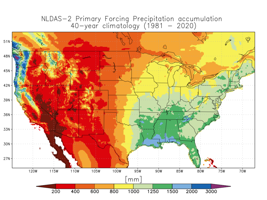
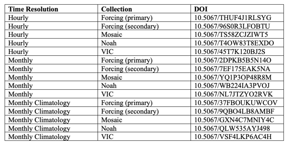
Figure 1. NLDAS-2 Primary Forcing Precipitation annual climatology for 1981-2020. (credit: David Mocko and Youlong Xia)
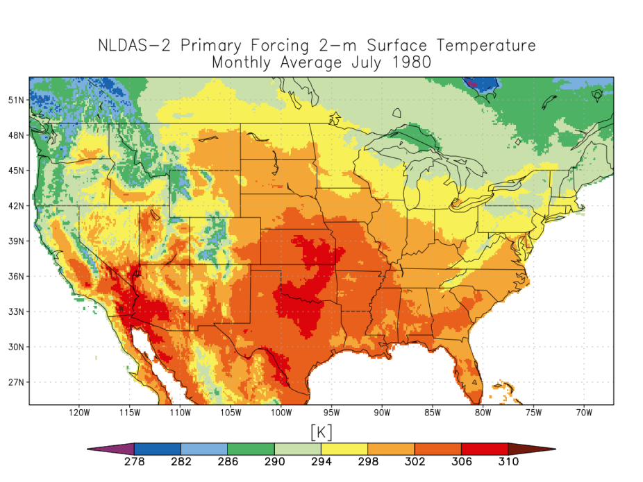
Figure 2: NLDAS-2 Primary Forcing monthly average 2-m surface temperature for July 1980. (credit: David Mocko and Youlong Xia)
Figure 3. NLDAS-2 Mosaic top 1-meter soil moisture on 00Z 15 August 2002. (credit: David Mocko and Youlong Xia.)
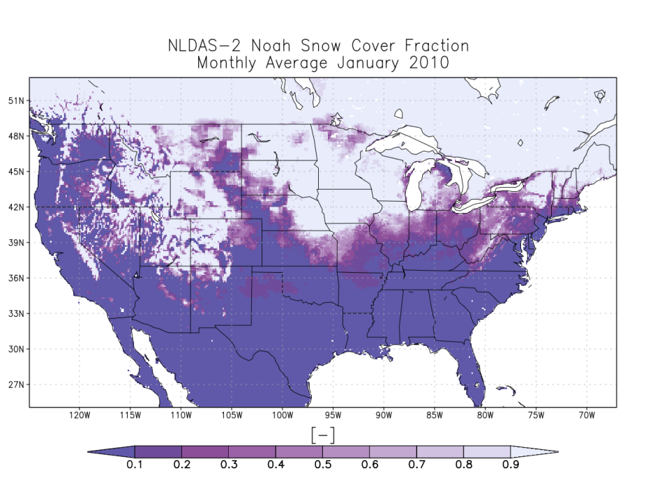
Figure 4. NLDAS-2 Noah monthly average snow cover fraction for January 2010. (credit: David Mocko and Youlong Xia)
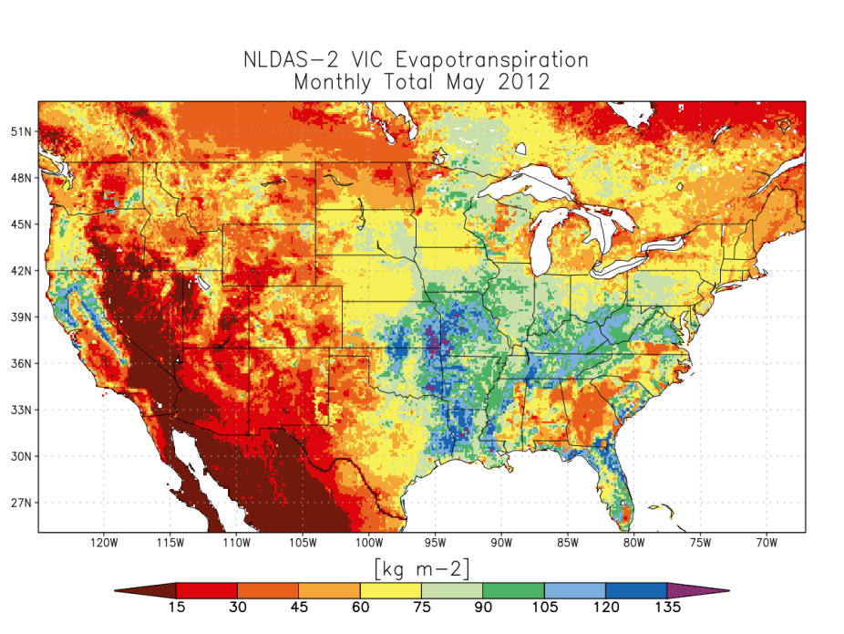
Figure 5. NLDAS-2 VIC monthly total Evapotranspiration for May 2012. (credit: David Mocko and Youlong Xia)
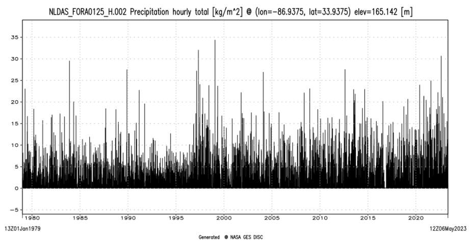
Figure 6. NLDAS-2 Primary Forcing time series of hourly precipitation from 13Z 01 Jan 1979 to 12Z May 2023 at 33.9375 North and -86.9375 West. (credit: David Mocko and Youlong Xia)
Other Information
- KUMAR, S., and Coauthors, 2006: Land information system: An interoperable framework for high resolution land surface modeling. Environmental Modelling & Software, 21, 1402–1415, https://doi.org/10.1016/j.envsoft.2005.07.004.
- Mitchell, K. E., 2004: The multi-institution North American Land Data Assimilation System (NLDAS): Utilizing multiple GCIP products and partners in a continental distributed hydrological modeling system. J. Geophys. Res., 109, https://doi.org/10.1029/2003
- Xia, Y., K. Mitchell, M. Ek, J. Sheffield, B. Cosgrove, E. Wood, L. Luo, C. Alonge, H. Wei, J. Meng, B. Livneh, D. Lettenmaier, V. Koren, Q. Duan, K. Mo, Y. Fan, and D.M. Mocko, 2012a: Continental-scale water and energy flux analysis and validation for th
- Xia, Y., and Coauthors, 2012: Continental-scale water and energy flux analysis and validation for North American Land Data Assimilation System project phase 2 (NLDAS-2): 2. Validation of model-simulated streamflow. J. Geophys. Res., 117, n/a-n/a, https://
- Xia, Y., and Coauthors, 2013: Validation of Noah-Simulated Soil Temperature in the North American Land Data Assimilation System Phase 2. Journal of Applied Meteorology and Climatology, 52, 455–471, https://doi.org/10.1175/jamc-d-12-033.1.
- Xia, Y., J. Sheffield, M. B. Ek, J. Dong, N. Chaney, H. Wei, J. Meng, and E. F. Wood, 2014: Evaluation of multi-model simulated soil moisture in NLDAS-2. Journal of Hydrology, 512, 107–125, https://doi.org/10.1016/j.jhydrol.2014.02.027.
- Xia, Y., M. B. Ek, Y. Wu, T. Ford, and S. M. Quiring, 2015: Comparison of NLDAS-2 Simulated and NASMD Observed Daily Soil Moisture. Part I: Comparison and Analysis. Journal of Hydrometeorology, 16, 1962–1980, https://doi.org/10.1175/jhm-d-14-0096.1.
- Xia, Y., C. D. Peter-Lidard, M. Huang, H. Wei, and M. Ek, 2014: Improved NLDAS-2 Noah-simulated hydrometeorological products with an interim run. Hydrol. Process., 29, 780–792, https://doi.org/10.1002/hyp.10190.
- Zhang, B., Y. Xia, B. Long, M. Hobbins, X. Zhao, C. Hain, Y. Li, and M. C. Anderson, 2020: Evaluation and comparison of multiple evapotranspiration data models over the contiguous United States: Implications for the next phase of NLDAS (NLDAS-Testbed) dev