TerraClimate: Global, high-resolution gridded temperature, precipitation, and other water balance variables
TerraClimate is a global gridded dataset of meteorological and water balance variables for 1958-present, available on a monthly timestep. Its relatively fine spatial resolution, global extent, and long length are a unique combination that fills a void in climate data. TerraClimate combines spatial climatology from WorldClim with time-varying information from the coarser resolution CRU TS4.0.
In addition to maximum and minimum temperatures and precipitation, TerraClimate provides derived variables including reference evapotranspiration, vapor pressure deficit, and PDSI. Water balance metrics including runoff, snow water equivalent, soil moisture, and climatic water deficit are calculated using a Thornthwaite-Mather climatic water-balance model (e.g., Willmott et al., 1985; Dobrowski et al., 2013) and extractable soil water storage capacity data (Wang-Erlandsson et al. 2016).
These data can be used in species distribution modeling, to approximate local variability and changes where station-based data are lacking or derived variables are preferred, and for climate-impact analyses in ecological, agricultural, and hydrological systems cases where spatial attributes of climate may be preferred over coarser resolution data. TerraClimate inherits uncertainties from the input datasets used, and likewise does not improve the spatial scale of climate anomalies over the coarser resolution parent dataset.
Key Strengths
Combines fine spatial resolution climatology with temporal information for 1958-present
In addition to standard monthly climate summaries, TerraClimate provides variables that are of more immediate use to surface hydroclimate for ecology and hydrology including runoff, actual evapotranspiration, soil moisture, and climatic water deficit
Data readily available for download or online visualization
Key Limitations
climatically aided interpolation interpolates anomalies from the coarser resolution parent product (e.g., CRU Ts at 0.5 degree resolution) to the higher-spatial resolution climatology. As such, sharp gradients in climate anomalies in montane or near coastal environments, will not be realized as TerraClimate will not capture temporal variability in climate measures at finer scales than its parent product
TerraClimate should not be viewed to provide an independent estimate of trends in variables such as temperature
Underlying uncertainties in the core datasets used, including negative precipitation biases in mountains of the western US inherited from WorldClim, or inhomogeneities in CRU TS or reanalysis, are entrained into TerraClimate . Also, uses a very simple water balance model.
Abatzoglou, J. T., S. Z. Dobrowski, S. A. Parks, and K. C. Hegewisch, 2018: TerraClimate, a high-resolution global dataset of monthly climate and climatic water balance from 1958–2015. Scientific Data, 5, https://doi.org/10.1038/sdata.2017.191.
Expert Developer Guidance
The following was contributed by Dr. John Abatzoglou, July 2019:
The TerraClimate dataset was developed to fill a void in the availability of freely available moderate-to-high spatial resolution global climate data that spans multiple decades. While datasets with similar attributes are available for individual countries or even continents, the paucity in comparable data across global terrestrial surfaces can be a barrier for end-users who need estimates of place-based climate data such as those often required in ecology and hydrology. TerraClimate provides a six-decade record of monthly climate data for global terrestrial surfaces on a ~4-km (1/24th degree) grid by blending desirable spatial attributes from WorldClimV2 with desirable temporal attributes from CRU Ts4.0 and reanalyses products through climatically aided interpolation.
In addition to providing output of first-order climate measures such as temperature and precipitation, TerraClimate provides derived climate variables that are often of value for climate impact assessments including reference evapotranspiration (Penman-Monteith ASCE), vapor pressure deficit, and PDSI. A modified Thornthwaite-Mather climatic water-balance model (e.g., Willmott et al., 1985; Dobrowski et al., 2013).and extractable soil water storage capacity data (Wang-Erlandsson et al. 2016) are used to compute water balance metrics runoff, snow water equivalent, soil moisture, actual evapotranspiration, and climatic water deficit.
These data can be used in species distribution modeling, to approximate local variability and changes where station-based data are lacking or derived variables are preferred, and for climate-impact analyses in ecological, agricultural, and hydrological systems cases where spatial attributes of climate may be preferred over coarser resolution data. Data are stored in Network Common Data Form (NetCDF) format. Both the files and THREDDS based access to data are available at the University of Idaho’s Northwest Knowledge Network http://www.climatologylab.org/terraclimate.html. A point-based data extraction tool is also available for users who only need to access time series of data for a few locations: https://climatetoolbox.org/tool/Point-Data-Download. Data are also available through Google Earth Engine. Data are updated annually when parent datasets become available. Metadata files are also produced which provide information on the number of stations (from CRU Ts4.0) that contribute to the temporal variability of TerraClimate for temperature, precipitation, and vapor pressure. Estimates from reanalyses (JRA-55) are used for anomalies in cases where zero stations contribute. Temporal variability on solar radiation and wind speed comes entirely from reanalyses.
Key Strengths
- Moderate-high spatial resolution monthly climate layers from 1958-present;
- In addition to standard monthly climate summaries, TerraClimate provides variables that are of more immediate use to surface hydroclimate for ecology and hydrology including runoff, actual evapotranspiration, soil moisture, and climatic water deficit;
Key Limitations
First, climatically aided interpolation interpolate anomalies from coarser resolution parent product (e.g., CRU Ts at 0.5 degree resolution) to the higher-spatial resolution climatology. As such, sharp gradients in climate anomalies in montane or near coastal environments, will not be realized as TerraClimate will not capture temporal variability in climate measures at finer scales than its parent product. Likewise, due to the reliance on other datasets, TerraClimate should not be viewed to provide an independent estimate of trends in variables such as temperature. Underlying uncertainties in the core datasets used, including negative precipitation biases in mountains of the western US inherited from WorldClim, or inhomogeneities in CRU TS or reanalysis, are entrained into TerraClimate (e.g., Abatzoglou et al., 2018).
Therefore, while TerraClimate does not explicitly use station observations, it relies on products that make heavy use of station records, and model assimilation in reanalysis including that which spans the satellite era. Non-climatic features present in parent datasets may be incorporated into TerraClimate. Efforts have been made to correct for spurious trends in solar radiation and wind speeds in the JRA by incorporating two different reanalysis products to span the 1958-2017 period: JRA-55C 1958-1978; ERA-Interim 1979-2017. We bias corrected monthly mean data using an overlapping 10-year period (1979-1988) to facilitate a single time series of anomalies in downward shortwave flux and the surface and 10-m wind speed. Future updates will likely incorporate the single long-term data from ERA-5.
TerraClimate uses a very simple water-balance model to estimate surface water fluxes. This approach does not account for variability in vegetation type or abundance, or intricacies of water storage and fluxes found in more involved hydrologic models. Instead, TerraClimate uses a static reference vegetation layer, a one-dimensional soil water holding capacity derived from remote sensing, and a basic temperature-based snow model. ##
Cite this page
Acknowledgement of any material taken from or knowledge gained from this page is appreciated:
Abatzoglou, John & National Center for Atmospheric Research Staff (Eds). Last modified "The Climate Data Guide: TerraClimate: Global, high-resolution gridded temperature, precipitation, and other water balance variables.” Retrieved from https://climatedataguide.ucar.edu/climate-data/terraclimate-global-high-resolution-gridded-temperature-precipitation-and-other-water on 2026-07-10.
Citation of datasets is separate and should be done according to the data providers' instructions. If known to us, data citation instructions are given in the Data Access section, above.
Acknowledgement of the Climate Data Guide project is also appreciated:
Schneider, D. P., C. Deser, J. Fasullo, and K. E. Trenberth, 2013: Climate Data Guide Spurs Discovery and Understanding. Eos Trans. AGU, 94, 121–122, https://doi.org/10.1002/2013eo130001
Key Figures
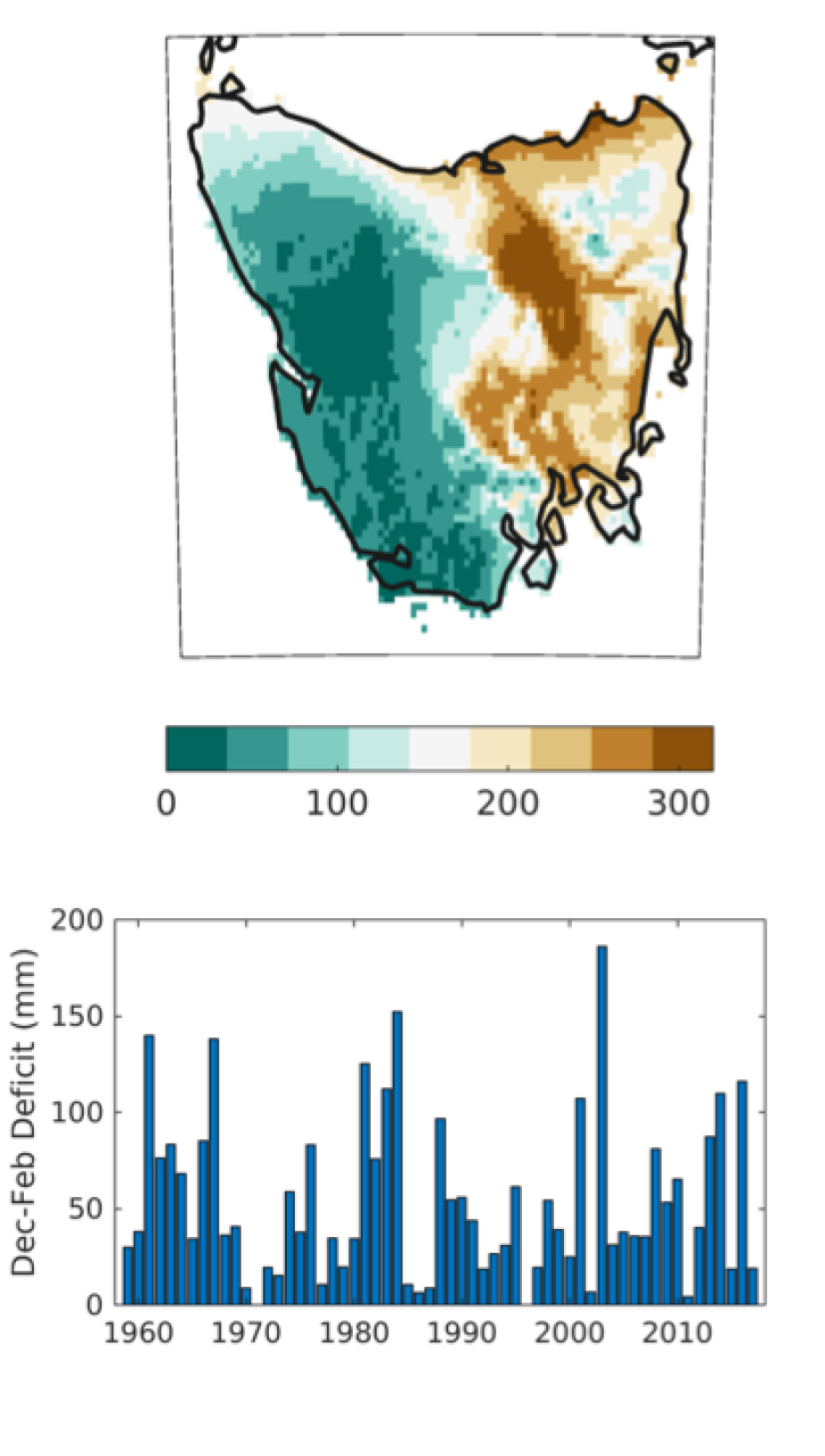
As estimated by TerraClimate: (top) 1981-2010 average Dec-February climatic water deficit for Tasmania (units: mm). (bottom) Time series of DJF climatic water deficit near Mt. Field National Park (42.646S, 146.604E). (contributed by J. Abatzoglou)
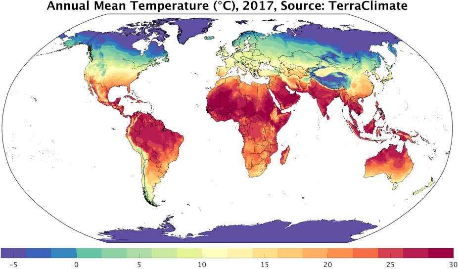
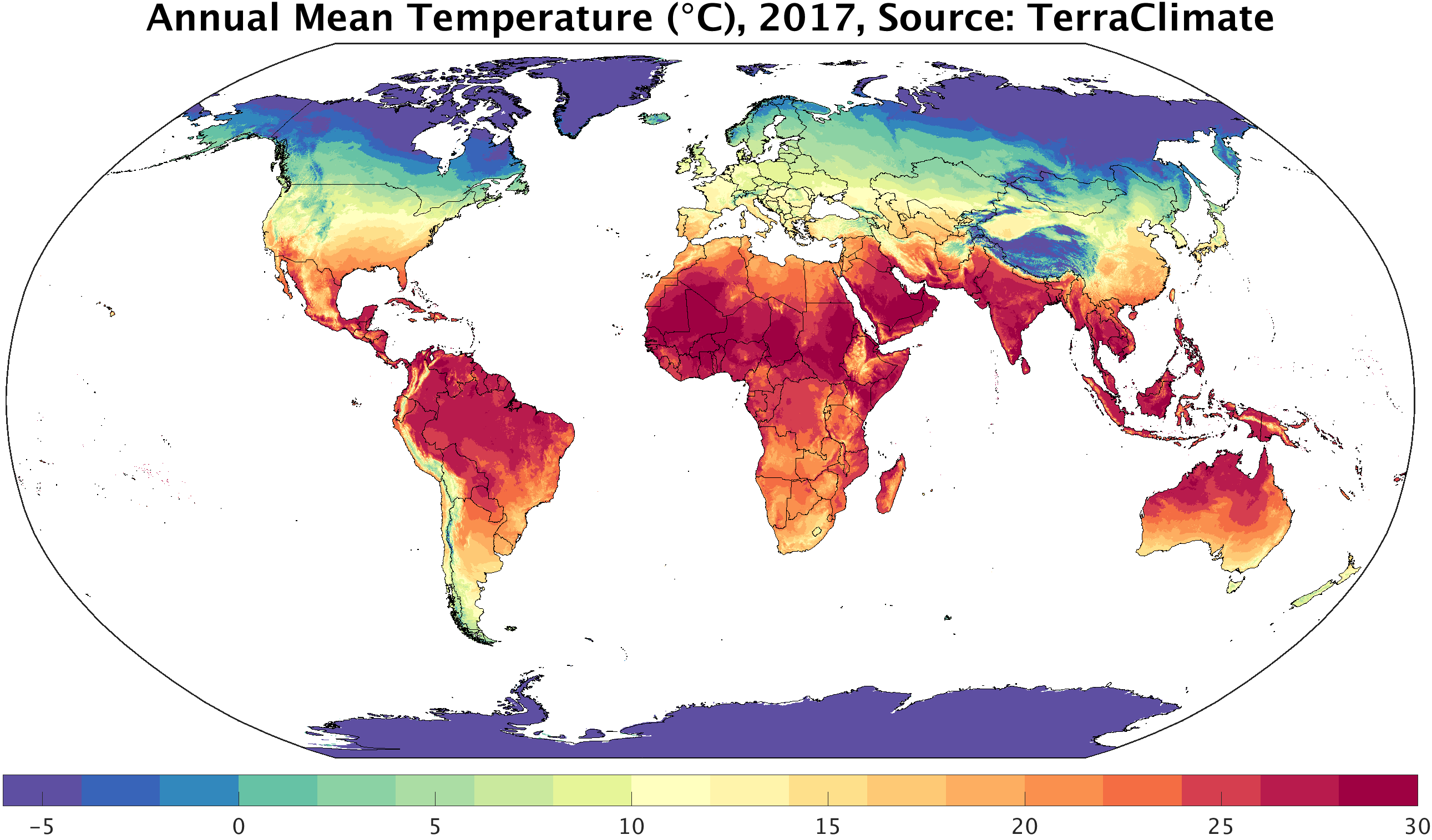
TerraClimate: average annual temperature in 2017. source, https://climate.northwestknowledge.net/TERRACLIMATE/index_animations.php (accessed 14 Dec 2019)
Other Information
- Abatzoglou, J. T., S. Z. Dobrowski, S. A. Parks, and K. C. Hegewisch, 2018: TerraClimate, a high-resolution global dataset of monthly climate and climatic water balance from 1958–2015. Scientific Data, 5.
- Willmott, C. J., C. M. Rowe, and Y. Mintz, 1985: Climatology of the terrestrial seasonal water cycle. Journal of Climatology, 5, 589–606.
- Dobrowski, S. Z., J. Abatzoglou, A. K. Swanson, J. A. Greenberg, A. R. Mynsberge, Z. A. Holden, and M. K. Schwartz, 2012: The climate velocity of the contiguous United States during the 20th century. Global Change Biology, 19, 241–251.
- Wang-Erlandsson, L., and Coauthors, 2016: Global root zone storage capacity from satellite-based evaporation. Hydrology and Earth System Sciences, 20, 1459–1481.