Climate data guide content with tag Precipitation
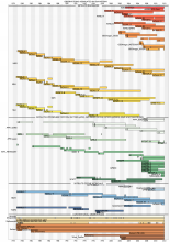
 An overview of paleoclimate information from high-resolution lake sediment records: Strengths, limitations and key databases
Years of record
- N/A
Accumulated sediments at the bottom of lakes are invaluable archives of past climate and environmental change. These sediments contain a variety of physical, geochemical, and biological proxy indicators that can be used to gain a multi-faceted understanding of past conditions. Unlike other high-resolution paleoclimate archives, such as tree rings, corals, and…
Main variables and Earth System components
Atmosphere Air Temperature Precipitation Biosphere Pollen Land-
Formats
- ascii, csv, Linked Paleo Data (LiPD)
-
Timestep
- Annual, Decadal, Irregular
-
Domain
- Global
-
Collections
- N/A
Experts contributing reviews
- Larocca, Laura, Broadman, Ellie
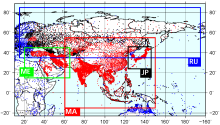 APHRODITE: Asian Precipitation - Highly-Resolved Observational Data Integration Towards Evaluation of Water Resources
Years of record
- to
APHRODITE’s (Asian Precipitation - Highly-Resolved Observational Data Integration Towards Evaluation) gridded precipitation is a set of long-term (1951 onward) continental-scale daily products that is based on a dense network of rain-gauge data for Asia including the Himalayas, South and Southeast Asia and mountainous areas in the Middle East. The gridded products are…
Experts contributing reviews
- Maeda, Mio, Yasutomi, Natsuko, Yatagai, Akiyo
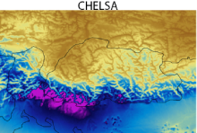 CHELSA high-resolution land surface temperature and precipitation
Years of record
- to
The Climatologies at high resolution for the Earth's land surface (CHELSA) dataset contains high spatial resolution monthly climatologies of mean, maximum and minimum temperatures and mean precipitation, representing the period 1979-2013. CHELSA is essentially a statistical downscaling of the ERA-Interim reanalysis, with the temperature downscaling based on mean…
Experts contributing reviews
- Karger, Dirk
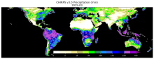
 CHIRPS: Climate Hazards InfraRed Precipitation with Station data (version 2)
Years of record
- to
Note: CHIRPS v2 has been superseded by CHIRPS v3 as of June 2025. Climate Hazards Group InfraRed Precipitation with Station data (CHIRPS) is a quasi-global (50S - 50N), land-only rainfall dataset with a range of temporal and spatial resolutions depending on the region and the time period. Data can be found at 0.05 deg or 0.1 deg resolution, and can be found at 6-hourly…
Experts contributing reviews
- Touma, Danielle, Martinez, Carlos
 CHIRPS: Climate Hazards InfraRed Precipitation with Station data (Version 3)
Years of record
- to
Climate Hazards Group InfraRed Precipitation with Station data version 3 (CHIRPS v3)is a 1981-present, land-only, high resolution 0.05° gridded precipitation dataset. It combines thermal-infrared geostationary satellite-based estimates (CHIRP3), in situ observations from global, regional, and national meteorological networks, and a high-resolution climatology (CHPclim2…
Main variables and Earth System components
Precipitation-
Formats
- GeoTIFF
-
Timestep
- Climatology, Monthly, Annual, Pentad
-
Domain
- Africa, Global, South America
-
Collections
- N/A
Experts contributing reviews
- Alaso, Daniella
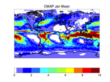 CMAP: CPC Merged Analysis of Precipitation
Years of record
- to
CMAP refers to a collection of precipitation data sets, though the 2.5°x2.5° global monthly version is probably the most widely used. This data set is constructed from an analysis of gauge data and satellite-derived precipitation estimates. An "enhanced" version (CMAP/A) is also available, which provides global coverage by filling in gaps with precipitation forecasts…
-
Timestep
- Monthly, Pentad
-
Domain
- Global
Experts contributing reviews
- Arkin, Phil, Xie, PIngping
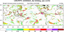 CMORPH (CPC MORPHing technique): High resolution precipitation (60S-60N)
Years of record
- to
"CMORPH (CPC MORPHing technique) produces global precipitation analyses at very high spatial and temporal resolution. This technique uses precipitation estimates that have been derived from low orbiter satellite microwave observations exclusively, and whose features are transported via spatial propagation information that is obtained entirely from geostationary satellite…
Experts contributing reviews
- N/A
 Coral geochemical records: An overview of their use as climate proxies and of available databases
Years of record
- N/A
Coral records are one of the main types of high-resolution (annual to sub-annual) paleoclimate proxies, providing timeseries of environmental conditions reaching hundreds to thousands of years into the past in the tropics, the central driver of the global atmospheric circulation. As such, corals complement paleoclimate records from the largely mid-latitude tree-…
Main variables and Earth System components
Atmosphere Evaporation Evaporation-Precipitation Precipitation Ocean Salinity SST - sea surface temperature-
Formats
- ascii, HTML Table, Linked Paleo Data (LiPD), Matlab
-
Timestep
- N/A
-
Domain
- Atlantic Ocean, Indian Ocean, Pacific Ocean, Tropics
-
Collections
- N/A
Experts contributing reviews
- Lawman, Allison
 COREv2 Air-Sea Surface Fluxes
Years of record
- to
The Coordinated Ocean Research Experiments version 2 (COREv2) data set consists of a globally complete set of air-sea fluxes of momentum, heat and freshwater for 1948-2009 at monthly resolution. This data set serves as a set of common atmospheric boundary conditions that has been used by the ocean modeling community to force and compare a diverse set of…
Main variables and Earth System components
Atmosphere Evaporation Precipitation Radiation Wind Stress Land Runoff and Streamflow Ocean Surface Flux-
Formats
- netCDF
-
Timestep
- Monthly
-
Domain
- Global
-
Collections
- Diagnostic Data Sets, NCAR-DOE-CESM, atmosdiagnostics, oceandiagnostics
Experts contributing reviews
- Yeager, Stephen
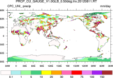 CPC Unified Gauge-Based Analysis of Global Daily Precipitation
Years of record
- to
A gauge-based analysis of daily precipitation has been constructed over the global land areas. Gauge reports from over 30,000 stations are collected from multiple sources including GTS, COOP, and other national and international agencies. Quality control is performed through comparisons with historical records and independent information from measurements at nearby…
Experts contributing reviews
- N/A
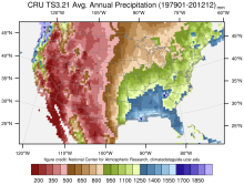 CRU TS Gridded precipitation and other meteorological variables since 1901
Years of record
- to
The CRU TS series of data sets (CRU TS = Climatic Research Unit Time series) contain gridded monthly fields of precipitation, daily maximum and minimum temperatures, cloud cover, and other variables covering Earth's land areas for 1901-2022 (CRU TS4.0 is the recent major release). The data set is gridded to 0.5x0.5 degree resolution, based on analysis of over 4000…
Main variables and Earth System components
Atmosphere Air Temperature Cloud Properties Maximum Air Temperature Minimum Air Temperature Potential Evapotranspiration PrecipitationExperts contributing reviews
- N/A
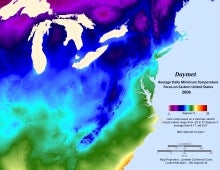 Daymet: Daily Surface Weather and Climatological Summaries
Years of record
- to
Daymet provides long-term, continuous, gridded estimates of daily weather and climatology variables by interpolating and extrapolating ground-based observations through statistical modeling techniques. The Daymet data products provide driver data for biogeochemical terrestrial modeling and have myriad applications in many Earth science, natural resource, biodiversity,…
Main variables and Earth System components
Atmosphere Maximum Air Temperature Minimum Air Temperature Precipitation Radiation Water Vapor Cryosphere Snow Water Equivalent-
Timestep
- Climatology, Daily
-
Domain
- North America
-
Collections
- N/A
Experts contributing reviews
- Thornton, Peter E
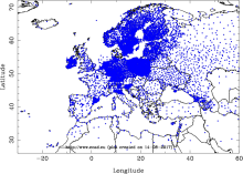 E-OBS: High-resolution gridded mean/max/min temperature, precipitation and sea level pressure for Europe & Northern Africa
Years of record
- to
E-OBS is a high spatial resolution daily gridded data that covers the European region and is based on the station data collated by the ECA&D initiative (Klein Tank et al., 2002). These data are supplied by many European National Meteorological Services and other data providers across Europe and the Middle East. The dataset spans the period 1 January 1950 to the…
Main variables and Earth System components
Atmosphere Air Temperature Maximum Air Temperature Minimum Air Temperature Precipitation Sea Level PressureExperts contributing reviews
- van der Schrier, Gerard
 ERA-Interim
Years of record
- to
Using a much improved atmospheric model and assimilation system from those used in ERA-40, ERA-Interim represents a third generation reanalysis. Several of the inaccuracies exhibited by ERA-40 such as too-strong precipitation over oceans from the early 1990's onwards and a too-strong Brewer-Dobson circulation in the stratosphere, were eliminated or significantly reduced…
Main variables and Earth System components
Atmosphere Air Temperature Geopotential Height Precipitable water Precipitation-
Timestep
- Sub-daily, Daily, Monthly
-
Domain
- Global
Experts contributing reviews
- Dee, Dick
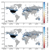 GHCN-D: Global Historical climatology Network daily temperatures
Years of record
- to
The Global Historical Climatology Network Daily database, GHCN-D, contains meteorological measurements from over 90,000 stations across the globe. The majority of station records contain precipitation data only, however other key variables including maximum temperature, minimum temperature, snowfall, cloudiness, wind speed and snow depth are available at many…
Main variables and Earth System components
Atmosphere Maximum Air Temperature Minimum Air Temperature PrecipitationExperts contributing reviews
- McKinnon, Karen
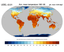 Global (land) precipitation and temperature: Willmott & Matsuura, University of Delaware
Years of record
- to
A series of gridded temperature and precipitation data sets. Station records that served as bases for the Terrestrial Air Temperature: 1900-2014 Gridded Monthly Time Series (Version 4.01) and Terrestrial Precipitation: 1900-2014 Gridded Monthly Time Series (Version 4.01) archives are used here to help create new gridded climatologies of monthly and annual average air…
Main variables and Earth System components
Atmosphere Air Temperature Air Temperature at 2m Precipitation-
Timestep
- Climatology, Monthly
-
Domain
- Global
-
Collections
- Diagnostic Data Sets, NCAR-DOE-CESM, atmosdiagnostics
Experts contributing reviews
- Matsuura, Kenji
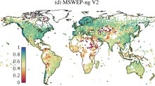 Global high-resolution precipitation: MSWEP
Years of record
- to
Multi-Source Weighted-Ensemble Precipitation (MSWEP) is a sub-daily precipitation dataset with full global coverage at 0.1° resolution, spanning the period 1979 to present. It is updated in near real-time with a latency of three hours, making it suitable for operational applications and for taking a quick look at recent anomalous precipitation events and placing…
Experts contributing reviews
- Beck, Hylke
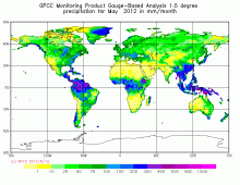 GPCC: Global Precipitation Climatology Centre
Years of record
- to
The GPCC provides gridded gauge-analysis products derived from quality controlled station data. Two products are for climate: (a) the Full Data Reanalysis Product (1901-2010) is recommended for global and regional water balance studies, calibration/validation of remote sensing based rainfall estimations and verification of numerical models, and (b) the VASClimO 50…
-
Timestep
- Climatology, Daily, Monthly
-
Domain
- Global
Experts contributing reviews
- N/A
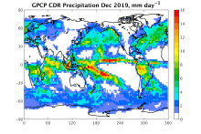
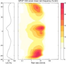 GPCP (Daily): Global Precipitation Climatology Project
Years of record
- to
The 1DD product provides precipitation estimates on a 1-degree grid over the entire globe at 1-day (daily) for the period October 1996 - present. Both the Pentad and 1DD products are consistent with the Version 2 monthly product in the sense that the Pentad and 1DD approximately sum to the monthly SG estimate. All three precipitation products are produced by optimally…
Experts contributing reviews
- Pendergrass, Angeline
 GPCP (Monthly): Global Precipitation Climatology Project
Years of record
- to
Data from rain gauge stations, satellites, and sounding observations have been merged to estimate monthly rainfall on a 2.5-degree global grid from 1979 to the present. The careful combination of satellite-based rainfall estimates provides the most complete analysis of rainfall available to date over the global oceans, and adds necessary spatial detail to the rainfall…
-
Timestep
- Climatology, Monthly
-
Domain
- Global
Experts contributing reviews
- Pendergrass, Angeline, Wang, Jian-Jian
 HadISD: Sub-daily, non-interpolated weather station data
Years of record
- to
HadISD ("Hadley Centre Integrated Surface Database") is a compendium of subdaily weather-station data developed by the UK Met Office that is based on NOAA NCEI's Integrated Surface Database but with various quality-control checks implemented to remove stations with excessive and obvious typographical or instrumental errors, as well as individual occurrences of these…
Main variables and Earth System components
Atmosphere Air Temperature at 2m Dew Point Temperature Precipitation Sea Level Pressure Storm data WindExperts contributing reviews
- Raymond, Colin
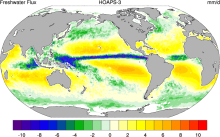 HOAPS: Hamburg Ocean Atmosphere Parameters and Fluxes from Satellite Data
Years of record
- to
The Hamburg Ocean Atmosphere Parameters and Fluxes from Satellite Data (HOAPS) set is a satellite-based climatology of precipitation, evaporation and freshwater budget (evaporation minus precipitation) as well as related turbulent heat fluxes and atmospheric state variables over the global ice free oceans. All variables are derived from SSM/I passive microwave…
Main variables and Earth System components
Atmosphere Evaporation Evaporation-Precipitation Precipitation Radiation Specific Humidity Wind Latent & sensible heat flux Precipitable water Ocean SST - sea surface temperature-
Formats
- netCDF
-
Timestep
- Climatology, Sub-daily, Monthly, Pentad
-
Domain
- Global
-
Collections
- Boundary Conditions
Experts contributing reviews
- N/A
 IMERG precipitation algorithm and the Global Precipitation Measurement (GPM) Mission
Years of record
- to
IMERG (Integrated Multi-satellitE Retrievals for the Global Precipitation Measurement) is NASA's updated precipitation algorithm, while the Global Precipitation Measurement (GPM) mission is an international satellite mission launched by NASA and JAXA on Feb. 27, 2014. The GPM is a follow on to the TRMM satellite mission. NASA have applied the IMERG algorithm to both…
Experts contributing reviews
- Huffman, George J., Tan, Jackson
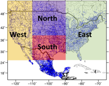 Livneh gridded precipitation and other meteorological variables for continental US, Mexico and southern Canada
Years of record
- to
The Livneh et al. (2015) hydrometeorological dataset consists of gridded daily and monthly precipitation, maximum and minimum air temperature, and wind speed for the continental US, southern Canada, and Mexico for the period 1950-2013. Gridded at 1/16° horizontal resolution (~ 6km), the data have been used as training data for GCM downscaling, as validation for…
Main variables and Earth System components
Atmosphere Maximum Air Temperature Minimum Air Temperature Precipitation Wind-
Formats
- netCDF
-
Timestep
- Daily, Monthly
-
Domain
- North America
-
Collections
- N/A
Experts contributing reviews
- Livneh, Ben
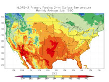 NLDAS: North American Land Data Assimilation System
Years of record
- to
The North American Land Data Assimilation System (NLDAS) integrates a large quantity of observation-based and model reanalysis data to produce long-term hourly atmospheric forcing data, and then uses this meteorological data to drive offline (not coupled to the atmosphere) land-surface and/or hydrological models. The spatial resolution of NLDAS is at 1/8th-degree…
Main variables and Earth System components
Atmosphere Air Temperature CAPE Evaporation Precipitation Radiation Specific Humidity Surface Pressure Wind-
Timestep
- Climatology, Sub-daily, Monthly
-
Domain
- North America
-
Collections
- N/A
Experts contributing reviews
- Xia, Youlong, Mocko, David
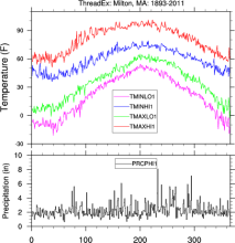 NOAA ThreadEx Long-term Station Extremes for America
Years of record
- to
ThreadEx is a data set of extreme daily temperature and precipitation values for 270 locations in the United States. For each day of the year at each station, ThreadEx provides the top 3 record high and low daily maximum temperatures, the top 3 record high and low daily minimum temperatures, the top 3 daily precipitation totals, along with the years the records were set…
Main variables and Earth System components
Atmosphere Air Temperature Maximum Air Temperature Minimum Air Temperature Precipitation-
Formats
- ascii
-
Timestep
- Daily
-
Domain
- North America
-
Collections
- N/A
Experts contributing reviews
- N/A
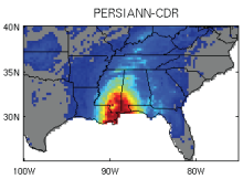 PERSIANN-CDR: Precipitation Estimation from Remotely Sensed Information using Artificial Neural Networks - Climate Data Record
Years of record
- to
The Precipitation Estimation from Remotely Sensed Information using Artificial Neural Networks- Climate Data Record (PERSIANN-CDR) provides daily rainfall estimates at a spatial resolution of 0.25 degrees in the latitude band 60S - 60N from 1983 to the near-present. The precipitation estimate is produced using the PERSIANN algorithm on GridSat-B1 infrared…
-
Timestep
- Sub-daily, Daily
-
Domain
- Global
-
Collections
- Climate Data Record
Experts contributing reviews
- Ashouri, Hamed, Gehne, Maria
 Precipitation Data Sets: Overview & Comparison table
Years of record
- N/A
Precipitation (rain, snow, hail, ...) is one of the key components of the hydrological cycle. Its societal importance cannot be over stated. For climate research, precipitation is one of the key terms for balancing the energy budget, and one of the most challenging aspects of climate modeling. Hence, high quality estimates of precipitation's distribution, amounts and…
-
Formats
- N/A
-
Timestep
- N/A
-
Domain
- N/A
-
Collections
- Overview / Comparison page
Experts contributing reviews
- N/A
 PRISM High-Resolution Spatial Climate Data for the United States: Max/min temp, dewpoint, precipitation
Years of record
- to
PRISM is a set of monthly, yearly, and single-event gridded data products of mean temperature and precipitation, max/min temperatures, and dewpoints, primarily for the United States. In-situ point measurements are ingested into the PRISM (Parameter elevation Regression on Independent Slopes Model) statistical mapping system. The PRISM products use a weighted regression…
Main variables and Earth System components
Atmosphere Dew Point Temperature Maximum Air Temperature Minimum Air Temperature Precipitation-
Formats
- ARC/INFO ASCII GRID, netCDF
-
Timestep
- Climatology, Daily, Monthly
-
Domain
- North America
-
Collections
- N/A
Experts contributing reviews
- Daly, Christopher
 Standardized Precipitation Index (SPI)
Years of record
- to
The Standardized Precipitation Index (SPI) is a widely used index to characterize meteorological drought on a range of timescales. On short timescales, the SPI is closely related to soil moisture, while at longer timescales, the SPI can be related to groundwater and reservoir storage. The SPI can be compared across regions with markedly different climates. It quantifies…
-
Formats
- N/A
-
Timestep
- Monthly
-
Domain
- N/A
-
Collections
- N/A
Experts contributing reviews
- Keyantash, John
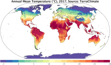 TerraClimate: Global, high-resolution gridded temperature, precipitation, and other water balance variables
Years of record
- to
TerraClimate is a global gridded dataset of meteorological and water balance variables for 1958-present, available on a monthly timestep. Its relatively fine spatial resolution, global extent, and long length are a unique combination that fills a void in climate data. TerraClimate combines spatial climatology from WorldClim with time-varying information from the…
Main variables and Earth System components
Atmosphere Air Temperature Maximum Air Temperature Minimum Air Temperature Potential Evapotranspiration Precipitation Wind Snow Water Equivalent Land evapotranspiration Runoff and Streamflow Soil MoistureExperts contributing reviews
- Abatzoglou, John
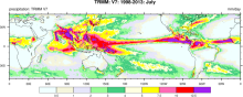 TRMM: Tropical Rainfall Measuring Mission
Years of record
- to
The Tropical Rainfall Measuring Mission (TRMM) is a joint space mission between NASA and Japan's National Space Development Agency designed to monitor and study tropical and subtropical precipitation and the associated release of energy. The mission uses 5 instruments: Precipitation Radar (PR), TRMM Microwave Imager (TMI), Visible Infrared Scanner (VIRS), Clouds &…
-
Timestep
- Sub-daily, Daily, Monthly
-
Domain
- Tropics
-
Collections
- Climate Analysis Section (CAS) Data Catalog, Obs4MIPS
Experts contributing reviews
- Huffman, George J., Pendergrass, Angeline
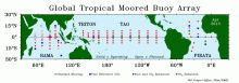 Tropical Moored Buoy System: TAO, TRITON, PIRATA, RAMA (TOGA)
Years of record
- to
The Tropical Ocean Global Atmosphere program (TOGA) is a component of the World Climate Research Programme (WCRP) aimed specifically at the prediction of climate phenomena on time scales of months to years. In order to achieve the TOGA goals, a strategy of large-scale, long-term monitoring of the upper ocean and the atmosphere has been developed. In particular, several…
Main variables and Earth System components
Atmosphere Air Temperature Precipitation Radiation Relative Humidity Sea Level Pressure Wind Ocean Absolute Dynamic Topography (ADT) Ocean Heat Content SST - sea surface temperature Salinity Sub Surface Salinity Sub Surface Temperature u, v current componentsExperts contributing reviews
- N/A
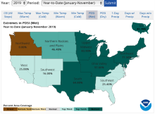 U.S. Climate Extremes Index (CEI)
Years of record
- to
The U.S. Climate Extremes Index (CEI) was first presented in 1995 as a framework for quantifying observed changes in climate within the contiguous United States. At present, the CEI evaluates the percent area of extremes in the distribution of much above/below average (top/bottom 10% of occurrence) temperatures, precipitation, drought, and tropical cyclone wind…
Main variables and Earth System components
Atmosphere Air Temperature Maximum Air Temperature Minimum Air Temperature Precipitation Wind Land Drought-
Formats
- ascii
-
Timestep
- Monthly, Seasonal, Annual
-
Domain
- North America
-
Collections
- N/A
Experts contributing reviews
- Gleason, Karin