Climate data guide content with tag PDSI(PDI)
 Drought atlases from tree rings
Years of record
- to
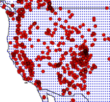
Tree-ring drought atlases provide a paleoclimate analog to modern drought indices, most commonly the Palmer Drought Severity Index (PDSI). Produced on a regular lat-lon grid for regions such as North America, Europe, and Australia, these centuries-long datasets are convenient for comparisons with climate model experiments and historical data on human populations…
-
Timestep
- Annual
-
Domain
- North America
-
Collections
- N/A
Experts contributing reviews
- Cook, Edward
 Palmer Drought Severity Index (PDSI)
Years of record
- N/A
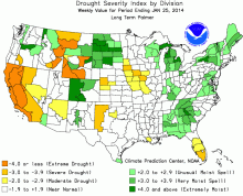
The Palmer Drought Severity Index (PDSI) uses readily available temperature and precipitation data to estimate relative dryness. It is a standardized index that generally spans -10 (dry) to +10 (wet). Maps of operational agencies like NOAA typically show a range of -4 to +4, but more extreme values are possible. The PDSI has been reasonably successful at quantifying…
-
Timestep
- Monthly
-
Domain
- Global
-
Collections
- Climate Analysis Section (CAS) Data Catalog
Experts contributing reviews
- Dai, Aiguo, Bui, Sang, Lenssen, Nathan