Carbon Emissions from Historical Land-Use and Land-Use Change
Annual net land-atmosphere carbon flux and net flux of carbon to the atmosphere due to land-use and land-use change (LULUC) are estimated using an integrated assessment model and three historical reconstructions of land use and land use conversion. The data span 1800-2010 and are aggregated for nine regions of the globe.
Key Strengths
Key Limitations
Expert Developer Guidance
The following was contributed by Prasanth Meiyappan (U Illinois), March, 2013:
The file contains historical estimates (1800-2010) of annual net land-atmosphere carbon flux and net flux of carbon to atmosphere due to land-use and land-use change (LULUC) as calculated using three distinct historical reconstructions of LULUC based on Meiyappan and Jain (2012).
Key Strengths:
1. Carbon estimates using Multiple data sets using a single model, allows to isolate and study LULUC data uncertainty from model related uncertainty.
2. The estimates include the effects of nitrogen cycle, which is relatively new for current generation of land-surface models.
3. This is the first time Houghton's regional data used in book-keeping model is used within a spatially explicit model to estimate carbon emissions (see article for details).
4. The estimates include the combined effect of agricultural expansion (cropland and pastureland), urban land and wood harvest.
Key Limitations:
1. The estimates are obviously subject to model uncertainties. How much the results would differ if the same LULUC data sets are used with a different model is a question to address.
2. It should be noted that while comparing with other studies, uncertainties could also arise due to difference in implementation of same land-use change data in the model apart from uncertainties due to structural differences in model.
2. Several key processes contributing to terrestrial carbon emissions (e.g. peat lands, shifting cultivation) are not included in these estimates, due to lack of data at a global scale.
Research Applications:
1. Primarily for model and data inter-comparison studies. This data forms a integral component in the Carbon Cycle chapter of the upcoming IPCC Fifth Assessment Report.
2. Uncertainty quantification.#
Cite this page
Acknowledgement of any material taken from or knowledge gained from this page is appreciated:
Meiyappan, Prasanth & National Center for Atmospheric Research Staff (Eds). Last modified "The Climate Data Guide: Carbon Emissions from Historical Land-Use and Land-Use Change .” Retrieved from https://climatedataguide.ucar.edu/climate-data/carbon-emissions-historical-land-use-and-land-use-change on 2026-02-24.
Citation of datasets is separate and should be done according to the data providers' instructions. If known to us, data citation instructions are given in the Data Access section, above.
Acknowledgement of the Climate Data Guide project is also appreciated:
Schneider, D. P., C. Deser, J. Fasullo, and K. E. Trenberth, 2013: Climate Data Guide Spurs Discovery and Understanding. Eos Trans. AGU, 94, 121–122, https://doi.org/10.1002/2013eo130001
Key Figures
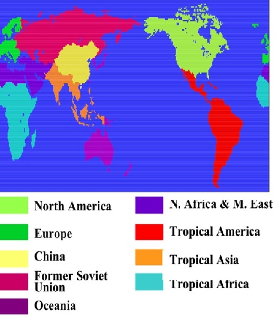
The emission estimates are provided for 9 regions covering the entire globe. Contributed by P. Meiyappan.

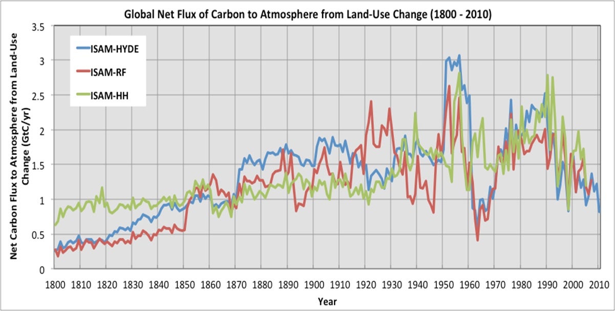
ISAM estimated global land-use emissions for the period 1900-2010 (GtC/yr) based on ISAM-HYDE, ISAM-RF and ISAM-HH data sets. Contributed by P. Meiyappan.
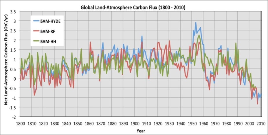
ISAM estimated net land-atmosphere carbon flux for the period 1900-2010 (GtC/yr) based on ISAM-HYDE, ISAM-RF and ISAM-HH data sets. Contributed by P. Meiyappan.
Other Information
- Jain, A.K., Meiyappan, P., Song, Y., and House, J. I. (2013), 'CO2 Emissions from Land-Use Change Affected More by Nitrogen Cycle, than by the Choice of Land Cover Data', Global Change Biology
- Meiyappan and Jain (2012), Three distinct estimates of historical land-cover change and land-use conversions for over 200 years, Frontiers of Earth Science, 6(2), 122-139