An overview of paleoclimate information from high-resolution lake sediment records: Strengths, limitations and key databases
Accumulated sediments at the bottom of lakes are invaluable archives of past climate and environmental change. These sediments contain a variety of physical, geochemical, and biological proxy indicators that can be used to gain a multi-faceted understanding of past conditions. Unlike other high-resolution paleoclimate archives, such as tree rings, corals, and speleothems, lake sediments generally offer continuous records of environmental change over thousands of years or longer. Although lakes are complex environmental systems and lake sediment proxies can be challenging to interpret, lake-derived proxies have provided critical context in regions like the Arctic where instrumental observations are sparse and short in duration (e.g. Kaufman et al., 2009).
Key Strengths
Lake sediments generally offer continuous records of climate and environmental change over thousands of years or longer
Lake sediment archives preserve numerous physical, geochemical, and biological components that when measured can be used as a substitute, or proxy for specific past conditions. Thus, several proxies are often available for analysis within a single record.
Lakes are abundant and distributed worldwide, meaning that these sedimentary archives offer a broad geographic coverage, encompassing diverse climatic zones and environmental settings.
Key Limitations
Though lake sediment records cover wide spatial and temporal ranges, available records are concentrated in the Northern Hemisphere and mostly cover only the Holocene, with fewer records of very old and very recent time periods
The temporal resolution of a lake sediment record depends on the lake’s sedimentation rate, the availability of the proxy indicator, and the dating techniques applied. Truly annually resolved or varved lake sediment records are rare.
As lakes are complex systems that are sensitive to both local and regional changes, interpreting lake sediment proxies requires a thorough understanding of the relationships between climate and environmental variables and a given proxy’s response.
- Temperature 12K database, including about 715 records from lake sediments in LiPD format
- NOAA NCEI Paleo Data Search with about 723 studies from lake sediments
- LegacyClimate pollen-based climate reconstructions
- Neotoma Paleoecology database, covering the Pliocene and Quaternary periods
- Past Global Changes (PAGES) 2K Network of temperature-sensitive proxy records for the Common Era
- Iso2K global database of paleo-δ18O and δD records for the Common Era.
- Database of western North American Holocene paleoclimate records (Rouston et al., 2021)
Expert User Guidance
The following was contributed by Ellie Broadman and Laura Larocca, May, 2023:
General overview and key databases
Accumulated sediments at the bottom of lakes are invaluable archives of past climate and environmental change. These sediments contain a variety of physical, geochemical, and biological proxy indicators (Table 1) that can be used to gain a multi-faceted understanding of past conditions.
NOAA’s National Centers for Environmental Information (NCEI) manages a large archive of paleoclimate proxy data and reconstructions, including from lake sediments. The Paleo Data Search allows users to search all available datasets from NCEI and the World Data Service for Paleoclimatology by data type, investigator, location, time period, and other variables. Of the over 10,000 datasets, 723 studies from lake sediments (“paleolimnology”) are available.
The Temperature 12K database is a global collection of Holocene paleotemperature records available in Linked Paleo Data (LiPD) format. The included proxy records have a demonstrated relationship with temperature and are quality-controlled (e.g., have a minimum duration, resolution, and chronological accuracy). The compilation includes 1319 paleotemperature records, including ~715 records from lake sediments (Kaufman et., al 2020).
Covering the Pliocene and Quaternary, the Neotoma Paleoecology database is a global, community-curated repository for paleoecological and paleoenvironmental data, including pollen, a proxy commonly used in data-model comparisons. For the Holocene, LegacyClimate provides the most complete dataset of pollen-based paleoclimate reconstructions (Herzschuh et al., 2022).
Other relevant databases include:
● The database of western North American Holocene paleoclimate records comprises reconstructions of temperature, hydroclimate, and circulation changes, including 259 records from lakes (Routson et al., 2021).
● The Past Global Changes (PAGES) 2K Network is a community-sourced database of temperature-sensitive proxy records for the Common Era (PAGES2k Consortium, 2017).
● Iso2K is a global database of paleo-δ18O and δD records for the Common Era. Iso2k plays a role in isotope-enabled models, circumventing some issues related to converting proxy values to standard climate variables.
What are the key strengths of this data set?
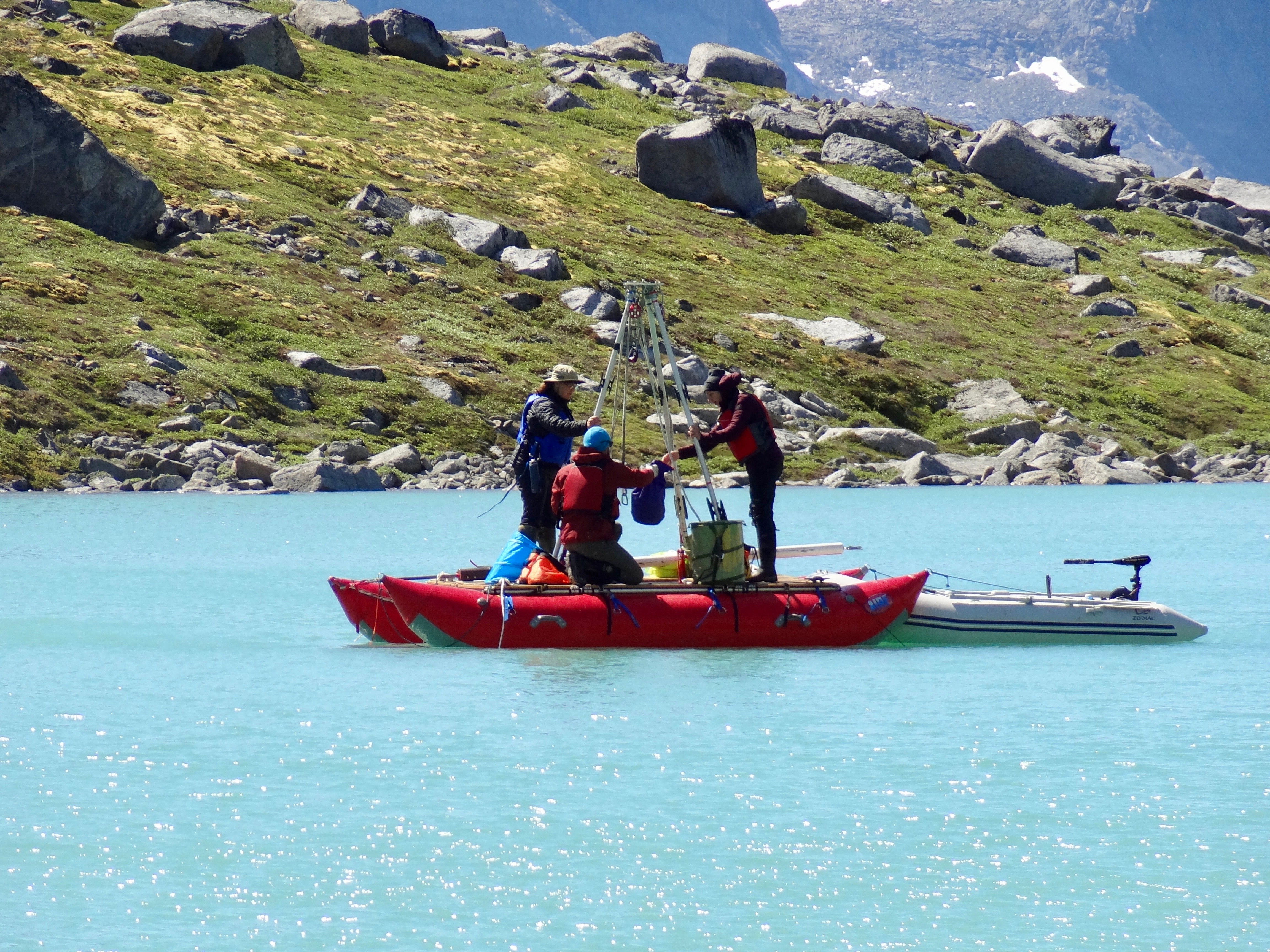
As opposed to other high resolution paleoclimate archives, such as tree rings, corals, and speleothems, lake sediments generally offer continuous records of climate and environmental change over thousands of years or longer. For example, many lakes in the northern mid-to-high latitudes formed when ice sheets receded after the last glacial period, and contain sediments deposited throughout most or all of the Holocene epoch. Some lake sediment records extend back even farther in time, and record past conditions over millions of years (e.g., Lake Baikal; Williams et al., 2007). The temporal resolution of lake sediments is often higher than that of other sedimentary records, such as ocean sediments, due to higher deposition rates in most terrestrial environments – typically, a centimeter of lake sediment contains less than a decade to several centuries of information. Although less abundant, some lake sediments are varved, or annually laminated. Varves form in deep lakes with minimal disturbance to the sediment-water interface and seasonal processes that form distinct layers (Zolitschka et al., 2014). In some cases, sub-annual resolution in varved sediments can allow for analysis of extreme events, such as turbidites from earthquakes or anomalous layers from large floods, as well as short-term climate variability.
Lake sediment archives preserve numerous physical, geochemical, and biological (e.g., Battarbee et al., 2000) components that when measured can be used as a substitute, or proxy for specific past conditions (Table 1). Thus, as several proxies are often available for analysis within a single record, lake sediment archives offer a unique, multi-proxy potential. This means that researchers can qualitatively or quantitatively reconstruct various climate and environmental variables and explore several different facets of past change at a single site. In addition, a variety of geochronological tools can be applied to lake sediments to robustly constrain sediment age, including: radiocarbon (14C), Lead-210/Cesium-137, tephrochronology, paleomagnetic secular variation, and optically stimulated luminescence.
Finally, lakes are abundant and distributed worldwide, meaning that these sedimentary archives offer a broad geographic coverage, encompassing diverse climatic zones and environmental settings (Figure 1). The global network of lake sediment records, though biased toward the Northern Hemisphere, allows for reconstruction of local, regional, and global climate patterns, which in turn allow for assessments of the spatial variability of past environmental changes.
What are the key limitations of this data set?
Though lake sediment records cover wide spatial and temporal ranges, they are concentrated in the Northern Hemisphere (Figure 1), and most cover only the Holocene, with fewer records of very recent and very old time periods. Recent, surficial lake sediments are difficult to capture intact, and can be influenced by human activities, complicating, or compromising our ability to interpret the environmental signal they contain. The availability of continuous lake sediment records over long timescales (hundreds of thousands to millions of years) is also limited because there are many physical and biological processes that can disrupt, alter, or remove deposited sediments.
The temporal resolution of a lake sediment record depends on the lake’s sedimentation rate, the availability of the proxy indicator, and the dating techniques applied (Figures 1 and 2). Unless sediments are varved, multiple years, decades, or centuries of information are averaged in each centimeter of sediment, which can make it difficult to definitively establish relationships between instrumental climate data and proxy data. In addition, the modeling methods used to establish age-depth relationships in the sediment column are inherently uncertain and depend on the number of age determinations provided and the dating method applied (Figure 2).
Lakes are complex systems that are sensitive to both local and regional changes. Interpreting lake sediment proxies requires a thorough understanding of the relationships between climate and environmental variables and a given proxy’s response. Moreover, most proxy indicators are influenced by multiple climatic and environmental factors and can be biased toward a particular season (often the growing season, or summer). Disentangling these influences and attributing changes solely to a specific climate variable can be difficult. A multi-site and multi-proxy approach is often helpful.
What are some common mistakes that users encounter when processing or interpreting these data?
All methods used to measure or estimate the ages of lake sediments come with a degree of uncertainty. This uncertainty can be misunderstood, underestimated, or inadequately represented in data analysis and visualization. Analytical and sampling errors can also contribute to age-depth uncertainties. As most paleolimnological studies use radiocarbon, the 14C system must be thoroughly understood (e.g., calibration curves, reservoir effects, selection of datable material).
Paleoenvironmental inferences based on lake sediments can also be confounded by misinterpretation or simplified interpretation of proxy data. An insufficient understanding of the relationship between the proxy response to an environmental change can lead to spurious conclusions. A multi-faceted, multi-proxy perspective can be especially useful for disentangling local or site-specific environmental changes (e.g., a local mass wasting event causing increased clastic material deposition) from more regional or synoptic changes in climate (e.g., higher regional precipitation causing increased deposition of clastic material).
What are the likely spurious (non-climatic) features, if any, of timeseries derived from these data?
Lakes are sensitive and respond to changes that occur in and around their watersheds, which include both environmental and non-climatic factors. For example, non-climatic geomorphological or tectonic processes, post-depositional processes that disturb sediments, and human activities may cause changes in sediment composition, accumulation rate, or in various sedimentary properties. For example, vertical mixing at the sediment-water interface via bioturbation and other disturbances can disrupt the original sediment layers and can cause time-averaging or smoothing of the environmental signal. In addition, poor preservation or degradation of certain biological proxies can be mistaken for a lack of presence of a given taxa driven by a change in climate.
Describe any conversion steps that are necessary or general strategies to compare these data with model output.
Lake sediment proxy data must be calibrated or converted to a climate variable of interest (e.g., temperature, precipitation) for meaningful comparison with climate model output. “Calibration in time” approaches use statistical methods to determine a relationship between the proxy value and climate variable using instrumental or observational data from the modern period, while “calibration in space” approaches relate proxy data to modern data over environmental gradients (e.g., Mederios et al., 2022). However, surprisingly few proxy datasets are converted to quantitative climate variables. Data compilations that have harmonized site-level entries and apply uniform procedures for converting to climate variables may be especially useful in data-model comparisons. In these compilations, smoothing (reduced variance) can occur from averaging together age-uncertain time series. Some other commonly reconstructed variables, like lake level, are strongly related to physical climate, and are frequently used for comparison with climate models (e.g., Street-Perrot et al., 1989). Another increasingly popular approach is to use proxy system models to forward model the processes by which climate data become recorded in lake sediment proxies, making comparison between data and models more direct (e.g., Dee et al., 2018).
Model data are often very high resolution (e.g., daily, seasonal, annual), whereas lake sediment data are lower resolution (e.g., annual, decadal, centennial) with chronological uncertainties. Therefore, lake sediment proxy and model data must be temporally aligned for comparison. Likewise, proxy-model comparisons must be made on comparable spatial scales. Issues may arise if lake sediment proxy records, representative of localized or regional signals, are compared with larger scale model grid points. Model downscaling or other upscaling techniques (e.g., via proxy composites) can be used to better compare proxy data with model output. In other instances, model simulations of past climate are presented as time slices, including through the Paleoclimate Modeling Intercomparison Project (PMIP). These slices provide information at varying resolution, so sedimentary data must be time-adjusted accordingly for comparison.
Provide a summary statement about these data and their utility for climate research and model evaluation.
Lake sediment data provide valuable insights into past climate and environmental conditions, making them useful for climate research and model evaluation. Importantly, these data extend climate records beyond the limited temporal range of instrumental measurements. As such, they provide a valuable understanding of natural climate variability, and an expanded temporal context to evaluate the rate, magnitude, and impacts of modern global warming. More broadly, paleoclimate data (including lake sediment records) provide a means for assessing the performance of climate models in simulating past climate conditions, offering opportunities to improve the representation of the climate system in model simulations of future conditions.
Cite this page
Acknowledgement of any material taken from or knowledge gained from this page is appreciated:
Larocca, Laura &, Broadman, Ellie & National Center for Atmospheric Research Staff (Eds). Last modified "The Climate Data Guide: An overview of paleoclimate information from high-resolution lake sediment records: Strengths, limitations and key databases.” Retrieved from https://climatedataguide.ucar.edu/climate-data/overview-paleoclimate-information-high-resolution-lake-sediment-records-strengths on 2026-07-07.
Citation of datasets is separate and should be done according to the data providers' instructions. If known to us, data citation instructions are given in the Data Access section, above.
Acknowledgement of the Climate Data Guide project is also appreciated:
Schneider, D. P., C. Deser, J. Fasullo, and K. E. Trenberth, 2013: Climate Data Guide Spurs Discovery and Understanding. Eos Trans. AGU, 94, 121–122, https://doi.org/10.1002/2013eo130001
Key Figures
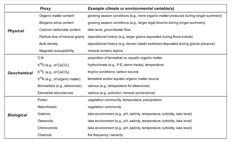
Table 1. Common physical, geochemical, and biological lake sediment proxy types (lists are not comprehensive) that can be recovered from lake sediment archives and analyzed to infer information about past climate and environmental conditions.
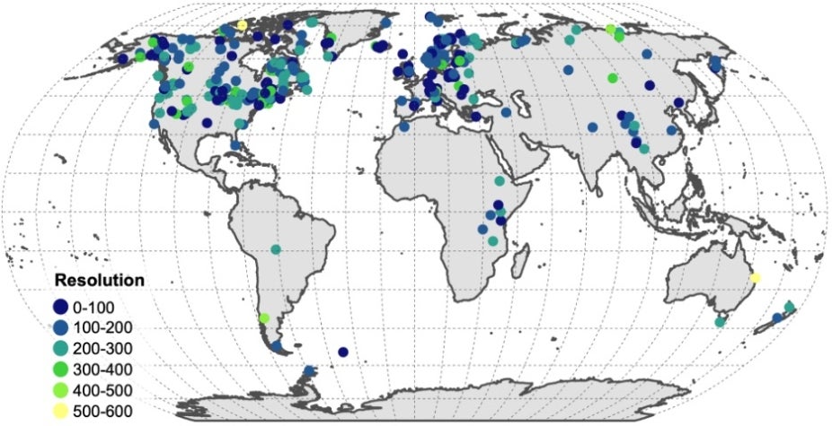
Figure 1. Global distribution of lake sediment records in the Temperature 12K database (n=715). Site locations are colored by the resolution of the timeseries (i.e., the median spacing in years between samples over the full record length; Kaufman et al. 2020). contributed by Ellie Broadman and Laura Larocca
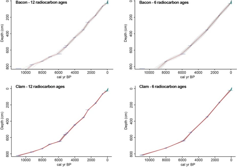
Figure 2. Four different age-depth models for the same sediment core, from Kelly Lake in the Kenai Peninsula lowlands, Alaska (Broadman et al., 2022). Radiocarbon ages are shown in blue symbols, whereas green symbols in the surface sediments are ages from the Pb-210 model. In the left column, the age-depth models use all available 12 radiocarbon ages. In the right column, they use only six. The top row uses “Bacon'' age-depth modeling (R package “rbacon” v. 3.1; Blaauw and Christen, 2011), and the bottom row uses “Clam” (R package “clam” v. 2.5; Blaauw, 2010). All age models were run with default settings. Red lines indicate the median (for Bacon) or weighted average (for Clam) of all iterations produced in the age modeling process, and gray lines or envelopes show upper and lower 95% confidence intervals. Contributed by Ellie Boardman and Laura Larocca.
Other Information
- Battarbee, Richard W. "Palaeolimnological approaches to climate change, with special regard to the biological record." Quaternary science reviews 19.1-5 (2000): 107-124.
- Blaauw, Maarten. "Methods and code for ‘classical’ age-modelling of radiocarbon sequences." Quaternary geochronology 5.5 (2010): 512-518.
- Blaauw, Maarten, and J. Andrés Christen. "Flexible paleoclimate age-depth models using an autoregressive gamma process." Bayesian Anal. 6(3) (2011): 457-474.
- Broadman, Ellie, et al. "Reconstructing postglacial hydrologic and environmental change in the eastern Kenai Peninsula lowlands using proxy data and mass balance modeling." Quaternary Research 107 (2022): 1-26.
- Dee, Sylvia G., et al. "PRYSM v2. 0: A proxy system model for lacustrine archives." Paleoceanography and Paleoclimatology 33.11 (2018): 1250-1269.
- Herzschuh, Ulrike, et al. "LegacyClimate 1.0: A dataset of pollen-based climate reconstructions from 2594 Northern Hemisphere sites covering the late Quaternary." Earth System Science Data Discussions (2022): 1-29.
- Kaufman, D. S., and Coauthors, 2009: Recent Warming Reverses Long-Term Arctic Cooling. Science, 325, 1236–1239, https://doi.org/10.1126/science.1173983.
- Kaufman, Darrell, et al. "A global database of Holocene paleotemperature records." Scientific data 7.1 (2020): 115.
- Medeiros, Andrew S., et al. "A continental-scale chironomid training set for reconstructing Arctic temperatures." Quaternary Science Reviews 294 (2022): 107728.
- PAGES2k Consortium. "A global multiproxy database for temperature reconstructions of the Common Era." Scientific data 4 (2017).
- Routson, Cody C., et al. "A multiproxy database of western North American Holocene paleoclimate records." Earth System Science Data 13.4 (2021): 1613-1632.
- Street-Perrott, F. A., et al. Global lake-level variations from 18,000 to 0 years ago: A palaeoclimate analysis. No. DOE/ER/60304-H1. Oxford Univ.(UK). Geography School, 1989.
- Williams, D. F., et al. "Lake Baikal record of continental climate response to orbital insolation during the past 5 million years." Science 278.5340 (1997): 1114-1117.
- Zolitschka, Bernd, et al. "Varves in lake sediments–a review." Quaternary Science Reviews 117 (2015): 1-41.