Sea Ice Concentration data from NOAA OI

Teaser image
Sea Ice Concentration data from NOAA OI
Main content

The NOAA Optimal Interpolation (OI) v2 sea ice data set contains gridded, weekly or monthly resolution sea ice concentration estimates for both the Northern and Southern Hemispheres. It is intended as a consistent analyses for input into SST analyses (and is the basis for calculating SSTs in sea ice zones for the OI SST data) or as boundary conditions for atmospheric models. The sea ice portion of NOAA OI v2 is produced similarly to HadISST sea ice, using adjusted passive microwave derived sea ice data from from the NASA Goddard NASA Team algorithm followed by operational sea ice data from NCEP. Users should be aware that the NOAA OI sea ice contains similar discontinuities as HadISST in recent years (see Screen, 2011).

Key Strengths

Key Strengths

Gridded, long-term weekly or monthly data set convenient for modeling or analyses

Regularly updated

Key Limitations

Key Limitations

Higher resolution and more homogenous (single algorithm) data are available for the modern satellite period, 1979-present.

Similar to HadISST through ~1996; post 1996 no adjustments were made to account for changing satellite sources and/or algorithms employed by NCEP; switches made in 1997, 2004, 2006, 2009 and 2011 may strongly affect the timeseries

Please cite data sources, following the data providers' instructions
Suggested Data Citation
  1. from NOAA ESRL: NOAA_OI_SST_V2 data provided by the NOAA/OAR/ESRL PSD, Boulder, Colorado, USA, from their Web site at http://www.esrl.noaa.gov/psd/

Dataset DOIs
None
Hosted Climate Index Files
None
Usage Restrictions
None

Cite this page

Acknowledgement of any material taken from or knowledge gained from this page is appreciated:

National Center for Atmospheric Research Staff (Eds). Last modified "The Climate Data Guide: Sea Ice Concentration data from NOAA OI.” Retrieved from https://climatedataguide.ucar.edu/climate-data/sea-ice-concentration-data-noaa-oi on 2024-03-29.


Citation of datasets is separate and should be done according to the data providers' instructions. If known to us, data citation instructions are given in the Data Access section, above.


Acknowledgement of the Climate Data Guide project is also appreciated:

Schneider, D. P., C. Deser, J. Fasullo, and K. E. Trenberth, 2013: Climate Data Guide Spurs Discovery and Understanding. Eos Trans. AGU, 94, 121–122, https://doi.org/10.1002/2013eo130001

Key Figures

Arctic sea ice: NOAA OI

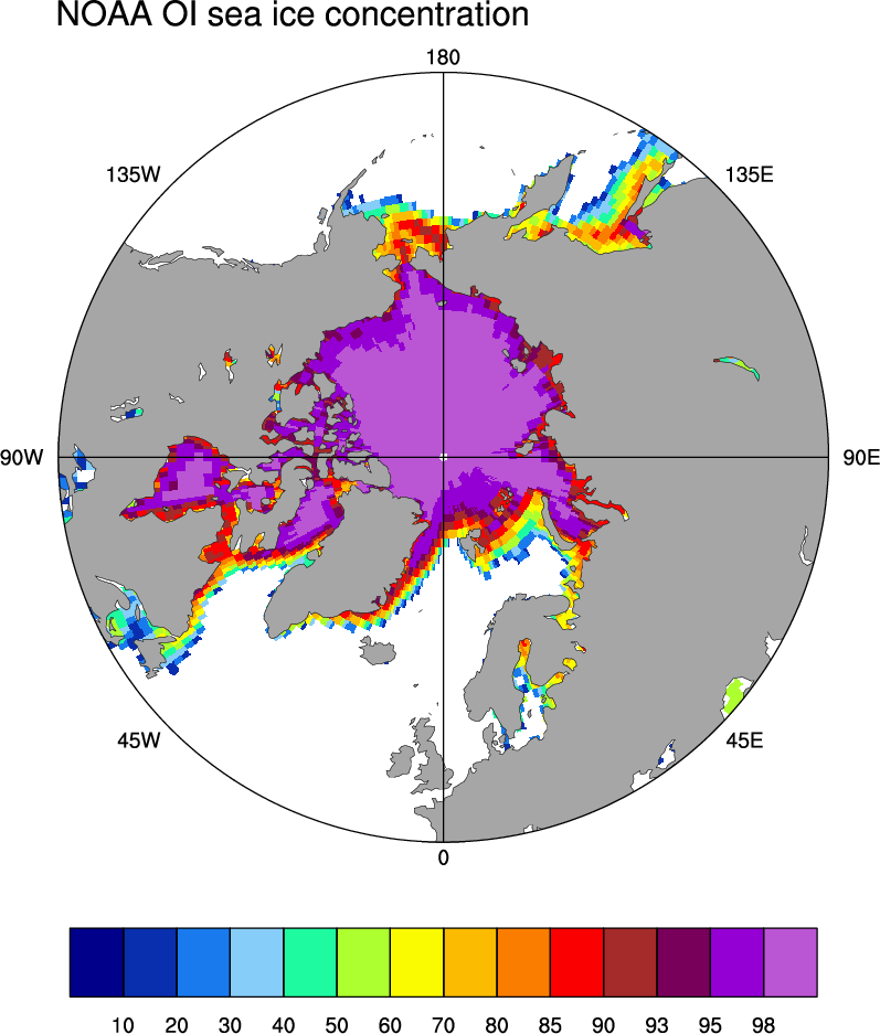
Average Arctic sea ice concentration for March 2003-2007 from the NOAA OI data set. (Figure by D. Schneider, NCAR).

Other Information

Earth system components and main variables
Dataset collections

Years of record
to
Data time period extended
Yes, data set is extended
Timestep
Monthly, Weekly
Formats:
Input Data

adjusted passive microwave -derived sea ice from NASA Goddard and NCEP operations

Vertical Levels:
Missing Data Flag
Missing data present
Ocean or Land
Ocean Only
Spatial Resolution

1° x 1°

Model Resolution (reanalysis)
None
Data Assimilation Method
None
Model Vintage (reanalysis)
None

Key Publications
Not available...