Climate data guide content with tag AIRS
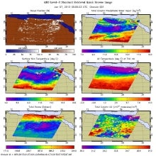 AIRS (Atmospheric InfraRed Sounder): Version 6 Level 2
Years of record
- to
AIRS Version 6 Level 2 data represent a significant improvement over AIRS Version 5 Level 2 products in terms of greater stability, yield, and quality. Several algorithmic improvements have been made by the AIRS Project in conjunction with the AIRS Science Team. Improvements include: (a) Improved soundings of Tropospheric and Sea Surface Temperatures, day and night…
Main variables and Earth System components
Atmosphere Aerosols Air Temperature CO Geopotential Height Ozone: Tropospheric Precipitable water Specific HumidityExperts contributing reviews
- N/A
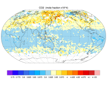 AIRS and AMSU: Trace Gases (CO2, CO, CH4, O3...); Level 3
Years of record
- N/A
AIRS provides satellite retrieval of mid-tropospheric carbon dioxide even under cloudy conditions, without the use of a priori information from models. AIRS retrievals use cloud-cleared thermal IR radiance spectra in the 15 micron band with an accuracy better than 2 ppm. AIRS retrievals have been used to produce global maps of carbon dioxide and other trace gases…
Main variables and Earth System components
Atmosphere CO Ozone: Tropospheric Biosphere CH4-Methane CO CO2-
Timestep
- Sub-daily, Daily, Monthly
-
Domain
- Global
-
Collections
- Carbon cycle
Experts contributing reviews
- N/A
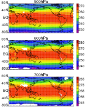 AIRS and AMSU: Tropospheric air temperature and specific humidity
Years of record
- to
The Atmospheric Infrared Sounder (AIRS) project has generated decadal-length, global, gridded data sets of temperature and specific humidity for several standard levels in the troposphere for the obs4MIPS project. This obs4MIPS version of the AIRS data are available at monthly resolution, 1ºx1º grids and formatted to facilitate easier comparisons with CMIP5 model output…
Experts contributing reviews
- Tian, Baijun
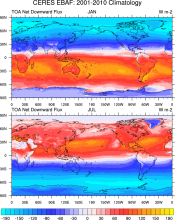 CERES EBAF: Clouds and Earth's Radiant Energy Systems (CERES) Energy Balanced and Filled (EBAF)
Years of record
- to
The CERES-EBAF product provides 1-degree regional, zonal and global monthly mean Top-of-Atmosphere (TOA) and surface (SFC) longwave (LW), shortwave (SW), and net (NET) fluxes under clear and all-sky conditions. EBAF is used for climate model evaluation, estimating the Earth's global mean energy budget, and to infer meridional heat transport. The data synthesized to…
Experts contributing reviews
- Loeb, Norman