CERES: IGBP Land Classification

The International Geosphere–Biosphere Programme (IGBP) defines ecosystems surface classifications. The CERES (Clouds and Earth's Radiant Energy System)10-minute data can be used to derive the land categories.
Cite this page
Acknowledgement of any material taken from or knowledge gained from this page is appreciated:
National Center for Atmospheric Research Staff (Eds). Last modified "The Climate Data Guide: CERES: IGBP Land Classification.” Retrieved from https://climatedataguide.ucar.edu/climate-data/ceres-igbp-land-classification on 2026-07-14.
Citation of datasets is separate and should be done according to the data providers' instructions. If known to us, data citation instructions are given in the Data Access section, above.
Acknowledgement of the Climate Data Guide project is also appreciated:
Schneider, D. P., C. Deser, J. Fasullo, and K. E. Trenberth, 2013: Climate Data Guide Spurs Discovery and Understanding. Eos Trans. AGU, 94, 121–122, https://doi.org/10.1002/2013eo130001
Key Figures
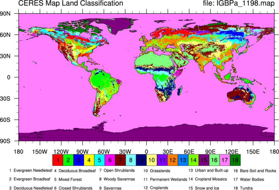
CERES land classification from IGBPa_1198.map.nc. Surface types 1 - 17 correspond to those defined by IGBP (International Geosphere Biosphere Programme). The last 3 surface types were defined for CERES. Surface type 18, Tundra; Fresh snow, number 19, and sea ice, number 20 are not permanent surface types. They are obtained daily from the National Snow and Ice Data Center. The IGBP surface type for snow and ice number 15, is for permanent snow and ice. (Climate Data Guide; D. Shea)

Land-sea mask ( IGBPa_1198.map ). [Climate Data Guide; D. Shea]
Other Information
- IGBP, 1990, The International Geosphere–Biosphere Programme: a study of global change— the initial core project. IGBP Global Change Report no. 12, International Geosphere–Biosphere Programme, Stockholm, Sweden.
- IGBP, 1992, Improved Global Data for Land Applications, edited by J. R. G. Townshend. IGBP Global Change Report no. 20, International Geosphere–Biosphere Programme, Stockholm, Sweden.
- Wickland, Diane E. 1991. Mission to Planet Earth: The Ecological Perspective. Ecology 72:1923–1933