Climate data guide content with tag Dew Point Temperature
 HadISD: Sub-daily, non-interpolated weather station data
Years of record
- to
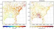
HadISD ("Hadley Centre Integrated Surface Database") is a compendium of subdaily weather-station data developed by the UK Met Office that is based on NOAA NCEI's Integrated Surface Database but with various quality-control checks implemented to remove stations with excessive and obvious typographical or instrumental errors, as well as individual occurrences of these…
Main variables and Earth System components
Atmosphere Air Temperature at 2m Dew Point Temperature Precipitation Sea Level Pressure Storm data WindExperts contributing reviews
- Raymond, Colin
 Integrated Global Radiosonde Archive (IGRA)
Years of record
- to
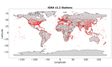
The largest publicly available collection of quality-controlled, globally-distributed, historical radiosonde and pilot balloon observations is the Integrated Global Radiosonde Archive (IGRA; Durre et al. 2006, 2018). First released in 2004, IGRA is maintained and distributed by NOAA’s National Centers for Environmental Information (NCEI). IGRA v2.2, which was released…
Main variables and Earth System components
Atmosphere Dew Point Temperature Geopotential Height Multiple variables Relative Humidity WindExperts contributing reviews
- Durre, Imke, Korzeniewski, Bryant
 PRISM High-Resolution Spatial Climate Data for the United States: Max/min temp, dewpoint, precipitation
Years of record
- to
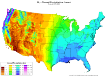
PRISM is a set of monthly, yearly, and single-event gridded data products of mean temperature and precipitation, max/min temperatures, and dewpoints, primarily for the United States. In-situ point measurements are ingested into the PRISM (Parameter elevation Regression on Independent Slopes Model) statistical mapping system. The PRISM products use a weighted regression…
Main variables and Earth System components
Atmosphere Dew Point Temperature Maximum Air Temperature Minimum Air Temperature Precipitation-
Formats
- ARC/INFO ASCII GRID, netCDF
-
Timestep
- Climatology, Daily, Monthly
-
Domain
- North America
-
Collections
- N/A
Experts contributing reviews
- Daly, Christopher