Overview: Climate Indices
A climate index is a simple diagnostic quantity that is used to characterize an aspect of a geophysical system such as a circulation pattern. A variety of methods have been used to derive assorted indices. Classically, selected station, grid point or regional average data have been used (eg., Southern Oscillation Index, Nino 3.4). Other indices are based upon empirical orthogonal functions (EOFs; eg., Artic Oscillation, North Atlantic Oscillation (NAO), Northern Annular Mode, (NAM)) or a rotated EOF (REOF; eg, Pacific-North American). Most indices use a single variable (eg., sea level pressure, sea surface temperature anomalies, geopotential height, precipitation) while others, such as the Palmer Drought Index (PDI) use a combination of variables (eg, temperature and precipitation). Most commonly, anomalies from an arbitrarily defined base period (eg; 1950-79) are the values used. Unfortunately, some indices are known by several names: eg, the Southern Annular Mode (SAM) is also known as the Antarctic Oscillation (AAO). Also, some indices have minor controversial issues. For example, the physical distinction from NAO and North Pacific indices is not completely agreed upon by researchers. These issues can result in user confusion. Further, use of different source data sets, different base periods and, where applicable, different normalizations can yield different index values.
A number of websites provide excellent descriptions of one or more of the climate indices. In addition, some provide index data.
Key Strengths
Key Limitations
Cite this page
Acknowledgement of any material taken from or knowledge gained from this page is appreciated:
National Center for Atmospheric Research Staff (Eds). Last modified "The Climate Data Guide: Overview: Climate Indices.” Retrieved from https://climatedataguide.ucar.edu/climate-data/overview-climate-indices on 2026-06-20.
Citation of datasets is separate and should be done according to the data providers' instructions. If known to us, data citation instructions are given in the Data Access section, above.
Acknowledgement of the Climate Data Guide project is also appreciated:
Schneider, D. P., C. Deser, J. Fasullo, and K. E. Trenberth, 2013: Climate Data Guide Spurs Discovery and Understanding. Eos Trans. AGU, 94, 121–122, https://doi.org/10.1002/2013eo130001
Key Figures
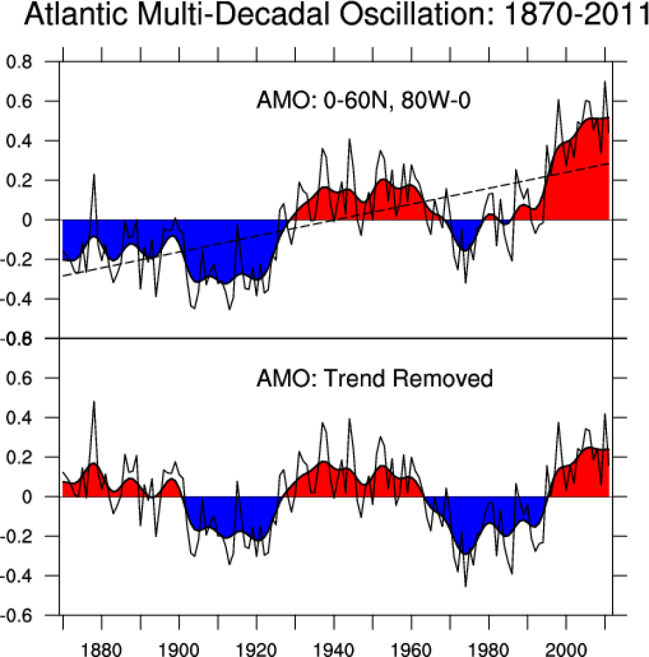
AMO (Atlantic Multidecadal Oscillation) Index. [Climate Data Guide; D. Shea]
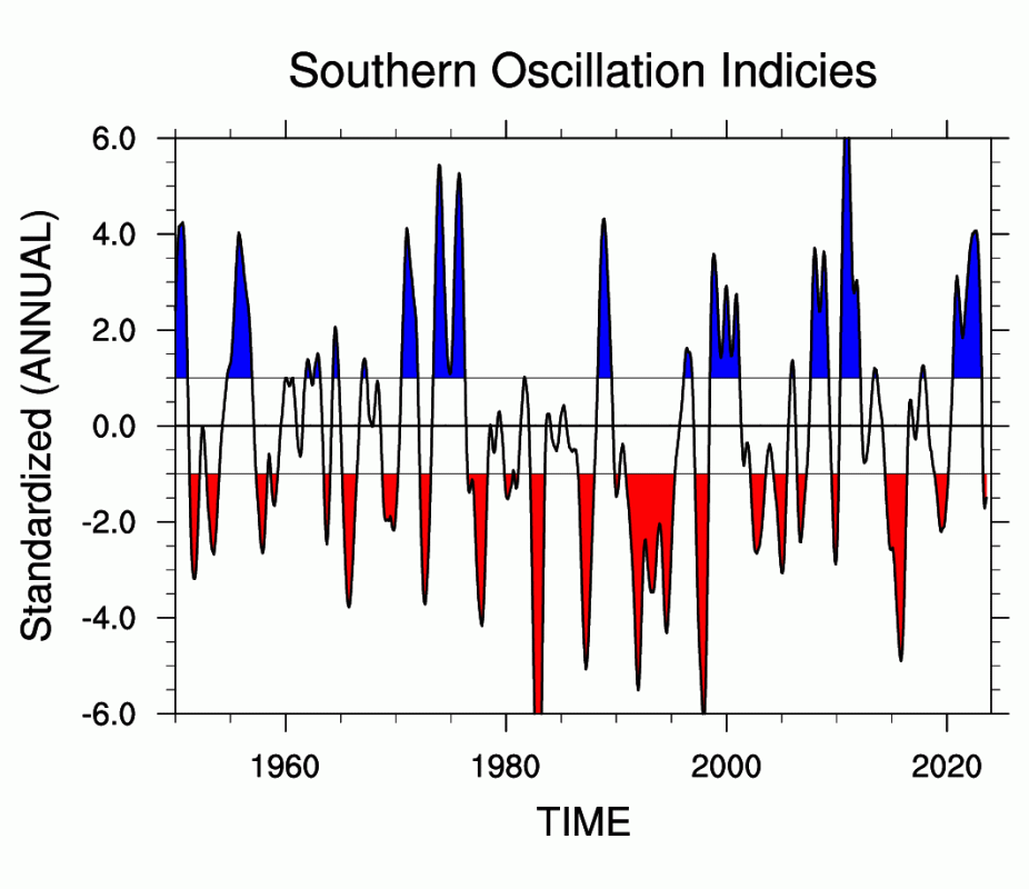
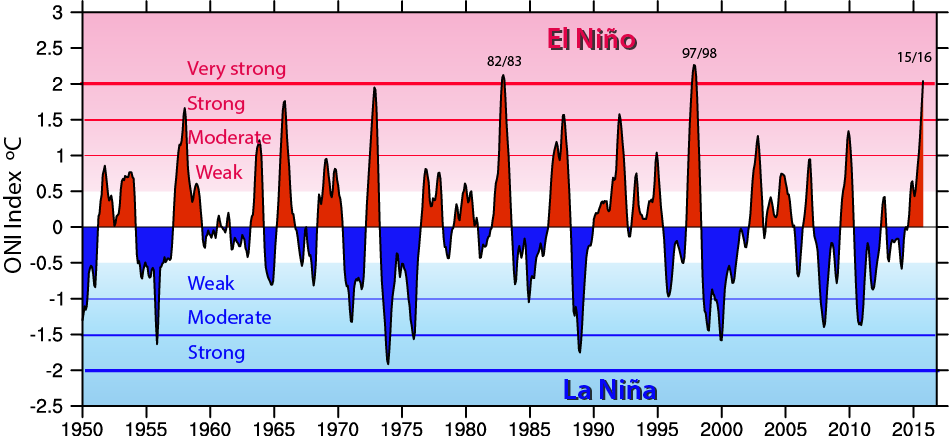
Southern Oscillation Index (SOI) from 1950-2022 based on annual standardization. Values +/- one standard deviation are colored: red corresponds to El Nino conditions; blue corresponds to La Nina conditions. [Climate Data Guide; D. Shea]
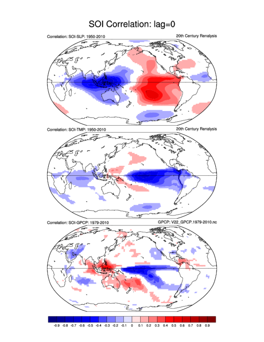
SOI contemporaneously (lag=0) correlated with various variables obtained from the 20th Century Reanalysis. [Climate Data Guide; D. Shea]
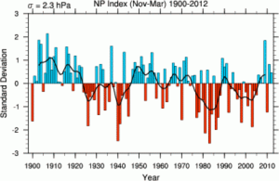
North Pacific (NP) Index (area-weighted sea level pressure over the region 30°N-65°N, 160°E-140°W) for period 1900-2012. The smooth line was derived using a simple weighted running average.[Climate Data Guide; A. Phillips]
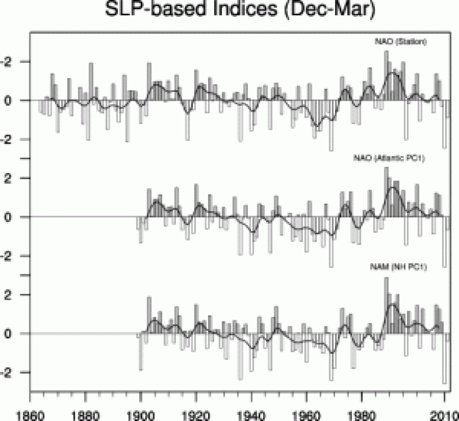
Time series of the various NAO and NAM indices. They are highly correlated. [CLimate Data Guide; A. Phillips]
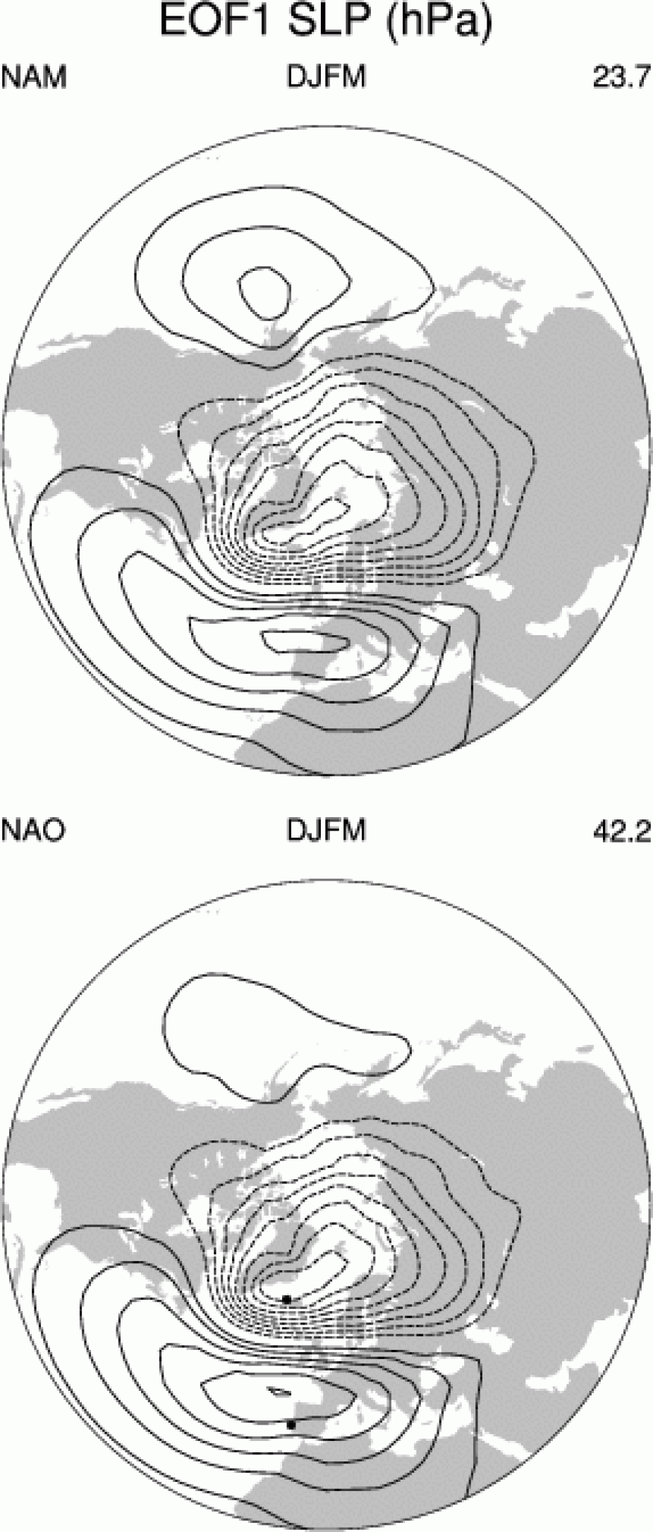
The NAM pattern (top) explains ~24% of the extended winter-mean (DJFM) variance, and is clearly dominated by the NAO structure in the Atlantic sector. Although there are some subtle differences from the regional pattern of the NAO (EOF1 of DJFM North Atlantic SLP; bottom) over the Atlantic and Arctic, the main difference is larger amplitude anomalies over the North Pacific of the same sign as those over the Atlantic. This feature gives the NAM a more annular (or zonally-symmetric) structure. [Climate Data Guide; A. Phillips]

Standardized Precipitation Index (SPI) at Boulder, Colorado for different run lengths. The World Meteorological Organization (WMO) recommends, that all national meteorological and hydrological services should use the SPI for monitoring of dry spells. [Climate Data Guide; D. Shea]
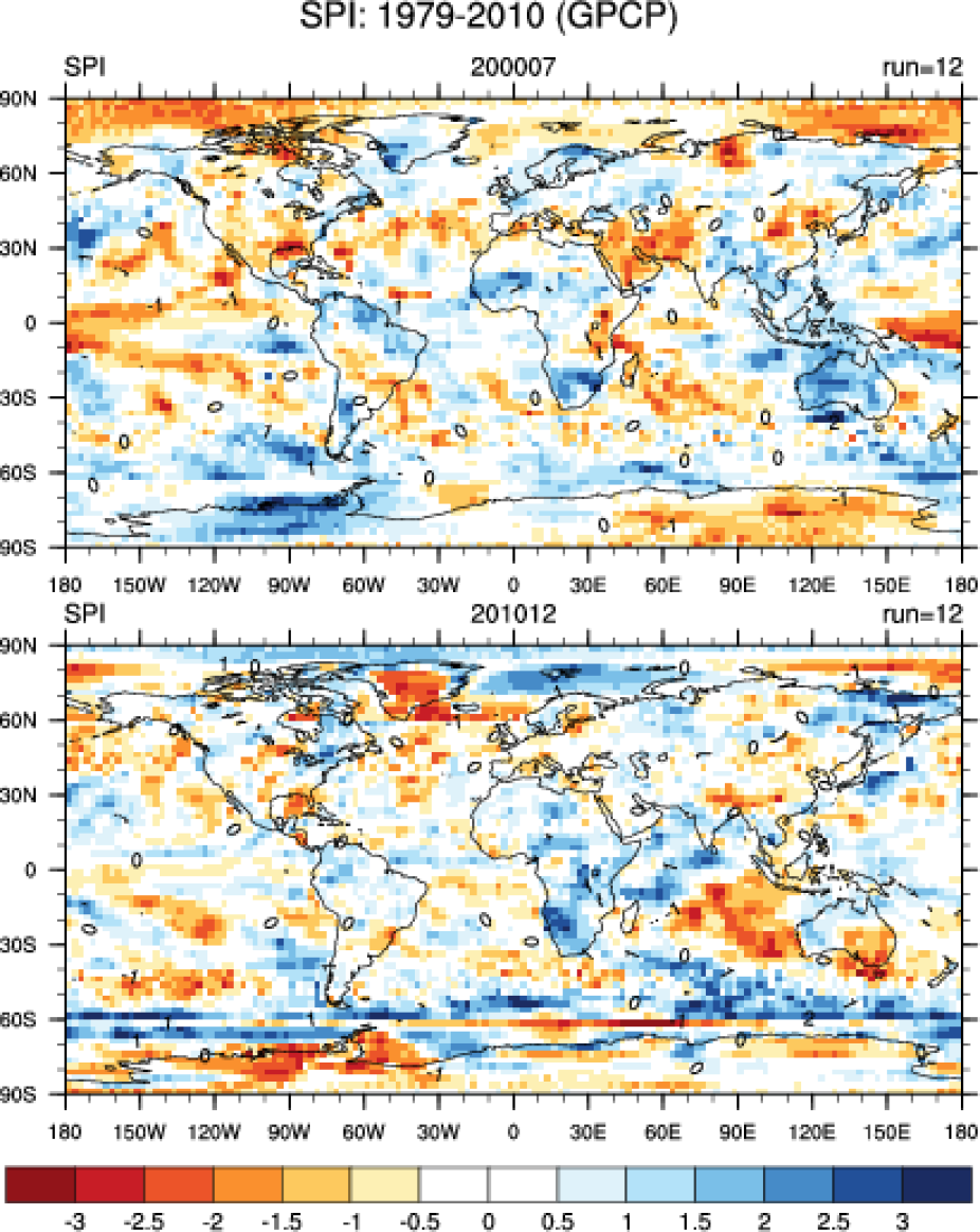
SPI over globe at July 2000 and December 2012 for run length of 12 months derived using the GPCP monthly precipitation data set. [Climate Data Guide; D. Shea].

NAO: The principal component (PC) time series of the leading EOF of DJFM SLP anomalies over the Atlantic sector (20-80N, 90W-40E) serves as an alternative index (see Hurrell (2003) and Hurrell (1995) below). The DJFM principal component timeseries is shown below in color, and the station based index is given by the thick black line. The correlation between the two is 0.93 over the period 1899-2013. The black dots on the EOF panel show the location of the stations used in the DJFM station-based index. [Climate Data Guide; A. Phillips]
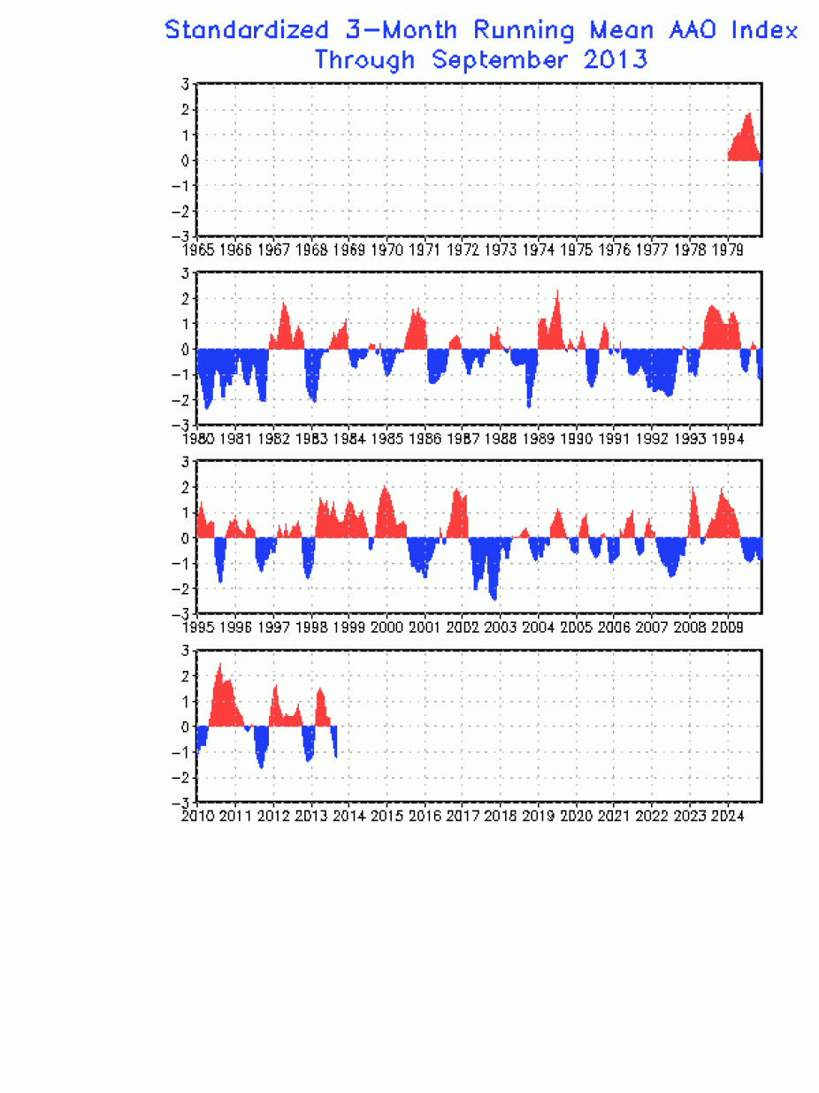
The standardized 3-month running mean value of the AAO index. Source: http://www.cpc.ncep.noaa.gov/products/precip/CWlink/daily_ao_index/aao/…
Other Information
- Marshall, G. J., 2003: Trends in the Southern Annular Mode from observations and reanalyses. J. Clim., 16, 4134-4143.
- Hurrell, J.W. (1995): Decadal Trends in the North Atlantic Oscillation: Regional Temperatures and Precipitation. Science 4 August 1995: Vol. 269 no. 5224 pp. 676-679
- Hurrell, J.W. and C. Deser (2009): North Atlantic climate variability: The role of the North Atlantic Oscillation. Journal of Marine Systems Volume 78, Issue 1, August 2009, Pages 28–41
- Hurrell et al. (2003) in The North Atlantic Oscillation: Climate Significance and Environmental Impact, 2003. J.W. Hurrell, Y. Kushnir, G. Ottersen, and M. Visbeck, Eds. Geophysical Monograph Series, 134, 279pp
- Trenberth, K. E., 1984: Signal versus noise in the Southern Oscillation, Mon. Wea. Rev.,. 112, 326-332
- Guttman, N.B. (1999): ACCEPTING THE STANDARDIZED PRECIPITATION INDEX: A CALCULATION ALGORITHM. Journal of the American Water Resources Association, Vol. 35, NO.2 AMERICAN WATER RESOURCES ASSOCIATION
- McRoberts, D. Brent, John W. Nielsen-Gammon, 2012: The Use of a High-Resolution Standardized Precipitation Index for Drought Monitoring and Assessment. J. Appl. Meteor. Climatol., 51, 68–83.
- Stammerjohn, S. E. et al (2008), Trends in Antarctic annual sea ice retreat and advance and their relation to El Nin ̃o – Southern Oscillation and Southern Annular Mode variability, J. Geophys. Res. , 113 , C03S90
- Heim, Jr., Richard R., 2002: A review of Twentieth-Century drought indices used in the United States. Bulletin of the American Meteorological Society, vol. 83, pp. 1149-1165.