Climate Data
The Climate Data Guide is a high-traffic expert knowledge portal providing concise and reliable information on the data that are essential for monitoring and understanding the Earth System. Currently, it curates expert insights on over 200 observational datasets and indices, searchable or browseable in the list below.
To find a specific dataset or climate variable, jump to the the search box. For only the datasets paired with guidance written by experts, select the "Datasets with guidance" button when using the search box.
Data creators, data publishers, and scientists who use climate data are invited to join our Network of Experts by contributing commentaries on data strengths and limitations to the Climate Data Guide. What type of data are included? See this discussion.
With the exception of about 25 climate indices, the Climate Data Guide does not host datasets. Data cannot be downloaded from this site. However, links are provided to download locations under the "Data Access" section of each dataset page.
Citation: Please link to this website in your work that draws upon material from this website, and cite this paper:
Schneider, D. P., C. Deser, J. Fasullo, and K. E. Trenberth, 2013: Climate Data Guide Spurs Discovery and Understanding. Eos Trans. AGU, 94, 121–122, https://doi.org/10.1002/2013eo130001.
=> Additionally, each dataset page with expert-written guidance has its own citation example on the individual page, such that the experts who wrote the guidance may be credited. Finally, responsible use and citation of datasets is strongly encouraged.
Climate datasets
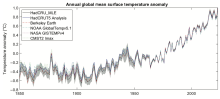 Global surface temperature: Maximum Likelihood Estimates of Temperatures using HadCRUT5 (Version 1.2)
Years of Record
- 1850-01 to 2023-12
The Maximum Likelihood Estimates of Temperatures using HadCRUT5 Version 1.2 (HadCRU_MLE_v1.2) dataset provides global complete surface temperature estimates since 1850, with monthly 5°x5° resolution. It uses more sophisticated statistical models to fill data gaps in…
Main variables and Earth System components
Atmosphere Air Temperature at 2m Ocean SST - sea surface temperatureExperts contributing reviews
- Chan, Duo
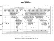 Gridded Climatology of Clouds from Surface Observations Worldwide (1971-2008)
Years of Record
- 1954-01 to 2009-12
This digital archive provides multi-year monthly, seasonal, and annual averages in 5x5-degree grid boxes (or 10x10-degree boxes for some quantities over the ocean). Daytime and nighttime averages, as well as the diurnal average (average of day and night), are given.…
-
Formats
- ascii
-
Timestep
- Climatology, Monthly, Seasonal
-
Domain
- Global
-
Collections
- Diagnostic Data Sets, NCAR-DOE-CESM, atmosdiagnostics
Experts contributing reviews
- Norris, Joel
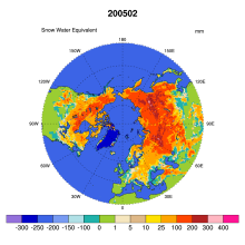 Global Monthly EASE-Grid Snow Water Equivalent Climatology: SSMR, SSMI
Years of Record
- 1978-11 to 2007-05
This data set comprises global, monthly satellite-derived snow water equivalent (SWE) climatologies from November 1978 through May 2007, and is updated with more recent data periodically. Global data are gridded to the Northern and Southern 25 km Equal-Area Scalable Earth…
-
Formats
- binary
-
Timestep
- Monthly
-
Collections
- None
Experts contributing reviews
- None
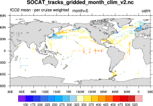 SOCAT: Surface Ocean CO2 Atlas
Years of Record
- 1970-01 to 2007-12
SOCAT (Surface Ocean CO2 Atlas) represents an effort to "provide a comprehensive, publicly available, regularly updated, global data set of marine surface CO2, which had been subject to quality control (QC)." The data sets are comprised of observations (ship track)…
-
Formats
- netCDF
-
Timestep
- Climatology, Monthly, Annual
-
Domain
- Global
-
Collections
- Carbon cycle
Experts contributing reviews
- None
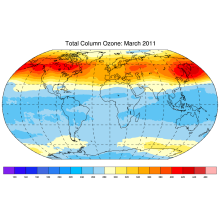 Total Column Ozone: Bodeker Scientific
Years of Record
Bodeker Scientific produces global, daily, total column ozone database by combining measurements from a number of different satellite-based instruments. Offsets and drifts between the different datasets are resolved through comparisons with the Dobson and Brewer ground-…
Experts contributing reviews
- None
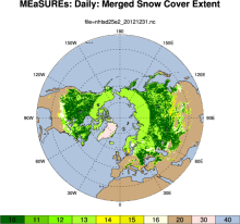
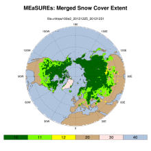 MEaSUREs: Northern Hemisphere Terrestrial Snow Cover Extent Weekly 100km EASE-Grid 2.0
Years of Record
- 1966-10 to 2012-12
"This data set offers users weekly 100 km Northern Hemisphere snow cover extent represented by three different variables. Two of the variables are derived from individual source products: the NOAA/NCDC Northern Hemisphere Snow Cover Extent Climate Data Record and Defense…
-
Formats
- netCDF
-
Timestep
- Weekly
-
Domain
- NH - Northern Hemisphere
-
Collections
- Climate Data Record
Experts contributing reviews
- None
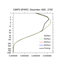 Stratospheric & Tropospheric Ozone: ACC/SPARC (Atmospheric Chemistry and Climate / Stratospheric Processes and their Role in Climate)
Years of Record
- 1850-01 to 2099-12
"The AC&C/SPARC ozone database covers the period 1850 to 2100 and can be used as forcing in climate models that do not include interactive chemistry. The historical part of the AC&C/SPARC ozone database spans the period 1850 to 2009 and consists of separate…
-
Formats
- netCDF
-
Timestep
- Monthly
-
Domain
- Global
-
Collections
- Boundary Conditions, CMIP5-recommended, AC&C/SPARC ozone
Experts contributing reviews
- None
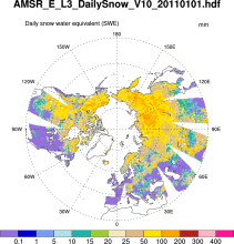 Snow Water Equivalent (AMSR-E)
Years of Record
- 2002-06 to 2011-10
The Advanced Microwave Scanning Radiometer-Earth Observing System (AMSR-E) distributes daily, weekly, and monthly products which includes snow water equivalent. Note: "On 04 October 2011, the AMSR-E instrument on board the Aqua satellite stopped producing data due to a…
-
Formats
- HDF-EOS
-
Timestep
- Daily, Monthly, Weekly
-
Domain
- NH - Northern Hemisphere
-
Collections
- None
Experts contributing reviews
- None
 PACIFICA: PACIFic ocean Interior CArbon
Years of Record
- 1988-01 to 2000-12
PACIFICA (PACIFic ocean Interior CArbon) was an international collaborative project for the data synthesis of ocean interior carbon and its related parameters in the Pacific Ocean. The North Pacific Marine Science Organization (PICES), Section of Carbon and Climate (S-CC…
-
Formats
- ascii
-
Timestep
- Sub-daily
-
Domain
- Pacific Ocean
-
Collections
- Carbon cycle
Experts contributing reviews
- None
 MEaSUREs Northern Hemisphere Terrestrial Snow Cover Extent Daily 25km EASE-Grid 2.0
Years of Record
- 1999-01 to 2012-01
"This data set offers users 25 km Northern Hemisphere snow cover extent represented by four different variables. Three of the snow cover variables are derived from the Interactive Multisensor Snow and Ice Mapping System, MODIS Cloud Gap Filled Snow Cover, and passive…
-
Formats
- netCDF
-
Timestep
- Daily
-
Domain
- NH - Northern Hemisphere
-
Collections
- None
Experts contributing reviews
- None
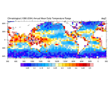 HadDTR: Hadley Centre sea-surface temperature diurnal temperature range climatology
Years of Record
The Hadley Centre sea-surface temperature diurnal temperature range climatology is a 5x5 degree gridded climatology of the diurnal range of sea surface temperature as measured by drifting buoys.
Experts contributing reviews
- None
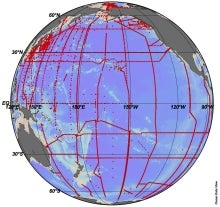
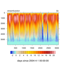 RAPID: monitoring the Atlantic Meridional Overturning Circulation at 26.5°N
Years of Record
- 2004-04 to 2017-02
"The Rapid Climate Change programme (RAPID) explores what causes rapid switches in climate, with a main (but not exclusive) focus on the Atlantic Ocean's thermohaline circulation." "A principal objective of the RAPID programme is the development and maintenance of a pre-…
Main variables and Earth System components
Ocean Salinity Sub Surface Temperature heat flux streamfunction-
Timestep
- Sub-daily
-
Domain
- Atlantic Ocean
-
Collections
- Diagnostic Data Sets
Experts contributing reviews
- None
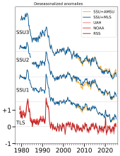 Stratospheric Temperature: Satellite Datasets Used to Quantify Lower, Middle, and Upper Stratospheric Temperatures
Years of Record
- 1989-01 to 2025-01
The temperature of the stratosphere is a key climate variable for understanding variability and change of the Earth's radiation budget, particularly due to sensitivity to changes in stratospheric ozone as well as aerosols from volcanoes and wildfires. While there are…
-
Formats
-
Timestep
- Monthly
-
Domain
- Global
-
Collections
- BAMS State of the Climate
Experts contributing reviews
- Randel, Bill | Starr, Jon
 CARINA: Carbon in the North Altantic
Years of Record
- 1978-01 to 2006-12
The CARINA (CARbon dioxide IN the Atlantic Ocean) data synthesis project is an international collaborative effort of the EU IP CARBOOCEAN, and US partners. It has produced a merged internally consistent data set of open ocean subsurface measurements for biogeochemical…
-
Formats
- ascii
-
Timestep
- Sub-daily
-
Domain
- Arctic, Atlantic Ocean, Southern Ocean
-
Collections
- Carbon cycle
Experts contributing reviews
- None
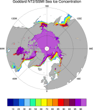 Sea ice concentration data from NASA Goddard based on SSMI and NASA Team (NT2) algorithm
Years of Record
- 1992-01 to 2008-04
The NASA Team 2 (NT2) / SSMI data set of Arctic and Antarctic sea ice concentration is available at daily timesteps and 25km spatial resolution for 1992-2008. NT2, an extension of the original NASA Team algorithm, uses SSMI 85GHz channels to help resolve ambiguity between…
Experts contributing reviews
- None
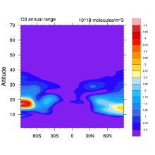
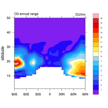 Stratospheric Ozone: Randel & Wu 2007
Years of Record
- 1979-01 to 2005-12
This is a monthly, zonal-mean ozone profile data set spanning 1979–2005 for altitudes from the tropopause up to 50 km. Interannual variability is based on a combination of SAGE (Stratospheric Aerosol and Gas Experiment) satellite profile measurements and polar ozonesondes…
-
Formats
- binary
-
Timestep
- Monthly
-
Domain
- Global
-
Collections
- Boundary Conditions
Experts contributing reviews
- Randel, Bill
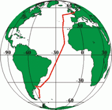 Atlantic Meridional Transect (AMT)
Years of Record
- 1995-01 to 2005-12
"The Atlantic Meridional Transect (AMT) is a multidisciplinary programme which undertakes biological, chemical and physical oceanographic research during an annual voyage between the UK and destinations in the South Atlantic." As of early November, 2013, there have been…
Main variables and Earth System components
-
Formats
- ascii
-
Timestep
- Sub-daily
-
Domain
- Atlantic Ocean
-
Collections
- Carbon cycle
Experts contributing reviews
- None
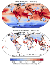 Equivalent Temperature: HadISDH.land and ERA5
Years of Record
- 1973-01 to 2024-01
Equivalent temperature is a measure of heat in the atmosphere that accounts for the latent heat stored in water vapor in addition to sensible heat as measured by temperature. The equivalent temperature ($T_e$) scales linearly with the moist enthalpy (i.e., the temperature…
-
Formats
-
Timestep
- Monthly
-
Domain
- Global
-
Collections
- BAMS State of the Climate
Experts contributing reviews
- Matthews, Tom
 Stratospheric Ozone: Vertically Resolved, zonal mean based on BDBP
Years of Record
- 1979-01 to 2007-12
Combined monthly mean vertical ozone profile database spanning the period 1979 to 2007. The database is completely filled such that there are no missing data. The raw individual ozone data are sourced from the BDBP database. Monthly means are calculated from…
Experts contributing reviews
- Hassler, Birgit
Years of Record
- 1900-01 to 2024-12
Night Marine Air Temperature (NMAT) refers to measurements of air temperature recorded with thermometers on the weather stations of ships. NMAT is a highly correlated variable with Sea Surface Temperature (SST), capturing the temperature of the atmosphere near the surface…
-
Formats
- netCDF
-
Timestep
- Monthly
-
Domain
- Global
-
Collections
- BAMS State of the Climate
Experts contributing reviews
- Cornes, Richard
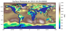 CAM6+DART Reanalysis and Surface Forcings
Years of Record
- 01-2011 to 12-2020
The CAM6+DART (Community Atmospheric Model version 6 + Data Assimilation Research Testbed) Reanalysis is an 80-member global atmospheric reanalysis with 6 hourly output from 2011-2020 on an approximately 1° lon-lat grid. This ensemble has two major features making it…
-
Formats
-
Timestep
- Sub-daily, Weekly
-
Domain
- Global
-
Collections
- Boundary Conditions
Experts contributing reviews
- Raeder, Kevin
Years of Record
Main variables and Earth System components
-
Formats
-
Timestep
-
Domain
-
Collections
- None
Experts contributing reviews
- None