Climate data guide content with tag AMSRE
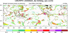 CMORPH (CPC MORPHing technique): High resolution precipitation (60S-60N)
Years of record
- to
"CMORPH (CPC MORPHing technique) produces global precipitation analyses at very high spatial and temporal resolution. This technique uses precipitation estimates that have been derived from low orbiter satellite microwave observations exclusively, and whose features are transported via spatial propagation information that is obtained entirely from geostationary satellite…
Experts contributing reviews
- N/A
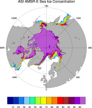 Sea Ice Concentration data from AMSR-E, AMSR2 & SSMIS, U Bremen and U Hamburg ASI algorithm
Years of record
- to
The sea ice data derived from AMSR-E using the ARTIST sea ice (ASI) algorithm offer a factor of 4 finer spatial resolution than most sea ice data sets from passive microwave satellite instruments. ASI is based on the difference of vertically and horizontally polarized brightness temperatures at 89 GHz; this difference is independent of temperature but depends on…
-
Timestep
- Daily
-
Collections
- N/A
Experts contributing reviews
- N/A
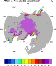 Sea Ice Concentration data from NASA Goddard and NSIDC using AMSR-E and NASA TEAM2 (NT2) algorithm
Years of record
- to
The AMSR-E/NASA Team 2 (NT2) data set of Arctic and Antarctic sea ice concentration is available at daily timesteps and 12.5 km (optionally 25km) spatial resolution for 2002-2011. NT2, an extension of the original NASA Team algorithm, uses AMSR-E 89GHz channels to help resolve ambiguity between low ice concentrations and areas with strong surface effects (due to snow…
Experts contributing reviews
- N/A
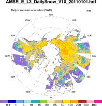 Snow Water Equivalent (AMSR-E)
Years of record
- to
The Advanced Microwave Scanning Radiometer-Earth Observing System (AMSR-E) distributes daily, weekly, and monthly products which includes snow water equivalent. Note: "On 04 October 2011, the AMSR-E instrument on board the Aqua satellite stopped producing data due to a problem with the rotation of its antenna."
-
Formats
- HDF-EOS
-
Timestep
- Daily, Monthly, Weekly
-
Domain
- NH - Northern Hemisphere
-
Collections
- N/A
Experts contributing reviews
- N/A
 SST (AMSR-E): Sea Surface Temperature from Remote Sensing Systems
Years of record
- to
High resolution (0.25°) SSTs were derived from the AMSR-E, a passive microwave radiometer flying on NASA's AQUA satellite. Remote Sensing Systems distributes the data in high spatial and temporal (daily, weekly, monthly) resolutions for both daytime and nighttime averages. Monthly versions are available on a 1°x1° grid from JPL PO-DAAC as well as the CMIP5 obs4MIPS…
Experts contributing reviews
- N/A
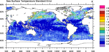
 SST data: NOAA High-resolution (0.25x0.25) Blended Analysis of Daily SST and Ice, OISSTv2
Years of record
- to
"NOAA’s Optimum Interpolation Sea Surface temperature (OISST, also known as Reynolds’ SST) is a series of global analysis products, including the weekly OISST on a 1° grid to the more recent daily on a ¼° grid. An SST analysis is a spatially gridded product created by interpolating and extrapolating data, resulting in a smoothed complete field. OISST provides global…
Main variables and Earth System components
Cryosphere Sea Ice Concentration Ocean SST - sea surface temperatureExperts contributing reviews
- Banzon, Viva, Reynolds, Richard
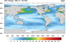 SST data: NOAA Optimal Interpolation (OI) SST Analysis, version 2 (OISSTv2) 1x1
Years of record
- to
The NOAA Optimal Interpolation SST analysis provides global, spatially complete SSTs on a weekly and monthly basis for 1982-present.
Experts contributing reviews
- Banzon, Viva, Reynolds, Richard