Sea Ice Concentration data from AMSR-E, AMSR2 & SSMIS, U Bremen and U Hamburg ASI algorithm
Key Strengths
Key Limitations
Spreen, G., L. Kaleschke, and G.Heygster(2008), Sea ice remote sensing using AMSR-E 89 GHz channels J. Geophys. Res.,vol. 113, C02S03, doi:10.1029/2005JC003384.
the data from Hamburg: Spreen, G., and L. Kaleschke (2008), "AMSR-E ASI 6.25 km Sea Ice Concentration Data, V5.5", Institute of Oceanography, University of Hamburg, Germany, digital media (ftp-projects.zmaw.de/seaice/).
none
Cite this page
Acknowledgement of any material taken from or knowledge gained from this page is appreciated:
National Center for Atmospheric Research Staff (Eds). Last modified "The Climate Data Guide: Sea Ice Concentration data from AMSR-E, AMSR2 & SSMIS, U Bremen and U Hamburg ASI algorithm.” Retrieved from https://climatedataguide.ucar.edu/climate-data/sea-ice-concentration-data-amsr-e-amsr2-ssmis-u-bremen-and-u-hamburg-asi-algorithm on 2026-07-07.
Citation of datasets is separate and should be done according to the data providers' instructions. If known to us, data citation instructions are given in the Data Access section, above.
Acknowledgement of the Climate Data Guide project is also appreciated:
Schneider, D. P., C. Deser, J. Fasullo, and K. E. Trenberth, 2013: Climate Data Guide Spurs Discovery and Understanding. Eos Trans. AGU, 94, 121–122, https://doi.org/10.1002/2013eo130001
Key Figures
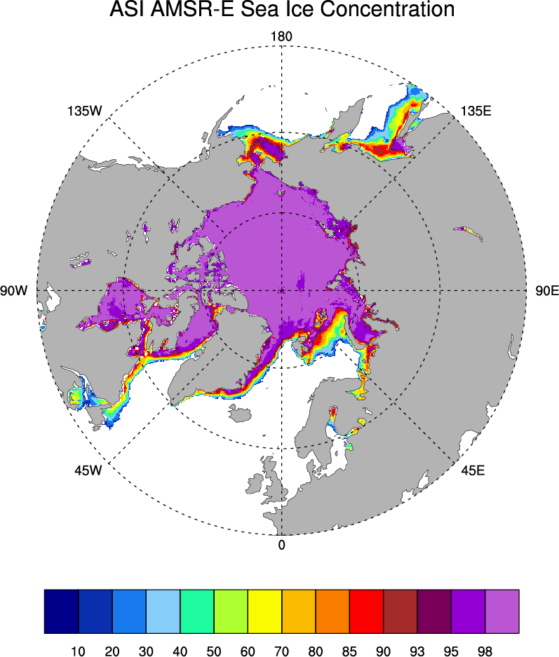
Average ice concentration in the Arctic in March for 2003-2007 based on the AMSR-E data and ASI algorithm. Figure by D. Schneider.
Other Information
- Spreen, G., L. Kaleschke, and G.Heygster(2008), Sea ice remote sensing using AMSR-E 89 GHz channels J. Geophys. Res.,vol. 113, C02S03, doi:10.1029/2005JC003384.
- Spreen, G., L. Kaleschke, and G. Heygster (2005), Operational Sea Ice Remote Sensing with AMSR-E 89 GHz Channels," 2005 IEEE International Geoscience and Remote Sensing Symposium Proceedings, IEEE 6, 4033-4036 (pdf)
- Kaleschke, L. and coauthors (2001), SSM/I remote sensing for mesoscale ocean-atmosphere interactions, Canadian Journal of Remote Sensing, 27(5), 526-537.
- Comiso, J. C., and K. Steffen (2008), Introduction to special section on Large-Scale Characteristics of the Sea Ice Cover from AMSR-E and Other Satellite Sensors, J. Geophys. Res., 113, C02S01, doi:10.1029/2007JC004442.