Cryosphere
Cryospheric variables include sea ice concentration, sea ice thickness, snow cover, glacier extent, and more. Overview pages summarize and compare selected datasets of a given variable.
To find a specific dataset or variable, jump to the search box below or click your desired variable from among the blue sub-category buttons.
To view only the datasets with commentaries from experts, select the "Datasets with guidance" button when using the search box.
Climate datasets
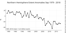
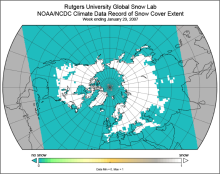 Snow Cover Extent (Northern Hemisphere) Climate Data Record, by Rutgers
Years of record
- to
The Snow Cover Extent Climate Data Record extends from the late 1960s to present. Historical analyses based on visual inspection have been digitized and combined with modern…
-
Timestep
- Monthly, Weekly
-
Domain
- North America
-
Collections
- Climate Data Record, Diagnostic Data Sets, NCAR-DOE-CESM, landdiagnostics
Experts contributing reviews
- Estilow, Thomas W. | Robinson, David
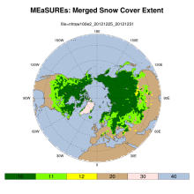
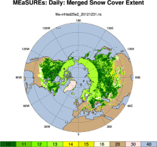 MEaSUREs Northern Hemisphere Terrestrial Snow Cover Extent Daily 25km EASE-Grid 2.0
Years of record
- to
"This data set offers users 25 km Northern Hemisphere snow cover extent represented by four different variables. Three of the snow cover variables are derived from the…
-
Formats
- netCDF
-
Timestep
- Daily
-
Domain
- NH - Northern Hemisphere
-
Collections
- N/A
Experts contributing reviews
- N/A
 MEaSUREs: Northern Hemisphere Terrestrial Snow Cover Extent Weekly 100km EASE-Grid 2.0
Years of record
- to
"This data set offers users weekly 100 km Northern Hemisphere snow cover extent represented by three different variables. Two of the variables are derived from individual…
-
Formats
- netCDF
-
Timestep
- Weekly
-
Domain
- NH - Northern Hemisphere
-
Collections
- Climate Data Record
Experts contributing reviews
- N/A
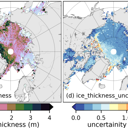
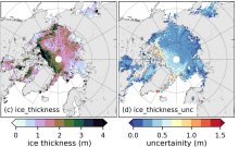 Sea Ice Thickness Data Sets: Overview & Comparison Table
Years of record
- to
While satellite observations of sea ice extent and concentration are available from 1979, long-term high quality (daily and high spatial resolution) observations of sea ice…
Experts contributing reviews
- Labe, Zachary | Tilling, Rachel
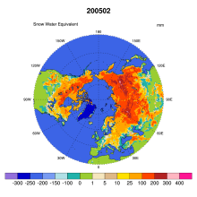 Global Monthly EASE-Grid Snow Water Equivalent Climatology: SSMR, SSMI
Years of record
- to
This data set comprises global, monthly satellite-derived snow water equivalent (SWE) climatologies from November 1978 through May 2007, and is updated with more recent data…
-
Formats
- binary
-
Timestep
- Monthly
-
Collections
- N/A
Experts contributing reviews
- N/A
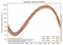
 NSIDC Sea Ice Index
Years of record
- to
The NSIDC Sea Ice Index is a suite of easy-to-use sea ice analyses to track changes in Arctic and Antarctic sea ice. The product is produced and supported by the NOAA at…
Experts contributing reviews
- Meier, Walter
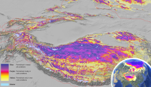 Global Permafrost Zonation Index Map
Years of record
- N/A
This data set contains a global (excluding Antarctica) 1 km map of permafrost zonation. It is an estimate of to what degree permafrost exists in a region nearly everywhere,…
Experts contributing reviews
- Gruber, Stephan
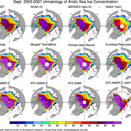
 Sea Ice Concentration Climate Data Record from OSI SAF
Years of record
- to
The Ocean and Sea Ice Satellite Applications Facility (OSI SAF) of EUMETSAT provides sea ice concentration products for the Arctic and Antarctic based on satellite passive…
-
Formats
- netCDF
-
Timestep
- Daily
-
Collections
- N/A
Experts contributing reviews
- Aaboe, Signe | Lavergne, Thomas
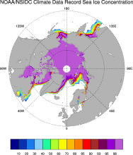 Sea Ice Concentration: NOAA/NSIDC Climate Data Record
Years of record
- to
The NOAA/NSIDC Climate Data Record (CDR) of sea ice concentration is available at 25 x 25 km spatial resolution in daily or monthly timesteps for 1987-2014. It provides a…
-
Formats
- netCDF
-
Timestep
- Daily, Monthly
-
Collections
- Climate Data Record
Experts contributing reviews
- Meier, Walter
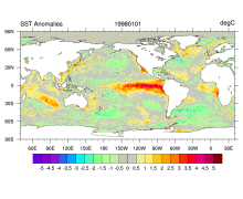 SST data: NOAA High-resolution (0.25x0.25) Blended Analysis of Daily SST and Ice, OISSTv2
Years of record
- to
"NOAA’s Optimum Interpolation Sea Surface temperature (OISST, also known as Reynolds’ SST) is a series of global analysis products, including the weekly OISST on a 1° grid…
Main variables and Earth System components
Cryosphere Sea Ice Concentration Ocean SST - sea surface temperatureExperts contributing reviews
- Banzon, Viva | Reynolds, Richard