Land
Important land variables include soil moisture, vegetation coverage, surface radiation budgets and more. Overview pages summarize and compare selected datasets of a given variable.
To find a specific dataset or variable, jump to the search box below or click your desired variable from among the blue sub-category buttons.
To see only the datasets accompanied by expert commentaries, select the "Datasets with guidance" button when using the search box.
Dataset Overviews
Sub-categories
Climate datasets
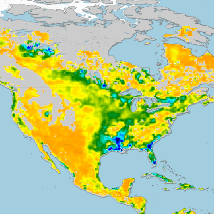
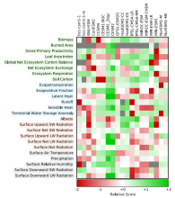
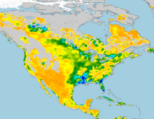 Soil Moisture Data Sets: Overview & Comparison Tables
Years of record
- N/A
Soil moisture is a state variable of the land that crosses the interfaces of several disciplines, including meteorology, hydrology, climatology and ecology. Soil moisture…
-
Formats
- N/A
-
Timestep
- N/A
-
Domain
- N/A
-
Collections
- Overview / Comparison page
Experts contributing reviews
- Dirmeyer, Paul
 SMAP-Derived 1-km Downscaled Surface Soil Moisture
Years of record
- to
This data product contains global daily 1 km resolution surface soil moisture (SM) derived from the Soil Moisture Active Passive (SMAP) L-band radiometer observations.…
-
Formats
- N/A
-
Timestep
- Daily
-
Domain
- Global
-
Collections
- N/A
Experts contributing reviews
- Lakshmi, Venkataraman | Fang, Bin
 Global Land Evaporation Amsterdam Model (GLEAM)
Years of record
- to
The Global Land Evaporation Amsterdam Model (GLEAM) is a satellite remote sensing-based set of algorithms dedicated to the estimation of evaporation and soil moisture at…
Main variables and Earth System components
Biosphere land evaporation Land evapotranspiration Soil Moisture-
Formats
- N/A
-
Timestep
- Daily
-
Domain
- Global
-
Collections
- N/A
Experts contributing reviews
- Miralles, Diego | Koppa, Akash
 Making sense of data from Land Surface Models (LSMs)
Years of record
- N/A
The land surface is a dynamic and complex component of the Earth system, shaping climate and biogeochemical cycles and serving as the origin of many anthropogenic impacts on…
-
Formats
- N/A
-
Timestep
- N/A
-
Domain
- N/A
-
Collections
- N/A
Experts contributing reviews
- Mankin, Justin | Lesk, Corey
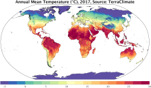 TerraClimate: Global, high-resolution gridded temperature, precipitation, and other water balance variables
Years of record
- to
TerraClimate is a global gridded dataset of meteorological and water balance variables for 1958-present, available on a monthly timestep. Its relatively fine spatial…
Main variables and Earth System components
Atmosphere Air Temperature Maximum Air Temperature Minimum Air Temperature Potential Evapotranspiration Precipitation Wind Snow Water Equivalent Land evapotranspiration Runoff and Streamflow Soil MoistureExperts contributing reviews
- Abatzoglou, John
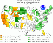 Palmer Drought Severity Index (PDSI)
Years of record
- N/A
The Palmer Drought Severity Index (PDSI) uses readily available temperature and precipitation data to estimate relative dryness. It is a standardized index that generally…
-
Timestep
- Monthly
-
Domain
- Global
-
Collections
- Climate Analysis Section (CAS) Data Catalog
Experts contributing reviews
- Dai, Aiguo
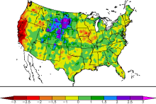 Standardized Precipitation Index (SPI)
Years of record
- to
The Standardized Precipitation Index (SPI) is a widely used index to characterize meteorological drought on a range of timescales. On short timescales, the SPI is closely…
-
Formats
- N/A
-
Timestep
- Monthly
-
Domain
- N/A
-
Collections
- N/A
Experts contributing reviews
- Keyantash, John
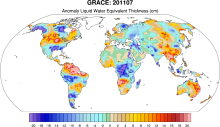 GRACE: Gravity Recovery and Climate Experiment: Surface mass, total water storage, and derived variables
Years of record
- to
The Gravity Recovery and Climate Experiment (GRACE) refers to a pair of NASA satellites that has flown in low-Earth orbit since 2002. The satellites use a precise microwave…
Main variables and Earth System components
Cryosphere Glaciers Ice Sheet Mass Land Groundwater surface water Water Storage Ocean Bottom pressure-
Timestep
- Daily, Monthly
-
Domain
- Global
-
Collections
- Diagnostic Data Sets, NCAR-DOE-CESM, landdiagnostics, landicediagnostics
Experts contributing reviews
- Swenson, Sean
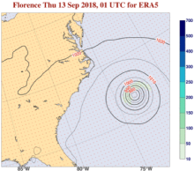 ERA5 atmospheric reanalysis
Years of record
- to
ERA5, the successor to ERA-Interim, provides global, hourly estimates of atmospheric, ocean-wave and land-surface variables, at a horizontal resolution of 31 km and 137…
-
Timestep
- Sub-daily, Daily, Monthly
-
Domain
- Global
-
Collections
- Diagnostic Data Sets
Experts contributing reviews
- Hersbach, Hans
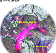 Arctic System Reanalysis (ASR)
Years of record
- to
The Arctic System Reanalysis is a multi-agency, university-led retrospective analysis (reanalysis) of the Greater Arctic. ASR is produced using high-resolution versions of…
Experts contributing reviews
- N/A
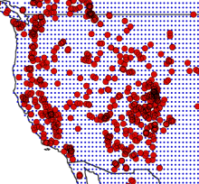 Drought atlases from tree rings
Years of record
- to
Tree-ring drought atlases provide a paleoclimate analog to modern drought indices, most commonly the Palmer Drought Severity Index (PDSI). Produced on a regular lat-…
-
Timestep
- Annual
-
Domain
- North America
-
Collections
- N/A
Experts contributing reviews
- Cook, Edward