Climate Data
The Climate Data Guide is a high-traffic expert knowledge portal providing concise and reliable information on the data that are essential for monitoring and understanding the Earth System. Currently, it curates expert insights on over 200 observational datasets and indices, searchable or browseable in the list below.
To find a specific dataset or climate variable, jump to the the search box. For only the datasets paired with guidance written by experts, select the "Datasets with guidance" button when using the search box.
Data creators, data publishers, and scientists who use climate data are invited to join our Network of Experts by contributing commentaries on data strengths and limitations to the Climate Data Guide. What type of data are included? See this discussion.
With the exception of about 25 climate indices, the Climate Data Guide does not host datasets. Data cannot be downloaded from this site. However, links are provided to download locations under the "Data Access" section of each dataset page.
Citation: Please link to this website in your work that draws upon material from this website, and cite this paper:
Schneider, D. P., C. Deser, J. Fasullo, and K. E. Trenberth, 2013: Climate Data Guide Spurs Discovery and Understanding. Eos Trans. AGU, 94, 121–122, https://doi.org/10.1002/2013eo130001.
=> Additionally, each dataset page with expert-written guidance has its own citation example on the individual page, such that the experts who wrote the guidance may be credited. Finally, responsible use and citation of datasets is strongly encouraged.
Climate datasets
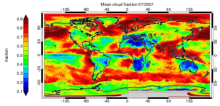 CLARA-A1: Cloud properties, surface albedo and surface radiation products based on AVHRR
Years of Record
- 1982-01 to 2009-12
"CLARA-A1 (CLoud, Albedo and RAdiation dataset, AVHRR-based, version 1) is a global dataset of cloud properties, surface albedo and surface radiation products, generated by the EUMETSAT Satellite Application Facility on Climate Monitoring (CM SAF). The products are derived…
Main variables and Earth System components
Atmosphere Cloud Properties Liquid Water Path Radiation Surface albedo-
Formats
- netCDF
-
Timestep
- Daily, Monthly, Pentad
-
Domain
- Global
-
Collections
- Climate Data Record
Experts contributing reviews
- Stengel, Martin
 Global near-surface humidity data: HadISDH
Years of Record
- 1973-01 to 2023-12
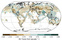
HadISDH (Met Office Hadley Centre International Surface Dataset of Humidity) is a gridded 5°x5° monthly mean product beginning in January 1973, and updated annually. It provides monthly gridded specific humidity (q), relative humidity (RH), vapor pressure (e), dew point…
Main variables and Earth System components
Atmosphere Air Temperature at 2m Relative Humidity Specific HumidityExperts contributing reviews
- Willett, Kate
 Lightning data from the TRMM and ISS Lightning Image Sounder (LIS): Towards a global lightning Climate Data Record
Years of Record
- 1998-01 to 2023-08
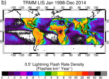
The Lightning Imaging Sensor (LIS) is an optically based spaceborne lightning detection instrument that has been hosted on two different platforms – the Tropical Rainfall Measuring Mission satellite (TRMM; 1998-2015; Kummerow et al. 1998) and the International Space…
Experts contributing reviews
- Lang, Timothy
 Surface Flux and Meteorological Dataset: National Oceanography Centre (NOC) V2.0
Years of Record
- 1973-01 to 2014-12
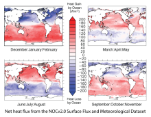
The National Oceanography Centre (NOC) Version 2.0 Surface Flux and Meteorological Dataset is a monthly mean gridded dataset of marine surface measurements and derived fluxes constructed using optimal interpolation. Input for the period 1973 to 2006 are ICOADS…
-
Formats
- netCDF
-
Timestep
- Monthly
-
Domain
- Global
-
Collections
- Climate Data Record
Experts contributing reviews
- Kent, Elizabeth
 Climate Data Records: Overview
Years of Record
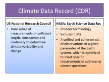
As defined by a US National Research Council committee, a Climate Data Record (CDR) is "a time series of measurements of sufficient length, consistency and continuity to determine climate variability and change." In the US, agencies such as NASA and NOAA have sponsored…
Main variables and Earth System components
-
Formats
-
Timestep
-
Domain
-
Collections
- Climate Data Record
Experts contributing reviews
- None
 ISCCP: International Satellite Cloud Climatology Project
Years of Record
- 1983-07 to 2009-12
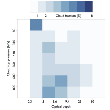
The International Satellite Cloud Climatology Project (ISCCP) makes use of routine observations by operational weather satellites to provide a long-term (1983-2009), gridded, global record of cloud properties. ISCCP uses observations in the visible and infrared window…
-
Timestep
- Climatology, Sub-daily, Monthly
-
Domain
- Global
Experts contributing reviews
- Pincus, Robert
 Sea Ice Concentration Climate Data Record from OSI SAF
Years of Record
- 1978-10 to 2023-08
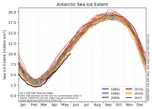
The Ocean and Sea Ice Satellite Applications Facility (OSI SAF) of EUMETSAT provides sea ice concentration products for the Arctic and Antarctic based on satellite passive microwave data. The concentration value is expressed as the fractional percentage of the ice cover…
-
Formats
- netCDF
-
Timestep
- Daily
-
Collections
- None
Experts contributing reviews
- Aaboe, Signe | Lavergne, Thomas
 Global surface temperature data: The Dynamically Consistent ENsemble of Temperature (DCENT)
Years of Record
- 1850 to Present
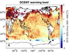
The Dynamically Consistent ENsemble of Temperature (DCENT) provides monthly, global, gridded, surface temperature anomalies since 1850. This product provides combined land surface air temperature (LSAT) and sea surface temperature (SST) anomalies at monthly 5° x 5°…
Main variables and Earth System components
Atmosphere Air Temperature at 2m Ocean SST - sea surface temperatureExperts contributing reviews
- Chan, Duo
 Historical land-cover changes and land-use conversions global data set by Meiyappan and Jain
Years of Record
- 1800-01 to 2010-12
A set of three estimates of land-cover types and annual transformations of land use are provided on a global 0.5°x0.5° grid at annual timesteps. The longest of the three estimates spans 1770-2010. The three estimates use three different data sets of cropland and…
Main variables and Earth System components
Land Land Cover Type Land Use Conversion Vegetation CoverExperts contributing reviews
- Meiyappan, Prasanth
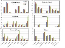
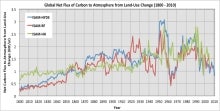 Carbon Emissions from Historical Land-Use and Land-Use Change
Years of Record
- 1800-01 to 2012-09
Annual net land-atmosphere carbon flux and net flux of carbon to the atmosphere due to land-use and land-use change (LULUC) are estimated using an integrated assessment model and three historical reconstructions of land use and land use conversion. The data span 1800-2010…
Main variables and Earth System components
Biosphere CO2 Land CO2 Land-Atmosphere flux Land Cover Type Land Use ConversionExperts contributing reviews
- Meiyappan, Prasanth
 HadIOD: Met Office-Hadley Centre Integrated Ocean Database
Years of Record
- 1850-01 to 2019-12
HadIOD (Met Office Hadley Centre Integrated Ocean Database) is a global database of in situ ocean temperature and salinity observations, spanning 1850-present on a daily timestep. It is somewhat unique among temperature and salinity datasets in that it combines…
Main variables and Earth System components
Ocean Salinity SST - sea surface temperature Sub Surface TemperatureExperts contributing reviews
- Atkinson, Chris
 Kaplan Sea Surface Temperature Anomalies
Years of Record
- 1856-01 to 2020-03
The most up-to-date version is known as Kaplan Extended SST v2, which combines statistically infilled grids of UK Met Office SSTs for 1856-1981 with a statistically reduced and coarser resolution version of Smith and Reynolds Optimally Interpolated (OI) SSTs for 1981 to…
Experts contributing reviews
- Kaplan, Alexy
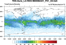 Water Isotopes from Satellites
Years of Record
- 2000-01 to 2012-09
Summary of 7 satellite-derived products providing a global snapshot of water isotope distribution in 3D, with good information on zonal gradients and seasonality.
Experts contributing reviews
- Risi, Camille
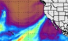
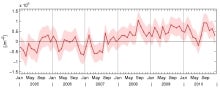 Ocean heat content for 10-1500m depth based on Argo
Years of Record
- 2005-01 to 2011-12
A regularly updated monthly timeseries of ocean heat content, based on Argo profiles, is integrated over 10-1500m depth and the latitudes 60°S-60°N. Coverage begins in 2005. It is estimated based on the method described in von Schuckmann and Le Traon (2011) and discussed…
Experts contributing reviews
- von Schuckmann, Karina
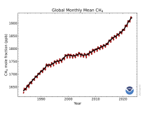 Global-mean methane at the Earth's surface from NOAA’s global cooperative greenhouse gas measurements
Years of Record
- 1983-01 to 2023-05
NOAA’s Global Monitory Laboratory has measured atmospheric methane levels since 1983 at a global cooperative greenhouse gases sampling network, which currently includes more than 50 sites. This measurement network is unique among greenhouse gases monitoring programs with…
Experts contributing reviews
- Lan, Xin
 MSU/AMSU Atmospheric Temperature Climate Data Record, Remote Sensing Systems (RSS)
Years of Record
- 1979-01 to 2012-12
A long (30-year+) data set of atmospheric temperatures for 4 tropopsheric and lower stratopsheric layers has been derived from brightness temperatures measured by the Microwave Sounding Unit (MSU) and Advanced Microwave Sounding Unit (AMSU). This page describes the data…
-
Timestep
- Monthly
-
Domain
- Global
-
Collections
- Climate Data Record
Experts contributing reviews
- Mears, Carl
 Walsh and Chapman Northern Hemisphere Sea Ice
Years of Record
- 1870-01 to 2011-12
The Walsh and Chapman Sea Ice Data Set provides a long record of Arctic sea ice concentrations on a monthly basis for 1870-2011. Historical observations were gridded and combined with satellite-derived sea ice concentrations for the recent decades. Mostly climatologies…
-
Formats
- ascii
-
Timestep
- Monthly
-
Domain
- NH - Northern Hemisphere, Arctic
-
Collections
- None
Experts contributing reviews
- Chapman, William
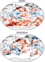 WASWind: Wave and Anemometer-based Sea Surface Wind
Years of Record
- 1950-01 to 2011-12
"WASWind (Wave and Anemometer-based Sea Surface Wind) provides a bias-corrected marine surface wind dataset over the global oceans. Variables include scalar, zonal and meridional winds at 10-meter high, and zonal and meridional components of wind stress. WASWind has been…
Experts contributing reviews
- Tokinaga, Hiroki
 Extended Edited Synoptic Cloud Reports Archive (EECRA) from Ships and Land Stations Over the Globe
Years of Record
- 1952-01 to 2008-12
"The Extended Edited Synoptic Cloud Reports Archive makes use of routine synoptic observations made by humans on ships over the ocean and at weather stations over land. Following the synoptic code (WMO, 1974), observers report the fraction of sky dome covered by all…
Experts contributing reviews
- Norris, Joel
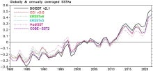
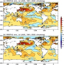 SST Data: NOAA Extended Reconstruction SSTs Version 6 (ERSSTv6)
Years of Record
- 1850-01 to 2025-01
The NOAA Extended Reconstruction Sea Surface Temperature version 6 (ERSSTv6) is a global, spatially complete SST data at monthly 2°×2° resolutions based on in situ observations for 1850-present. Version 6 is based upon statistical interpolation of the ICOADS release 3.0.2…
Experts contributing reviews
- Huang, Boyin | Yin, Xungang
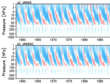 JRA-55C (reanalysis using conventional observations)
Years of Record
- 1972-10 to 2013-01
JRA-55C is a fixed observing system atmospheric reanalysis that uses the same model and data assimilation scheme as JRA-55. The observations assimilated include surface station data, radiosondes, tropical cyclone retrievals and wind profilers. No satellite…
Main variables and Earth System components
Experts contributing reviews
- Kobayashi, Chiaki
 Landscape surface freeze/thaw status based on passive microwave remote sensing
Years of Record
- 1979-01 to 2011-09
A global data set of the frozen state of the land surface (free-thaw (FT) status) has been developed spanning 1979-present at a daily timestep and 25 x 25 km spatial resolution. Based on passive microwave remote sensing, the FT parameter is closely related to the surface…
-
Timestep
- Daily
-
Domain
- Global
-
Collections
- Climate Data Record
Experts contributing reviews
- Kimball, John
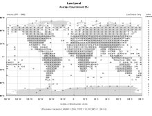 Gridded Climatology of Clouds from Surface Observations Worldwide (1971-2008)
Years of Record
- 1954-01 to 2009-12
This digital archive provides multi-year monthly, seasonal, and annual averages in 5x5-degree grid boxes (or 10x10-degree boxes for some quantities over the ocean). Daytime and nighttime averages, as well as the diurnal average (average of day and night), are given.…
-
Formats
- ascii
-
Timestep
- Climatology, Monthly, Seasonal
-
Domain
- Global
-
Collections
- Diagnostic Data Sets, NCAR-DOE-CESM, atmosdiagnostics
Experts contributing reviews
- Norris, Joel
 Atmospheric Rivers: The Atmospheric River Tracking Method Intercomparison Project (ARTMIP)
Years of Record
- 1980-01 to 2017-06
ARTMIP is the Atmospheric River Tracking Method Intercomparison Project. The goal of ARTMIP is to provide the community with the data necessary to quantify Atmospheric River (AR) uncertainty due to how ARs are defined or identified in gridded datasets. Atmospheric rivers…
Main variables and Earth System components
AtmosphereExperts contributing reviews
- None
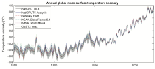 Global surface temperature: Maximum Likelihood Estimates of Temperatures using HadCRUT5 (Version 1.2)
Years of Record
- 1850-01 to 2023-12
The Maximum Likelihood Estimates of Temperatures using HadCRUT5 Version 1.2 (HadCRU_MLE_v1.2) dataset provides global complete surface temperature estimates since 1850, with monthly 5°x5° resolution. It uses more sophisticated statistical models to fill data gaps in…
Main variables and Earth System components
Atmosphere Air Temperature at 2m Ocean SST - sea surface temperatureExperts contributing reviews
- Chan, Duo
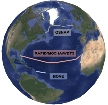 Observations of the Atlantic Meridional Overturning Circulation (AMOC)
Years of Record
The Atlantic Meridional Overturning Circulation (AMOC) is comprised of a series of northward surface currents and southward currents at depth in the Atlantic Basin. It is a key part of the global ocean circulation and is responsible for substantial oceanic heat transport…
Main variables and Earth System components
Ocean-
Formats
-
Timestep
-
Domain
-
Collections
- None
Experts contributing reviews
- Lankhorst, Matthias
 Total Column Water Vapor: Integrated Water Vapor from GNSS stations
Years of Record
- 1994-01 to 2024-12
Total Column Water Vapor (TCWV) or Integrated Water Vapor (IWV) is a key measure of the quantity of moisture held in the atmosphere at given locations. Water vapor is a key variable for understanding the moist energetics of the atmosphere and therefore the circulation as…
-
Formats
- ascii
-
Timestep
- Sub-daily, Daily, Monthly
-
Domain
- Global
-
Collections
- BAMS State of the Climate
Experts contributing reviews
- None
 SST data: NOAA daily Optimum Interpolation Sea Surface Temperature version 2.1, OISSTv2.1
Years of Record
- 1981-01 to 2025-01
NOAA’s daily Optimum Interpolation Sea Surface Temperature (dOISST, also known as Reynolds’ SST or OISST) is a global SST analysis product. An SST analysis is a spatially gridded product created by interpolating and extrapolating data, resulting in a smoothed spatially-…
Experts contributing reviews
- Huang, Boyin | Yin, Xungang
 Observations of Glacier Mass Balance: The World Glacier Monitoring Service
Years of Record
- 1949-01 to 2025-01
Mountain glaciers and ice caps have been studied as sensitive indicators of climate since the 19th century. The recognition of glacier sensitivity to climate led to the development of a global reporting system for glacier terminus change and glacier mass balance during…
-
Formats
-
Timestep
- Annual
-
Domain
- Global
-
Collections
- BAMS State of the Climate
Experts contributing reviews
- Pelto, Mauri
 SST Data: COBEv3: Centennial in situ Observation-Based Estimates Version 3
Years of Record
- 1900-01 to 2020-01
The Centennial in situ Observation-Based Estimates of Sea Surface Temperature version 3 (COBE-SST3) is a SST analysis produced by the Japanese Meteorological Agency (JMA). The main COBE-SST3 reconstruction provides spatially complete estimates of SST over the global…
Experts contributing reviews
- Ishii, Masayoshi
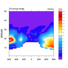 Stratospheric Ozone: Randel & Wu 2007
Years of Record
- 1979-01 to 2005-12
This is a monthly, zonal-mean ozone profile data set spanning 1979–2005 for altitudes from the tropopause up to 50 km. Interannual variability is based on a combination of SAGE (Stratospheric Aerosol and Gas Experiment) satellite profile measurements and polar ozonesondes…
-
Formats
- binary
-
Timestep
- Monthly
-
Domain
- Global
-
Collections
- Boundary Conditions
Experts contributing reviews
- Randel, Bill
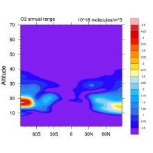 Stratospheric Ozone: Vertically Resolved, zonal mean based on BDBP
Years of Record
- 1979-01 to 2007-12
Combined monthly mean vertical ozone profile database spanning the period 1979 to 2007. The database is completely filled such that there are no missing data. The raw individual ozone data are sourced from the BDBP database. Monthly means are calculated from…
Experts contributing reviews
- Hassler, Birgit
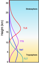
 Stratospheric Temperature: Satellite Datasets Used to Quantify Lower, Middle, and Upper Stratospheric Temperatures
Years of Record
- 1989-01 to 2025-01
The temperature of the stratosphere is a key climate variable for understanding variability and change of the Earth's radiation budget, particularly due to sensitivity to changes in stratospheric ozone as well as aerosols from volcanoes and wildfires. While there are…
-
Formats
-
Timestep
- Monthly
-
Domain
- Global
-
Collections
- BAMS State of the Climate
Experts contributing reviews
- Randel, Bill | Starr, Jon
 Lake Water Storage: GloLakes
Years of Record
- 1984-01 to 2025-01
Lakes and reservoirs are critical components of the hydrological cycle, particularly due to their central role in many human systems. Long-term measurements of lakes is critical for understanding the dynamics linking lake volume to the climate system and human activities…
-
Formats
-
Timestep
- Monthly
-
Domain
- Global
-
Collections
- BAMS State of the Climate
Experts contributing reviews
- None
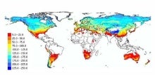
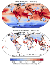 Equivalent Temperature: HadISDH.land and ERA5
Years of Record
- 1973-01 to 2024-01
Equivalent temperature is a measure of heat in the atmosphere that accounts for the latent heat stored in water vapor in addition to sensible heat as measured by temperature. The equivalent temperature ($T_e$) scales linearly with the moist enthalpy (i.e., the temperature…
-
Formats
-
Timestep
- Monthly
-
Domain
- Global
-
Collections
- BAMS State of the Climate
Experts contributing reviews
- Matthews, Tom
Years of Record
- 1900-01 to 2024-12
Night Marine Air Temperature (NMAT) refers to measurements of air temperature recorded with thermometers on the weather stations of ships. NMAT is a highly correlated variable with Sea Surface Temperature (SST), capturing the temperature of the atmosphere near the surface…
-
Formats
- netCDF
-
Timestep
- Monthly
-
Domain
- Global
-
Collections
- BAMS State of the Climate
Experts contributing reviews
- Cornes, Richard