Climate Data
The Climate Data Guide is a high-traffic expert knowledge portal providing concise and reliable information on the data that are essential for monitoring and understanding the Earth System. Currently, it curates expert insights on over 200 observational datasets and indices, searchable or browseable in the list below.
To find a specific dataset or climate variable, jump to the the search box. For only the datasets paired with guidance written by experts, select the "Datasets with guidance" button when using the search box.
Data creators, data publishers, and scientists who use climate data are invited to join our Network of Experts by contributing commentaries on data strengths and limitations to the Climate Data Guide. What type of data are included? See this discussion.
With the exception of about 25 climate indices, the Climate Data Guide does not host datasets. Data cannot be downloaded from this site. However, links are provided to download locations under the "Data Access" section of each dataset page.
Citation: Please link to this website in your work that draws upon material from this website, and cite this paper:
Schneider, D. P., C. Deser, J. Fasullo, and K. E. Trenberth, 2013: Climate Data Guide Spurs Discovery and Understanding. Eos Trans. AGU, 94, 121–122, https://doi.org/10.1002/2013eo130001.
=> Additionally, each dataset page with expert-written guidance has its own citation example on the individual page, such that the experts who wrote the guidance may be credited. Finally, responsible use and citation of datasets is strongly encouraged.
Climate datasets
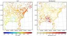
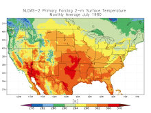 NLDAS: North American Land Data Assimilation System
Years of Record
- 1979-01 to 2023-08
The North American Land Data Assimilation System (NLDAS) integrates a large quantity of observation-based and model reanalysis data to produce long-term hourly atmospheric forcing data, and then uses this meteorological data to drive offline (not coupled to the atmosphere…
Main variables and Earth System components
Atmosphere Air Temperature CAPE Evaporation Precipitation Radiation Specific Humidity Surface Pressure Wind-
Timestep
- Climatology, Sub-daily, Monthly
-
Domain
- North America
-
Collections
- None
Experts contributing reviews
- Xia, Youlong | Mocko, David
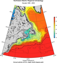 World Ocean Atlas 2013 (WOA13)
Years of Record
- 1955-01 to 2012-12
The World Ocean Atlas (WOA) is a set of climatological mean, gridded fields of oceanographic variables based on in-situ measurements from a wide variety of sources. Global, decadal averages of temperature, salinity, oxygen and nutrients are provided at monthly,…
Main variables and Earth System components
Ocean Dissolved Oxygen phosphate potential temperature silicate SST - sea surface temperature Sub Surface Salinity Sub Surface Temperature Sub-surface data-
Timestep
- Climatology, Monthly, Seasonal
-
Domain
- Global
-
Collections
- Diagnostic Data Sets, NCAR-DOE-CESM, oceandiagnostics
Experts contributing reviews
- Mishonov, Alexey
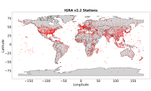 Integrated Global Radiosonde Archive (IGRA)
Years of Record
- 1905-01 to 2023-09
The largest publicly available collection of quality-controlled, globally-distributed, historical radiosonde and pilot balloon observations is the Integrated Global Radiosonde Archive (IGRA; Durre et al. 2006, 2018). First released in 2004, IGRA is maintained and…
Main variables and Earth System components
Atmosphere Dew Point Temperature Geopotential Height Multiple variables Relative Humidity WindExperts contributing reviews
- Durre, Imke | Korzeniewski, Bryant
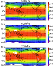
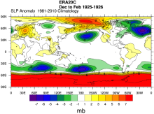 ERA-20C: ECMWF's atmospheric reanalysis of the 20th century (and comparisons with NOAA's 20CR)
Years of Record
- 1900-01 to 2011-01
The ECMWF's first atmospheric reanalysis of the 20th Century, ERA-20C, provides a long, gridded dataset of many climate variables, spanning 1900-2010. Observations assimilated include surface pressures from the International Surface Pressure Databank v3.2.6 and…
-
Timestep
- Sub-daily, Daily, Monthly
-
Domain
- Global
Experts contributing reviews
- Poli, Paul
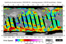 QuikSCAT: near sea-surface wind speed and direction
Years of Record
- 1999-08 to 2009-10
The QuikSCAT mission was intended to obtain sea-surface wind speed and direction data under all weather and cloud conditions over Earth's oceans. SeaWinds, an active radar scatterometer, is the main instrument on the QuikSCAT satellite. The microwave backscatter measured…
Experts contributing reviews
- Ricciardulli, Lucrezia
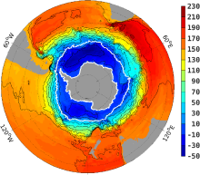
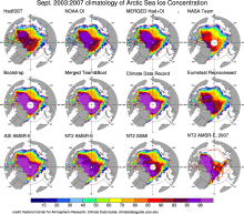 Sea Ice Concentration data: Overview, Comparison table and graphs
Years of Record
Sea ice concentration is both an indicator and driver of changes high-latitude climate with strong societal and ecological importance. It is a key boundary condition for atmospheric models (including those used in atmospheric reanalyses) and a benchmark for coupled…
-
Formats
-
Timestep
-
Collections
- Overview / Comparison page
Experts contributing reviews
- None
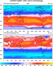 CERES EBAF: Clouds and Earth's Radiant Energy Systems (CERES) Energy Balanced and Filled (EBAF)
Years of Record
- 2000-03 to 2017-02
The CERES-EBAF product provides 1-degree regional, zonal and global monthly mean Top-of-Atmosphere (TOA) and surface (SFC) longwave (LW), shortwave (SW), and net (NET) fluxes under clear and all-sky conditions. EBAF is used for climate model evaluation, estimating…
Experts contributing reviews
- Loeb, Norman
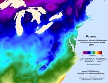 Daymet: Daily Surface Weather and Climatological Summaries
Years of Record
- 1980-01 to 2023-07
Daymet provides long-term, continuous, gridded estimates of daily weather and climatology variables by interpolating and extrapolating ground-based observations through statistical modeling techniques. The Daymet data products provide driver data for biogeochemical…
Main variables and Earth System components
Atmosphere Maximum Air Temperature Minimum Air Temperature Precipitation Radiation Water Vapor Cryosphere Snow Water Equivalent-
Timestep
- Climatology, Daily
-
Domain
- North America
-
Collections
- None
Experts contributing reviews
- Thornton, Peter E
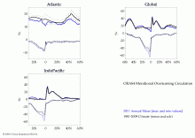
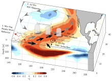 Meridional Modes and their indices
Years of Record
In each of the world’s tropical ocean basins, year-to-year climate variability is primarily governed by fluctuations in the zonal sea surface temperature (SST) gradient and zonal surface winds. These variations consist of recognizable climate modes, such as the El Niño-…
-
Formats
-
Timestep
-
Domain
- Atlantic Ocean, Pacific Ocean
-
Collections
- None
Experts contributing reviews
- Amaya, Dillon
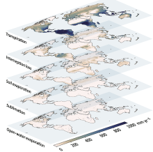 Global Land Evaporation Amsterdam Model (GLEAM)
Years of Record
- 1980-01 to 2022-12
The Global Land Evaporation Amsterdam Model (GLEAM) is a satellite remote sensing-based set of algorithms dedicated to the estimation of evaporation and soil moisture at global scales (Miralles et al. 2011). The current version of GLEAM (version 3) operates at a daily…
Main variables and Earth System components
Biosphere land evaporation Land evapotranspiration Soil Moisture-
Formats
-
Timestep
- Daily
-
Domain
- Global
-
Collections
- None
Experts contributing reviews
- Miralles, Diego | Koppa, Akash
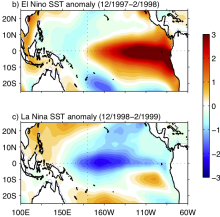 Asymmetry and Diversity in the pattern, amplitude and duration of El Niño and La Niña
Years of Record
El Niño and La Niña, the two phases of ENSO, are sometimes described as opposites. However, there are asymmetries in their spatial structure, amplitude, duration and seasonal evolution. This leads to differing teleconnections and global impacts, as well as implications…
-
Formats
-
Timestep
-
Domain
- Tropics
-
Collections
- None
Experts contributing reviews
- Santoso, Agus
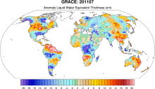 GRACE: Gravity Recovery and Climate Experiment: Surface mass, total water storage, and derived variables
Years of Record
- 2002-01 to 2012-09
The Gravity Recovery and Climate Experiment (GRACE) refers to a pair of NASA satellites that has flown in low-Earth orbit since 2002. The satellites use a precise microwave ranging system to measure the distance between themselves due to gravitational acceleration.…
Main variables and Earth System components
Cryosphere Glaciers Ice Sheet Mass Land Groundwater surface water Water Storage Ocean Bottom pressure-
Timestep
- Daily, Monthly
-
Domain
- Global
-
Collections
- Diagnostic Data Sets, NCAR-DOE-CESM, landdiagnostics, landicediagnostics
Experts contributing reviews
- Swenson, Sean
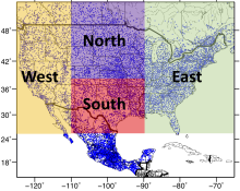 Livneh gridded precipitation and other meteorological variables for continental US, Mexico and southern Canada
Years of Record
- 1950-01 to 2013-12
The Livneh et al. (2015) hydrometeorological dataset consists of gridded daily and monthly precipitation, maximum and minimum air temperature, and wind speed for the continental US, southern Canada, and Mexico for the period 1950-2013. Gridded at 1/16° horizontal…
Main variables and Earth System components
Atmosphere Maximum Air Temperature Minimum Air Temperature Precipitation Wind-
Formats
- netCDF
-
Timestep
- Daily, Monthly
-
Domain
- North America
-
Collections
- None
Experts contributing reviews
- Livneh, Ben
 Argo Ocean Temperature and Salinity Profiles
Years of Record
- 2000-01 to 2025-07
Argo is an array of over 4100 profiling floats distributed almost uniformly across the global oceans. First deployed in 2000, Argo floats provide temperature and salinity profiles from the surface to a depth of 2000m. The array has approximately 1 float for…
Main variables and Earth System components
Ocean Salinity Sub Surface Salinity Sub Surface TemperatureExperts contributing reviews
- Scanderbeg, Megan | Purkey, Sarah | Willis, Josh
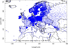 E-OBS: High-resolution gridded mean/max/min temperature, precipitation and sea level pressure for Europe & Northern Africa
Years of Record
- 1950-01 to 2019-07
E-OBS is a high spatial resolution daily gridded data that covers the European region and is based on the station data collated by the ECA&D initiative (Klein Tank et al., 2002). These data are supplied by many European National Meteorological Services and other data…
Main variables and Earth System components
Atmosphere Air Temperature Maximum Air Temperature Minimum Air Temperature Precipitation Sea Level PressureExperts contributing reviews
- van der Schrier, Gerard
 Coral geochemical records: An overview of their use as climate proxies and of available databases
Years of Record
Coral records are one of the main types of high-resolution (annual to sub-annual) paleoclimate proxies, providing timeseries of environmental conditions reaching hundreds to thousands of years into the past in the tropics, the central driver of the global atmospheric…
Main variables and Earth System components
Atmosphere Evaporation Evaporation-Precipitation Precipitation Ocean Salinity SST - sea surface temperature-
Formats
- ascii | HTML Table | Linked Paleo Data (LiPD) | Matlab
-
Timestep
-
Domain
- Atlantic Ocean, Indian Ocean, Pacific Ocean, Tropics
-
Collections
- None
Experts contributing reviews
- Lawman, Allison
 An overview of paleoclimate information from high-resolution lake sediment records: Strengths, limitations and key databases
Years of Record
Accumulated sediments at the bottom of lakes are invaluable archives of past climate and environmental change. These sediments contain a variety of physical, geochemical, and biological proxy indicators that can be used to gain a multi-faceted understanding of past…
Main variables and Earth System components
Atmosphere Air Temperature Precipitation Biosphere Pollen Land-
Formats
- ascii | csv | Linked Paleo Data (LiPD)
-
Timestep
- Annual, Decadal, Irregular
-
Domain
- Global
-
Collections
- None
Experts contributing reviews
- Larocca, Laura | Broadman, Ellie
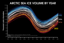 Pan-Arctic Ice Ocean Modeling and Assimilation System (PIOMAS)
Years of Record
- 1979-01 to 2023-08
The Pan-Arctic Ice-Ocean Modeling and Assimilation System (PIOMAS) is a reanalysis data set that uses a coupled ice and ocean model to provide daily and monthly estimates of Arctic sea-ice thickness. The data is publicly available from January 1979 to in near-real time.…
Experts contributing reviews
- Labe, Zachary
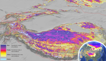 Global Permafrost Zonation Index Map
Years of Record
This data set contains a global (excluding Antarctica) 1 km map of permafrost zonation. It is an estimate of to what degree permafrost exists in a region nearly everywhere, or only in the most favorable conditions. These local conditions affecting permafrost occurrence…
Experts contributing reviews
- Gruber, Stephan
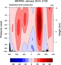 NASA MERRA
Years of Record
- 1979-01 to 2016-02
The Modern Era Retrospective-Analysis for Research and Applications (MERRA) was undertaken by NASA’s Global Modeling and Assimilation Office with two primary objectives: to place observations from NASA’s Earth Observing System satellites into a climate context and to…
Main variables and Earth System components
Atmosphere Air Temperature Geopotential Height Precipitable water Water Vapor-
Timestep
- Sub-daily, Monthly
-
Domain
- Global
Experts contributing reviews
- None
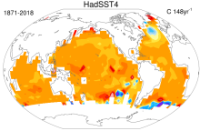 SST data: HadSST4
Years of Record
- 1850-01 to 2018-12
HadSST4 provides monthly SST anomalies on a 5°x5° grid for 1850-present. The anomalies are derived from a 30-year climatology spanning 1961-90. Coverage is global but there is no interpolation; Thus, missing data occur in the final product. This means that uncertainties…
-
Formats
- netCDF
-
Timestep
- Monthly
-
Domain
- Global
-
Collections
- Diagnostic Data Sets
Experts contributing reviews
- Kennedy, John
 Southern Ocean State Estimate (SOSE)
Years of Record
- 2005-01 to 2010-12
The Southern Ocean State Estimate (SOSE) is a model-generated best fit to Southern Ocean observations. As such, it provides a quantitatively useful climatology of the mean-state of the Southern Ocean. Technically, SOSE is a solution to the MITgcm. SOSE…
Main variables and Earth System components
Ocean 3D Velocity Bottom pressure SST - sea surface temperature Salinity Sub Surface Temperature mixed layer depth sea surface height u, v current components Wind Stress-
Formats
- binary
-
Timestep
- Daily, Monthly, Weekly, Annual
-
Collections
- None
Experts contributing reviews
- Mazloff, Matthew
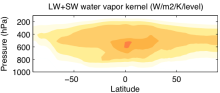 Radiative kernels from climate models
Years of Record
The radiative kernel technique is a method used to quantify radiative feedbacks in response to global warming. Radiative kernels are commonly calculated for the water vapor, lapse rate, temperature and albedo feedbacks. Radiative kernels are used to…
Main variables and Earth System components
Experts contributing reviews
- Pendergrass, Angeline
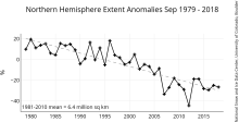 NSIDC Sea Ice Index
Years of Record
- 1978-10 to 2022-01
The NSIDC Sea Ice Index is a suite of easy-to-use sea ice analyses to track changes in Arctic and Antarctic sea ice. The product is produced and supported by the NOAA at NSIDC group and consists of browse imagery and data text files (CSV or Excel format). The input data…
Experts contributing reviews
- Meier, Walter
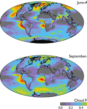 Cloud observations from MODIS
Years of Record
- 2000-03 to 2018-05
The Moderate Resolution Imaging Spectroradiometer (MODIS) is scanning instrument that makes measurements in 36 spectral bands from the visible to the thermal infrared at spatial resolutions from 250 m to 1 km. There are MODIS instruments aboard two sun-synchronous polar-…
-
Timestep
- Daily, Monthly, Weekly
-
Domain
- Global
-
Collections
- Diagnostic Data Sets, NCAR-DOE-CESM, atmosdiagnostics, Obs4MIPS
Experts contributing reviews
- Pincus, Robert
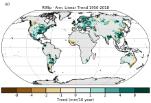 HadEX3: Gridded Temperature and Precipitation Climate Extremes Indices (CLIMDEX data)
Years of Record
- 1901-01 to 2018-12
HadEX3 provides gridded, station-based indices of temperature- and precipitation- related climate extremes and supersedes HadEX2. It is intended for global and continental climate monitoring, detection and attribution studies and climate model evaluation. Twenty-nine…
Main variables and Earth System components
Atmosphere Air Temperature at 2m Maximum Air Temperature Minimum Air Temperature Land Freeze/ThawExperts contributing reviews
- Dunn, Robert
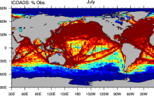 ICOADS Surface Marine Weather Observations
Years of Record
ICOADS (International Comprehensive Ocean-Atmosphere Data Set) is the most comprehensive archive of global marine surface climate observations available. Variables include SST, SLP, air temperature, wind speed, cloud amount, and others. There is no processing beyond…
Main variables and Earth System components
Atmosphere Air Temperature Budget Cloud Properties Latent & sensible heat flux Sea Level Pressure Specific Humidity Wind Ocean SST - sea surface temperatureExperts contributing reviews
- Deser, Clara
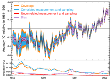
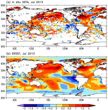 SST data: NOAA Extended Reconstruction SSTs, version 3 (ERSSTv3 & 3b)
Years of Record
- 1854-01 to 2020-02
Note: ERSST is currently on version 6. See the ERSSTv6 page here. The NOAA Extended Reconstruction Sea Surface Temperature (ERSST) provides global, spatially complete SST data at a monthly timestep for 1854-present. Version3 is based upon statistical interpolation…
-
Timestep
- Monthly
-
Domain
- Global
Experts contributing reviews
- Huang, Boyin | Livermore, Jay | Smith, Tom
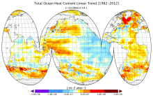 CMCC Global Ocean Reanalysis System (C-GLORS)
Years of Record
- 1982-01 to 2013-12
"The CMCC Global Ocean Physical Reanalysis System (C-GLORS) is used to simulate the state of the ocean in the last decades. It consists of a variational data assimilation system (OceanVar), capable of assimilating all in-situ observations along with altimetry data,…
Main variables and Earth System components
Ocean Ocean Heat Content SST - sea surface temperature Salinity Sub Surface Salinity Sub Surface Temperature mixed layer depth sea surface height u, v current componentsExperts contributing reviews
- Storto, Andrea
 HadISD: Sub-daily, non-interpolated weather station data
Years of Record
- 1931-01 to 2023-03
HadISD ("Hadley Centre Integrated Surface Database") is a compendium of subdaily weather-station data developed by the UK Met Office that is based on NOAA NCEI's Integrated Surface Database but with various quality-control checks implemented to remove stations with…
Main variables and Earth System components
Atmosphere Air Temperature at 2m Dew Point Temperature Precipitation Sea Level Pressure Storm data WindExperts contributing reviews
- Raymond, Colin
 AIRS and AMSU: Tropospheric air temperature and specific humidity
Years of Record
- 2002-09 to 2011-05
The Atmospheric Infrared Sounder (AIRS) project has generated decadal-length, global, gridded data sets of temperature and specific humidity for several standard levels in the troposphere for the obs4MIPS project. This obs4MIPS version of the AIRS data are available at…
Experts contributing reviews
- Tian, Baijun
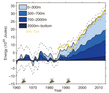
 ORAS4: ECMWF Ocean Reanalysis and derived ocean heat content
Years of Record
- 1958-01 to 2013-04
ECMWF's current ocean reanalysis uses a sophisticated data assimilation methodology which includes a model bias correction. The ocean model used is forced by atmospheric daily surface fluxes, relaxed to SST and bias corrected. The Balmaseda et al (QJRMS 2013) reference…
Main variables and Earth System components
Ocean Ocean Heat Content Salinity Sea Level potential temperature u, v current components-
Timestep
- Monthly
-
Domain
- Global
-
Collections
- Climate Analysis Section (CAS) Data Catalog
Experts contributing reviews
- None
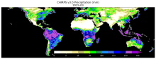 CHIRPS: Climate Hazards InfraRed Precipitation with Station data (Version 3)
Years of Record
- 1981-01 to 2025-06
Climate Hazards Group InfraRed Precipitation with Station data version 3 (CHIRPS v3)is a 1981-present, land-only, high resolution 0.05° gridded precipitation dataset. It combines thermal-infrared geostationary satellite-based estimates (CHIRP3), in situ observations from…
Main variables and Earth System components
Precipitation-
Formats
- GeoTIFF
-
Timestep
- Climatology, Monthly, Annual, Pentad
-
Domain
- Africa, Global, South America
-
Collections
- None
Experts contributing reviews
- Alaso, Daniella
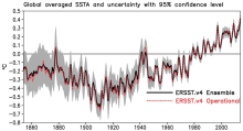 SST data: NOAA Extended Reconstruction SSTs, Version 4
Years of Record
- 1981-10 to 2022-02
Note: ERSST is currently on version 6. See the ERSSTv6 page here. The NOAA Extended Reconstruction Sea Surface Temperature (ERSST) provides global, spatially complete SST data at a monthly timestep for 1854-present. Compared to the previous version, Version 4…
Experts contributing reviews
- Huang, Boyin
 Combined CloudSat spaceborne radar and CALIPSO spaceborne lidar cloud fraction dataset (3S-GEOPROF-COMB)
Years of Record
- 2006-07 to 2019-07
A global (82S-82N) cloud fraction data set, providing a unique view of cloud vertical structure, has been developed based on the complimentary spaceborne remote sensing capabilities of the CloudSat radar and the CALISPSO lidar. The data set provides monthly mean cloud…
-
Formats
- netCDF
-
Timestep
- Monthly, Seasonal, Annual
-
Domain
- Global
-
Collections
- Diagnostic Data Sets, NCAR-DOE-CESM, atmosdiagnostics
Experts contributing reviews
- Bertrand, Leah | Kay, Jennifer
 SST data: HadSST3
Years of Record
- 1850-01 to 2017-12
HadSST3 provides monthly SST anomalies on a 5°x5° grid for 1850-present. The anomalies are derived from a 30-year climatology spanning 1961-90.Coverage is global but there is no interpolation; Thus, missing data occur in the final product. The primary input data are from…
-
Timestep
- Monthly
-
Domain
- Global
Experts contributing reviews
- Kennedy, John
 Ocean temperature analysis and heat content estimate from Institute of Atmospheric Physics
Years of Record
- 1940-01 to 2016-12
The Institute of Atmospheric Physics (IAP) ocean temperature analysis features global coverage of the oceans, at 1° x1° horizontal resolution on 41 vertical levels from 1-2000m, and monthly resolution from 1940 to present. As such, it is aimed at studies of climate…
Main variables and Earth System components
Ocean Ocean Heat Content Sea Level Sub Surface TemperatureExperts contributing reviews
- Cheng, Lijing
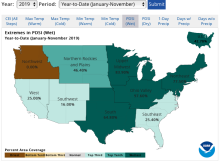 U.S. Climate Extremes Index (CEI)
Years of Record
- 1910-01 to 2019-11
The U.S. Climate Extremes Index (CEI) was first presented in 1995 as a framework for quantifying observed changes in climate within the contiguous United States. At present, the CEI evaluates the percent area of extremes in the distribution of much above/below…
Main variables and Earth System components
Atmosphere Air Temperature Maximum Air Temperature Minimum Air Temperature Precipitation Wind Land Drought-
Formats
- ascii
-
Timestep
- Monthly, Seasonal, Annual
-
Domain
- North America
-
Collections
- None
Experts contributing reviews
- Gleason, Karin
 Making sense of data from Land Surface Models (LSMs)
Years of Record
The land surface is a dynamic and complex component of the Earth system, shaping climate and biogeochemical cycles and serving as the origin of many anthropogenic impacts on the planet. Comprising complex and interactive organic and inorganic systems (soils, rocks, water…
-
Formats
-
Timestep
-
Domain
-
Collections
- None
Experts contributing reviews
- Mankin, Justin | Lesk, Corey
 SMAP-Derived 1-km Downscaled Surface Soil Moisture
Years of Record
- 2015-04 to 2022-09
This data product contains global daily 1 km resolution surface soil moisture (SM) derived from the Soil Moisture Active Passive (SMAP) L-band radiometer observations. Specifically, Moderate Resolution Imaging Spectroradiometer (MODIS) land surface temperature and…
-
Formats
-
Timestep
- Daily
-
Domain
- Global
-
Collections
- None
Experts contributing reviews
- Lakshmi, Venkataraman | Fang, Bin
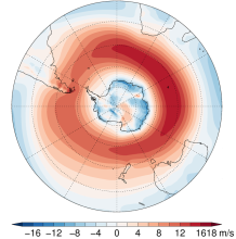 Southern Hemisphere westerly jet strength and position
Years of Record
- 1979-12 to 2016-12
The dynamics of the Southern Hemisphere westerly jet are described in terms of two indices, jet strength and jet latitude. Here, these indices are defined using the ERA-Interim reanalysis, although other datasets, including climate models, could be used. …
-
Formats
- ascii
-
Timestep
- Seasonal, Annual
-
Collections
- None
Experts contributing reviews
- Bracegirdle, Thomas J.
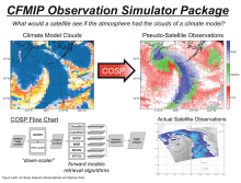 COSP: Cloud Feedback Model Intercomparison Project (CFMIP) Observation Simulator Package
Years of Record
Cloud processes and feedbacks are recognized as the largest uncertainty in climate model projections. Progress in understanding the roles of clouds in the response of the Earth to changes in external forcing (GHG, aerosoles, etc.) has in part been hampered by the lack of…
-
Formats
-
Timestep
-
Domain
- Global
-
Collections
- Diagnostic Data Sets, NCAR-DOE-CESM, atmosdiagnostics
Experts contributing reviews
- Kay, Jennifer
 Drought atlases from tree rings
Years of Record
- 0000-01 to 2005-12
Tree-ring drought atlases provide a paleoclimate analog to modern drought indices, most commonly the Palmer Drought Severity Index (PDSI). Produced on a regular lat-lon grid for regions such as North America, Europe, and Australia, these centuries-long datasets are…
-
Timestep
- Annual
-
Domain
- North America
-
Collections
- None
Experts contributing reviews
- Cook, Edward
 Speleothems and the SISAL database: An overview of the use of speleothems as archives of climate proxies
Years of Record
Speleothems provide globally distributed, seasonal to multi-annual resolution climate records encoded in multiple proxies including oxygen and carbon stable isotopes, and trace elements. Speleothems, such as stalagmites and flowstones, are secondary cave carbonate…
Main variables and Earth System components
-
Formats
-
Timestep
- Annual, Decadal, Irregular
-
Domain
- Global
-
Collections
- None
Experts contributing reviews
- Kaushal, Nikita | Lechleitner, Franziska
 CERA-20C: ECMWF's Coupled Ocean-Atmosphere Reanalysis of the 20th Century
Years of Record
- 1901-01 to 2010-12
The CERA-20C is a global, coupled reanalysis spanning 1901-2010 with a focus on low-frequency climate variability. Similar to ERA-20C, the surface observations assimilated include surface pressures from the International Surface Pressure Databank v3.2.6 and ICOADS v…
Main variables and Earth System components
Atmosphere Multiple variables Cryosphere Sea Ice Concentration OceanExperts contributing reviews
- Laloyaux, Patrick
 COREv2 Air-Sea Surface Fluxes
Years of Record
- 1949-01 to 2006-12
The Coordinated Ocean Research Experiments version 2 (COREv2) data set consists of a globally complete set of air-sea fluxes of momentum, heat and freshwater for 1948-2009 at monthly resolution. This data set serves as a set of common atmospheric boundary…
Main variables and Earth System components
Atmosphere Evaporation Precipitation Radiation Wind Stress Land Runoff and Streamflow Ocean Surface Flux-
Formats
- netCDF
-
Timestep
- Monthly
-
Domain
- Global
-
Collections
- Diagnostic Data Sets, NCAR-DOE-CESM, atmosdiagnostics, oceandiagnostics
Experts contributing reviews
- Yeager, Stephen
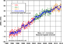 Global Mean Sea Level from TOPEX & Jason Altimetry
Years of Record
- 1992-10 to 2015-10
The global mean sea level timeseries is an excellent, integrative indicator of long-term global temperature trends, providing a record that is observed and processed independent of common metrics like global surface air temperature. The major contributions to the…
Experts contributing reviews
- Nerem, R.S.
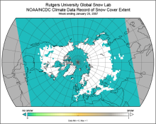 Snow Cover Extent (Northern Hemisphere) Climate Data Record, by Rutgers
Years of Record
- 1966-10 to 2021-09
The Snow Cover Extent Climate Data Record extends from the late 1960s to present. Historical analyses based on visual inspection have been digitized and combined with modern multi-spectral remote sensing to produce a seamless record on a hemispheric scale. The data are…
-
Timestep
- Monthly, Weekly
-
Domain
- North America
-
Collections
- Climate Data Record, Diagnostic Data Sets, NCAR-DOE-CESM, landdiagnostics
Experts contributing reviews
- Estilow, Thomas W. | Robinson, David
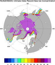 Sea Ice Concentration: NOAA/NSIDC Climate Data Record
Years of Record
- 1978-10 to 2023-12
The NOAA/NSIDC Climate Data Record (CDR) of sea ice concentration is available at 25 x 25 km spatial resolution in daily or monthly timesteps for 1987-2014. It provides a consistent interpretation of sea ice for the satellite record, with the intent of being suitable for…
-
Formats
- netCDF
-
Timestep
- Daily, Monthly
-
Collections
- Climate Data Record
Experts contributing reviews
- Meier, Walter
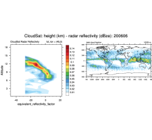 CloudSat
Years of Record
- 2006-06 to 2010-11
CloudSat is a satellite mission designed to measure the vertical structure of clouds from space. The radar data produces detailed images of cloud structures. CloudSat is one of a constellation of satellites known as the A-Train (Cloudsat, CALIPSO, PARASOL, Aqua, Aura,…
Experts contributing reviews
- None